Jump to content


Main menu


Navigation  


Main page
Contents
Current events
Random article
About Wikipedia
Contact us
Donate


Contribute  


Help
Learn to edit
Community portal
Recent changes
Upload file


Search  


Create account

Log in


Create account
 Log in


Pages for logged out editors learn more  


Contributions
Talk


Contents


(Top)


1 Founding  


2 Geography  


3 See also  


4 References  


Kharagauli


Čeština
Eesti
Español
Euskara
فارسی
Français
Հայերեն
Ирон
Italiano
עברית


Мокшень
Nederlands
Нохчийн
Oʻzbekcha / ўзбекча
Polski
Русский
Svenska
Українська
Winaray


Edit links


Article
Talk


Read
Edit
View history


Tools


Actions  


Read
Edit
View history


General  


What links here
Related changes
Upload file
Special pages
Permanent link
Page information
Cite this page
Get shortened URL
Download QR code
Wikidata item


Print/export  


Download as PDF
Printable version


In other projects  


Wikimedia Commons


Appearance


Coordinates: 42°0100N 43°1200E / 42.01667°N 43.20000°E / 42.01667; 43.20000
 

From Wikipedia, the free encyclopedia


Kharagauli
ხარაგაული
Kharagauli is located in Georgia
Kharagauli

Kharagauli

Location of Kharagauli in Georgia

Coordinates: 42°01′00N 43°12′00E / 42.01667°N 43.20000°E / 42.01667; 43.20000
Country Georgia
MkhareImereti
MunicipalityKharagauli
Population
 (2014)
 • Total1,965
Time zoneUTC+4 (Georgian Time)
Map

Kharagauli (Georgian: ხარაგაული) is an administrative center of Kharagauli districtinGeorgia. It is situated on both banks of Chkherimela [ka] river in a narrow and deep gorge, 280-400m above the sea level.

Founding

[edit]

It was founded as a railway station in the 1870s, when the Poti-Tbilisi railway was built. Kharagauli assumed an administrative, later an economic, function.

Geography

[edit]

In the west entrance of the area, the Chkherimela river flows through a narrow gorge. On the left bank of the river, there are two statues of giants; on the right, two large holes. This area, referred to as "the giant's hole"[citation needed] serves as a minor tourist attraction. The riverbank also has a large park.

Up the gorge, there are ruins of an old fortress from the Middle Ages, referred to as Khandi or Kharagauli Fortress. The fortress is notable for being the site at which Vakhtang VI of Kartli was married.[1] Additionally, there are tombs on a mountain nearby from the 14th to 11th centuries BCE, as well as the ruins of a Christian church.[citation needed]

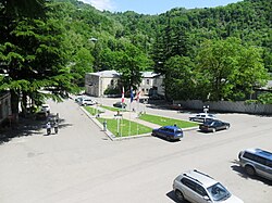
In the center of the borough, there is a three-story administration building. There are three secondary schools in the region, one seminary, two kindergartens, a hospital, a polyclinic, a library, a musical school, a theatre, a court, a post office, a museum of regional studies, two factories (furniture and industrial manufacturing), and communication departments. As in much of Imereti, production of wine (and derived drinks) is a notable sector of the economy; the cognacs Ubisa and Nunisi are produced there on spring water.

See also

[edit]

References

[edit]
  1. ^ Brosset, Marie-Félicité (1856). Histoire de la Géorgie depuis l'Antiquité jusqu'au XIXe siècle. IIe partie. Histoire moderne [History of Georgia from Antiquity to the 19th century. Part II. Modern History] (in French). S.-Pétersbourg: A la typographie de l'Academie Impériale des Sciences. pp. 23, 32, 42.


  • t
  • e

  • Retrieved from "https://en.wikipedia.org/w/index.php?title=Kharagauli&oldid=1197269499"

    Categories: 
    Cities and towns in Imereti
    Kutaisi Governorate
    Populated places in Kharagauli Municipality
    Georgia (country) geography stubs
    Hidden categories: 
    Pages using gadget WikiMiniAtlas
    CS1 French-language sources (fr)
    Articles with short description
    Short description matches Wikidata
    Coordinates on Wikidata
    Infobox mapframe without OSM relation ID on Wikidata
    Articles containing Georgian-language text
    All articles with unsourced statements
    Articles with unsourced statements from November 2020
    Commons category link is on Wikidata
    All stub articles
    Pages using the Kartographer extension


    This page was last edited on 19 January 2024, at 20:35 (UTC).

    Text is available under the Creative Commons Attribution-ShareAlike License 4.0; additional terms may apply. By using this site, you agree to the Terms of Use and Privacy Policy. Wikipedia® is a registered trademark of the Wikimedia Foundation, Inc., a non-profit organization.


    Privacy policy

    About Wikipedia

    Disclaimers

    Contact Wikipedia

    Code of Conduct

    Developers

    Statistics

    Cookie statement

    Mobile view


    Wikimedia Foundation
    Powered by MediaWiki