J u m p t o c o n t e n t
M a i n m e n u
M a i n m e n u
N a v i g a t i o n
● M a i n p a g e ● C o n t e n t s ● C u r r e n t e v e n t s ● R a n d o m a r t i c l e ● A b o u t W i k i p e d i a ● C o n t a c t u s ● D o n a t e
C o n t r i b u t e
● H e l p ● L e a r n t o e d i t ● C o m m u n i t y p o r t a l ● R e c e n t c h a n g e s ● U p l o a d f i l e
S e a r c h
Search
A p p e a r a n c e
● C r e a t e a c c o u n t ● L o g i n
P e r s o n a l t o o l s
● C r e a t e a c c o u n t ● L o g i n
P a g e s f o r l o g g e d o u t e d i t o r s l e a r n m o r e ● C o n t r i b u t i o n s ● T a l k
( T o p )
1 C o u r s e
T o g g l e C o u r s e s u b s e c t i o n
1 . 1 T r i b u t a r i e s
2 S e e a l s o
3 R e f e r e n c e s
T o g g l e t h e t a b l e o f c o n t e n t s
K h u d o s e y
1 2 l a n g u a g e s
● Б а ш ҡ о р т с а ● C e b u a n o ● D e u t s c h ● I t a l i a n o ● Қ а з а қ ш а ● K o t a v a ● К ы р г ы з ч а ● M a g y a r ● م ص ر ى ● Р у с с к и й ● Т а т а р ч а / t a t a r ç a ● 中 文
E d i t l i n k s
● A r t i c l e ● T a l k
E n g l i s h
● R e a d ● E d i t ● V i e w h i s t o r y
T o o l s
T o o l s
A c t i o n s
● R e a d ● E d i t ● V i e w h i s t o r y
G e n e r a l
● W h a t l i n k s h e r e ● R e l a t e d c h a n g e s ● U p l o a d f i l e ● S p e c i a l p a g e s ● P e r m a n e n t l i n k ● P a g e i n f o r m a t i o n ● C i t e t h i s p a g e ● G e t s h o r t e n e d U R L ● D o w n l o a d Q R c o d e ● W i k i d a t a i t e m
P r i n t / e x p o r t
● D o w n l o a d a s P D F ● P r i n t a b l e v e r s i o n
A p p e a r a n c e
C o o r d i n a t e s : 6 5 ° 3 6 ′ 08 ″ N 8 2 ° 2 3 ′ 15 ″ E / 6 5 . 6 0 2 1 ° N 8 2 . 3 8 7 4 ° E / 65.6021; 82.3874
F r o m W i k i p e d i a , t h e f r e e e n c y c l o p e d i a
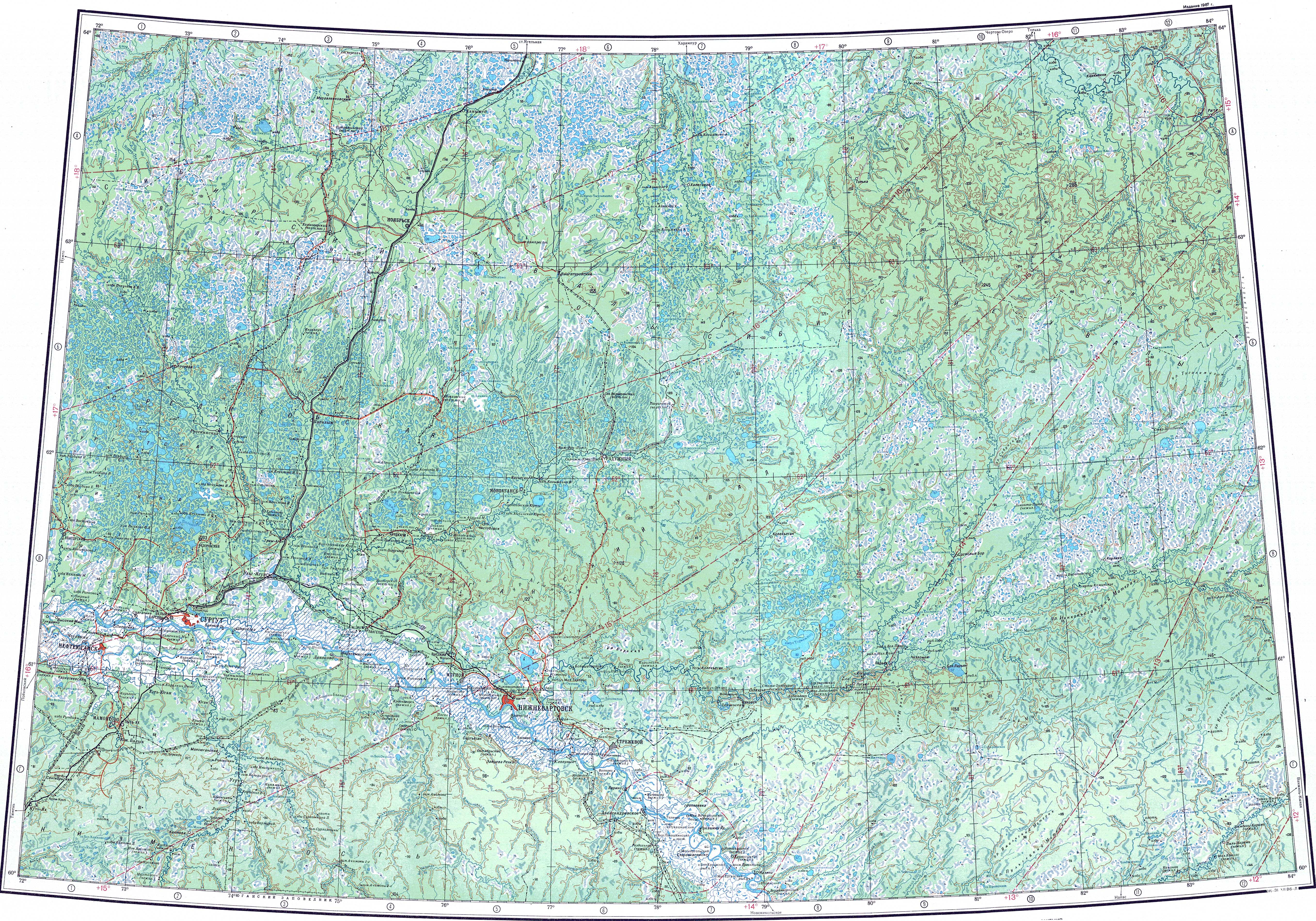
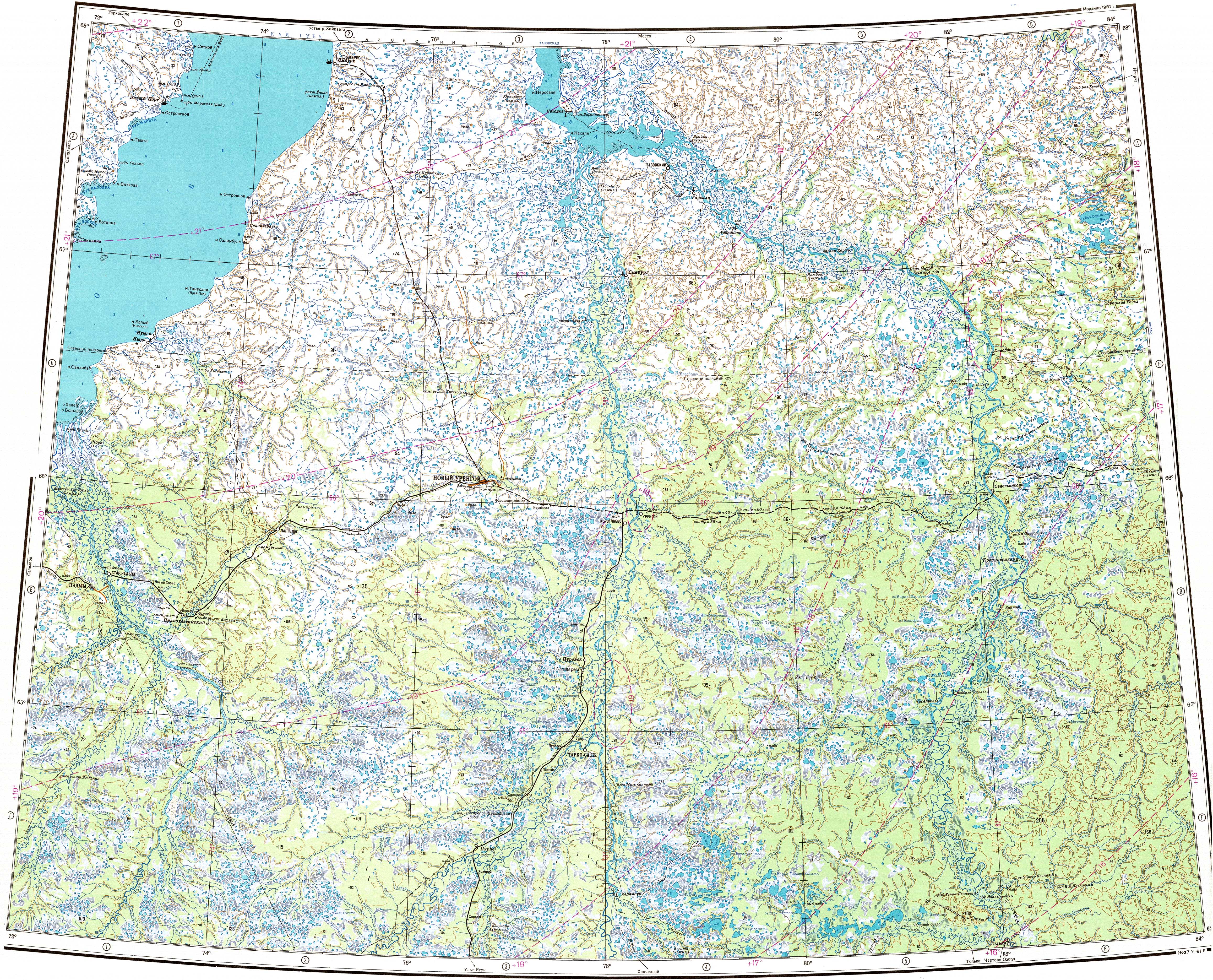
The Khudosey (Russian : Худосей ) is a river in the West Siberian Plain , Russia . It is a right tributary of the Taz . It is 409 kilometres (254 mi ) long, and has a drainage basin of 11,200 square kilometres (4,300 sq mi ).[1]
Its source is in the Yamalo-Nenets Autonomous Okrug and after about 5 km (3.1 mi ) downstream it crosses into Krasnoyarsk Krai . It meets the right bank of the Taz 412 km (256 mi ) from its mouth in the Taz Estuary of the Kara Sea.[2] [3] [4]
Tributaries [ edit ]
The main tributaries of the Khudosey are the 114 km (71 mi ) long Kashky (Кашкы) and the 113 km (70 mi ) long Pokalky (Покалькы) on the right, as well as the 126 km (78 mi ) long Limpypitylky (Лимпыпитылькы) on the left. The river is frozen between late October and late May.[2] [5] [1]
Drainage basin of the Taz River.
See also [ edit ]
References [ edit ]
^ "Q-43_44 Topographic Chart (in Russian)" . Retrieved 11 June 2022 .
^ Google Earth
^ Информационный, образовательный, культурный центр города Губкинского Ямало-Ненецкого автономного округа
t
e
R e t r i e v e d f r o m " https://en.wikipedia.org/w/index.php?title=Khudosey&oldid=1092597466 " C a t e g o r i e s : ● R i v e r s o f Y a m a l o - N e n e t s A u t o n o m o u s O k r u g ● R i v e r s o f K r a s n o y a r s k K r a i ● T r i b u t a r i e s o f t h e T a z ● R u s s i a r i v e r s t u b s H i d d e n c a t e g o r i e s : ● P a g e s u s i n g g a d g e t W i k i M i n i A t l a s ● C S 1 R u s s i a n - l a n g u a g e s o u r c e s ( ru ) ● A r t i c l e s w i t h s h o r t d e s c r i p t i o n ● S h o r t d e s c r i p t i o n i s d i f f e r e n t f r o m W i k i d a t a ● C o o r d i n a t e s o n W i k i d a t a ● A r t i c l e s c o n t a i n i n g R u s s i a n - l a n g u a g e t e x t ● A l l s t u b a r t i c l e s
● T h i s p a g e w a s l a s t e d i t e d o n 1 1 J u n e 2 0 2 2 , a t 0 8 : 5 5 ( U T C ) . ● T e x t i s a v a i l a b l e u n d e r t h e C r e a t i v e C o m m o n s A t t r i b u t i o n - S h a r e A l i k e L i c e n s e 4 . 0 ;
a d d i t i o n a l t e r m s m a y a p p l y . B y u s i n g t h i s s i t e , y o u a g r e e t o t h e T e r m s o f U s e a n d P r i v a c y P o l i c y . W i k i p e d i a ® i s a r e g i s t e r e d t r a d e m a r k o f t h e W i k i m e d i a F o u n d a t i o n , I n c . , a n o n - p r o f i t o r g a n i z a t i o n . ● P r i v a c y p o l i c y ● A b o u t W i k i p e d i a ● D i s c l a i m e r s ● C o n t a c t W i k i p e d i a ● C o d e o f C o n d u c t ● D e v e l o p e r s ● S t a t i s t i c s ● C o o k i e s t a t e m e n t ● M o b i l e v i e w


