Jump to content


Main menu


Navigation  


Main page
Contents
Current events
Random article
About Wikipedia
Contact us
Donate


Contribute  


Help
Learn to edit
Community portal
Recent changes
Upload file


Search  


Create account

Log in


Create account
 Log in


Pages for logged out editors learn more  


Contributions
Talk


Contents


(Top)


1 Communes  


2 References  


Kidal Cercle


 / Bân-lâm-gú
Cebuano
Deutsch
Eesti
Ελληνικά
Español
فارسی
Français
Italiano

Norsk bokmål
Suomi
Svenska


Edit links


Article
Talk


Read
Edit
View history


Tools


Actions  


Read
Edit
View history


General  


What links here
Related changes
Upload file
Special pages
Permanent link
Page information
Cite this page
Get shortened URL
Download QR code
Wikidata item


Print/export  


Download as PDF
Printable version


In other projects  


Wikimedia Commons


Appearance


Coordinates: 18°30N 1°25E / 18.500°N 1.417°E / 18.500; 1.417
 

From Wikipedia, the free encyclopedia


Kidal
Kidal Cercle in Mali
Country Mali
RegionKidal Region
CapitalKidal
Area
 • Total21,353 km2 (8,244 sq mi)
Population
 (2009)[2]
 • Total33,087
 • Density1.5/km2 (4.0/sq mi)
Time zoneUTC+0 (GMT)

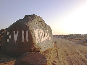
Kidal Cercle is an administrative subdivision of the Kidal RegionofMali. The administrative center (chef-lieu) is the town of Kidal. The cercle is divided into rural and urban communes, and below this, quarters/villages. In 2009 the cercle had a population of 33,087.[2]

The climate is typical Saharian with very little rainfall and large fluctuations in temperature. The average annual rainfall is around 130 mm but there are large year-to-year variations with 204 mm recorded in 1999 and only 66 mm in 1990.[1]

The mountain region of Adrar des Ifoghas was taken by French and Chadian forces on 22 February 2013 as part of the Northern Mali conflict. The area of In Arab, near Anefif, was capturedbyMNLA forces on 29–30 March 2013.

Communes

[edit]

The Kidal Cercle contains the following communes:[3]

References

[edit]
  1. ^ a b Programme de renforcement des capacités nationales pour une gestion stratégique du développement (PRECAGED): Schéma d'aménagement et de développement du Cercle de Kidal, République du Mali: Ministère de l'économie programme des nations unies et des finances, 2002, archived from the original on 2012-03-17, retrieved 2011-08-20
  • ^ a b Resultats Provisoires RGPH 2009 (Région de Kidal) (PDF), République de Mali: Institut National de la Statistique, archived from the original (PDF) on 2012-07-27, retrieved 2012-05-12
  • ^ Communes de la Région de Kidal (PDF) (in French), Ministère de l’administration territoriale et des collectivités locales, République du Mali, archived from the original (PDF) on 2012-03-09.
  • 18°30′N 1°25′E / 18.500°N 1.417°E / 18.500; 1.417


  • t
  • e

  • Retrieved from "https://en.wikipedia.org/w/index.php?title=Kidal_Cercle&oldid=1153937877"

    Categories: 
    Cercles of Mali
    Kidal Region
    Mali geography stubs
    Hidden categories: 
    CS1 French-language sources (fr)
    Pages using gadget WikiMiniAtlas
    Articles with short description
    Short description is different from Wikidata
    Pages using infobox settlement with no coordinates
    Coordinates on Wikidata
    All stub articles


    This page was last edited on 9 May 2023, at 07:24 (UTC).

    Text is available under the Creative Commons Attribution-ShareAlike License 4.0; additional terms may apply. By using this site, you agree to the Terms of Use and Privacy Policy. Wikipedia® is a registered trademark of the Wikimedia Foundation, Inc., a non-profit organization.


    Privacy policy

    About Wikipedia

    Disclaimers

    Contact Wikipedia

    Code of Conduct

    Developers

    Statistics

    Cookie statement

    Mobile view


    Wikimedia Foundation
    Powered by MediaWiki