Jump to content


Main menu


Navigation  


Main page
Contents
Current events
Random article
About Wikipedia
Contact us
Donate


Contribute  


Help
Learn to edit
Community portal
Recent changes
Upload file


Search  


Create account

Log in


Create account
 Log in


Pages for logged out editors learn more  


Contributions
Talk


Contents


(Top)


1 History  


2 Television  


3 References  


4 External links  


Killiecrankie


Deutsch
Español
Euskara
فارسی
Gaeilge
Gàidhlig
 

Edit links


Article
Talk


Read
Edit
View history


Tools


Actions  


Read
Edit
View history


General  


What links here
Related changes
Upload file
Special pages
Permanent link
Page information
Cite this page
Get shortened URL
Download QR code
Wikidata item


Print/export  


Download as PDF
Printable version


In other projects  


Wikimedia Commons


Appearance


Coordinates: 56°4442N 03°4644W / 56.74500°N 3.77889°W / 56.74500; -3.77889
 

From Wikipedia, the free encyclopedia


Killiecrankie

Killiecrankie

Killiecrankie is located in Perth and Kinross
Killiecrankie

Killiecrankie

Location within Perth and Kinross

OS grid referenceNN913628
Civil parish
Council area
CountryScotland
Sovereign stateUnited Kingdom
PoliceScotland
FireScottish
AmbulanceScottish
UK Parliament
Scottish Parliament
List of places
UK
Scotland
56°44′42N 03°46′44W / 56.74500°N 3.77889°W / 56.74500; -3.77889
View from the bridge at Lin of Tummel

Killiecrankie (/ˌkɪlˈkræŋk/ ; (Scottish Gaelic: Coille Chreithnich, meaning aspen wood) is a village in Perth and Kinross, Scotland on the River Garry. It lies at the Pass of Killiecrankie, by the A9 road which has been bypassed since 1986.[1] The village is home to a power station forming part of the Tummel Hydro-Electric Power Scheme. Much of the riverbank is owned by the National Trust for Scotland. The nearby 10 arch railway viaduct, which runs for 109 yards (100 m) along the north-east bank of the River Garry,[2] was built in 1863 from a design by Joseph Mitchell.

History[edit]

In 1689, during the Jacobite Rebellion, the Battle of Killiecrankie was fought on the northern edge of the village. The Highland charge of the Jacobites took the government forces under General Hugh MacKay by surprise and completely overwhelmed them in only 10 minutes. Donald MacBean, one of William II of Scotland's supporters, having lost the contest, is said to have cleared the pass, from one bank to the other, at "The Soldier's Leap". One of the most famous leaders of the rebellion John Graham of Claverhouse, Viscount Dundee was killed in the battle. A Memorial Field to the fallen soldiers lies within the grounds of the category B listed Urrard House.[3] An eponymous folk song, Braes o' Killiecrankie, commemorates the battle. A 1966 recording by The Corries was a pioneering use of the music video.
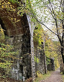
Killicrankie viaduct
Information plaque about the Killiecrankie viaduct

According to official records, the last wolf in Great Britain was killed near Killiecrankie in 1680.[4]

Television[edit]

Mary Ann Kennedy was the presenter of a BBC Four television series The Highland Sessions, which was filmed in Killiecrankie. Many notable musicians and singers from Ireland and Scotland performed in the sessions.[5]

References[edit]

Glen Garry, taken from Meall Uaine, looking past Killiecrankie and Auldclune towards Blair Atholl
  1. ^ Ordnance Survey, Great Britain (2008), "Braemar and Blair Atholl", Ordnance Survey Landranger Map (C2 ed.), ISBN 978-0-319-23119-7
  • ^ Byrom, Bernard (2022). Old Blair Atholl, Killiecrankie and Struan. Catrine: Stenlake Publishing Ltd. p. 6. ISBN 978-1-84033-929-1.
  • ^ "Urrard House". Historic Scotland. Retrieved 24 July 2013.
  • ^ Shoberl, Frederic (1834). Natural History of Quadrupeds. J. Harris.
  • ^ "The Highland Sessions". All Celtic Music. Retrieved 17 December 2010.
  • External links[edit]


  • t
  • e

  • Retrieved from "https://en.wikipedia.org/w/index.php?title=Killiecrankie&oldid=1184255019"

    Categories: 
    Villages in Perth and Kinross
    Perth and Kinross geography stubs
    Hidden categories: 
    Pages using gadget WikiMiniAtlas
    Pages using the Phonos extension
    Articles with short description
    Short description is different from Wikidata
    Use dmy dates from February 2017
    Use British English from February 2017
    Articles containing Scottish Gaelic-language text
    Articles with OS grid coordinates
    Coordinates on Wikidata
    Pages including recorded pronunciations
    Commons category link from Wikidata
    Wikipedia articles incorporating a citation from the 1911 Encyclopaedia Britannica with Wikisource reference
    All stub articles


    This page was last edited on 9 November 2023, at 07:53 (UTC).

    Text is available under the Creative Commons Attribution-ShareAlike License 4.0; additional terms may apply. By using this site, you agree to the Terms of Use and Privacy Policy. Wikipedia® is a registered trademark of the Wikimedia Foundation, Inc., a non-profit organization.


    Privacy policy

    About Wikipedia

    Disclaimers

    Contact Wikipedia

    Code of Conduct

    Developers

    Statistics

    Cookie statement

    Mobile view


    Wikimedia Foundation
    Powered by MediaWiki