Jump to content


Main menu


Navigation  


Main page
Contents
Current events
Random article
About Wikipedia
Contact us
Donate


Contribute  


Help
Learn to edit
Community portal
Recent changes
Upload file


Search  


Create account

Log in


Create account
 Log in


Pages for logged out editors learn more  


Contributions
Talk


Contents


(Top)


1 Etymology  


2 Geography  


3 History  


3.1  2022 Russian invasion  


4 References  


Kinburn Peninsula


Беларуская
Беларуская (тарашкевіца)
Български
Čeština
Deutsch
Eesti
Español
Français

Hrvatski
Italiano
Latviešu
Lietuvių
Nederlands

Polski
Português
Русский
Suomi
Svenska
Українська


Edit links


Article
Talk


Read
Edit
View history


Tools


Actions  


Read
Edit
View history


General  


What links here
Related changes
Upload file
Special pages
Permanent link
Page information
Cite this page
Get shortened URL
Download QR code
Wikidata item


Print/export  


Download as PDF
Printable version


In other projects  


Wikimedia Commons


Appearance


Coordinates: 46°3027N 31°4644E / 46.50750°N 31.77889°E / 46.50750; 31.77889
 

From Wikipedia, the free encyclopedia


Kinburn Peninsula
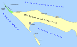
A map of Kinburn Peninsula
Kinburn Peninsula is located in Kherson Oblast
Kinburn Peninsula

Kinburn Peninsula

Kinburn Peninsula is located in Ukraine
Kinburn Peninsula

Kinburn Peninsula

Coordinates: 46°30′27N 31°46′44E / 46.50750°N 31.77889°E / 46.50750; 31.77889
LocationPokrovka, Pokrovske, Vasylivka (Mykolaiv Oblast) and Heroiske (Kherson Oblast), Ukraine
Part of
Map
Dimensions
 • Length40 kilometres (25 mi)[1]
 • Width10 kilometres (6.2 mi)

The Kinburn Peninsula (Ukrainian: Кінбурнський півострів, romanizedKinburnskyi pivostriv, Russian: Кинбурнский полуостров, romanizedKinburnskiy poluostrov, Turkish: Kılburun) is a peninsula in Southern Ukraine, which separates the Dnieper–Bug estuary from the Black Sea. Administratively the peninsula is divided between two regions: Mykolaiv Oblast and Kherson Oblast, population 1,450. It is part of the Ivory Coast of Sviatoslav National Nature Park. Since April 2022, the Kinburn Peninsula has been fully occupied by Russian forces.

Etymology[edit]

Etymology comes from Turkish Kılburun, literally 'nose (land strip) [as subtle as a] hair'.[2]

Geography[edit]

The western tip of the peninsula extends into the Kinburn Spit.

To the south is a pair of islands, Dovhyi and Kruhlyi - both belong administratively to the Mykolaiv RaionofMykolaiv Oblast.[3]

The peninsula includes the villages of Pokrovka, Pokrovske and Vasylivka, in Mykolaiv Oblast, and Heroiske, in the Kherson Oblast.

History[edit]

The Battle of Kinburn was fought on 12 October (N.S.)/1 October (O.S.) 1787 as part of the Russo-Turkish War (1787–1792).

The Battle of Kinburn was fought on 17 October 1855 as part of the Crimean War.

2022 Russian invasion[edit]

References[edit]

  1. ^ Land of Achilles and Prince Svyatoslav. Svyatoslav's White Coast National Park website, nationalparkbilosvyat.org.ua.
  • ^ "Ḳi̇lburun". referenceworks.brillonline.com. 24 April 2012.
  • ^ Black Sea islands of Mykolaiv Oblast archived from www.library.vn.ua
  • t
  • e
  • t
  • e

  • Retrieved from "https://en.wikipedia.org/w/index.php?title=Kinburn_Peninsula&oldid=1209506416"

    Categories: 
    Geography of Kherson Oblast
    Peninsulas of Ukraine
    Geography of Mykolaiv Oblast
    Ochakiv urban hromada
    Ukraine geography stubs
    Kherson Oblast geography stubs
    Hidden categories: 
    Pages using gadget WikiMiniAtlas
    Articles needing additional references from November 2022
    All articles needing additional references
    Articles with short description
    Short description is different from Wikidata
    Coordinates on Wikidata
    Articles containing Ukrainian-language text
    Articles containing Russian-language text
    Articles containing Turkish-language text
    Articles with FAST identifiers
    Articles with VIAF identifiers
    Articles with J9U identifiers
    Articles with LCCN identifiers
    Articles with EMU identifiers
    All stub articles
    Pages using the Kartographer extension


    This page was last edited on 22 February 2024, at 06:36 (UTC).

    Text is available under the Creative Commons Attribution-ShareAlike License 4.0; additional terms may apply. By using this site, you agree to the Terms of Use and Privacy Policy. Wikipedia® is a registered trademark of the Wikimedia Foundation, Inc., a non-profit organization.


    Privacy policy

    About Wikipedia

    Disclaimers

    Contact Wikipedia

    Code of Conduct

    Developers

    Statistics

    Cookie statement

    Mobile view


    Wikimedia Foundation
    Powered by MediaWiki