Jump to content


Main menu


Navigation  


Main page
Contents
Current events
Random article
About Wikipedia
Contact us
Donate


Contribute  


Help
Learn to edit
Community portal
Recent changes
Upload file


Search  


Create account

Log in


Create account
 Log in


Pages for logged out editors learn more  


Contributions
Talk


Contents


(Top)


1 References  


2 External links  


Kingsland Road


Add links


Article
Talk


Read
Edit
View history


Tools


Actions  


Read
Edit
View history


General  


What links here
Related changes
Upload file
Special pages
Permanent link
Page information
Cite this page
Get shortened URL
Download QR code
Wikidata item


Print/export  


Download as PDF
Printable version


In other projects  


Wikimedia Commons


Appearance


Coordinates: 51°3218N 0°0436W / 51.53844°N 0.07676°W / 51.53844; -0.07676
 

From Wikipedia, the free encyclopedia


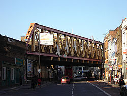
Kingsland Road looking north from the point where it becomes Shoreditch High Street. (January 2006).

Kingsland Road is the name given to an East London stretch of the A10 road within the London Borough of Hackney in England. The A10 was originally a Roman Road better known as Ermine Street or sometimes the Old North Road.

The name Kingsland Road is used from the junction with Old Street and Hackney Road (the section of the A10 south of this is Shoreditch High Street) north to the junction with Balls Pond Road and Dalston Lane, where it changes its name to Kingsland High Street. Kingsland Road means the road to Kingsland, an old settlement that has been absorbed by modern Dalston.

The quality and variety of architectural styles present along the road has led to the Kingsland Road corridor being designated a conservation area.[1]

The Museum of the Home formerly known as Geffrye Museum is located on Kingsland Road.[2] There are both wealthy and parts with almshouses there.[3]

The band Kingsland Road named themselves "Kingsland" after the road, before later expanding their name.[4]

References

[edit]
  1. ^ London Borough of Hackney webpage containing documents and other details of the Conservation Area https://www.hackney.gov.uk/kingsland-ca
  • ^ "Stories of home | Homes through time | Museum of the Home formerly Geffrye Museum | Museum of the Home".
  • ^ "Sold House Prices in Kingsland Road, Kingsland Road London, | Nethouseprices.com".
  • ^ "The X-Factor's Kingsland Road: the Halliburton of gentrification". The Guardian. 7 October 2013. Retrieved 13 January 2014.
  • [edit]

    51°32′18N 0°04′36W / 51.53844°N 0.07676°W / 51.53844; -0.07676


    Retrieved from "https://en.wikipedia.org/w/index.php?title=Kingsland_Road&oldid=1077436601"

    Category: 
    Streets in the London Borough of Hackney
    Hidden categories: 
    Pages using gadget WikiMiniAtlas
    Use dmy dates from December 2016
    Use British English from December 2016
    Commons category link is on Wikidata
    Coordinates on Wikidata


    This page was last edited on 16 March 2022, at 09:02 (UTC).

    Text is available under the Creative Commons Attribution-ShareAlike License 4.0; additional terms may apply. By using this site, you agree to the Terms of Use and Privacy Policy. Wikipedia® is a registered trademark of the Wikimedia Foundation, Inc., a non-profit organization.


    Privacy policy

    About Wikipedia

    Disclaimers

    Contact Wikipedia

    Code of Conduct

    Developers

    Statistics

    Cookie statement

    Mobile view


    Wikimedia Foundation
    Powered by MediaWiki