Jump to content


Main menu


Navigation  


Main page
Contents
Current events
Random article
About Wikipedia
Contact us
Donate


Contribute  


Help
Learn to edit
Community portal
Recent changes
Upload file


Search  


Create account

Log in


Create account
 Log in


Pages for logged out editors learn more  


Contributions
Talk


Contents


(Top)


1 Geography  


2 Name  


3 History  


4 Notable people  


5 Twin towns  sister cities  


6 References  


7 External links  


Kiskunfélegyháza


 / Bân-lâm-gú
Беларуская
Cebuano
Čeština
Dansk
Deutsch
Dolnoserbski
Eesti
Español
Esperanto
فارسی
Français
Hrvatski
Italiano
עברית
Lietuvių
Lombard
Magyar

Bahasa Melayu
Nederlands
Norsk nynorsk
Oʻzbekcha / ўзбекча
Polski
Português
Română
Runa Simi
Русский
Slovenčina
Slovenščina
Ślůnski
Српски / srpski
Srpskohrvatski / српскохрватски
Svenska
Українська
Tiếng Vit
Volapük


Edit links


Article
Talk


Read
Edit
View history


Tools


Actions  


Read
Edit
View history


General  


What links here
Related changes
Upload file
Special pages
Permanent link
Page information
Cite this page
Get shortened URL
Download QR code
Wikidata item


Print/export  


Download as PDF
Printable version


In other projects  


Wikimedia Commons
Wikivoyage


Appearance


Coordinates: 46°4219N 19°5100E / 46.70520°N 19.85005°E / 46.70520; 19.85005
 

From Wikipedia, the free encyclopedia


Kiskunfélegyháza
Town
Aerial view
Aerial view
Flag
Coat of arms
Kiskunfélegyháza is located in Hungary
Kiskunfélegyháza

Kiskunfélegyháza

Location of Kiskunfélegyháza

Kiskunfélegyháza is located in Europe
Kiskunfélegyháza

Kiskunfélegyháza

Kiskunfélegyháza (Europe)

Coordinates: 46°42′19N 19°51′00E / 46.70520°N 19.85005°E / 46.70520; 19.85005
Country Hungary
CountyBács-Kiskun
DistrictKiskunfélegyháza
Government
 • MayorJózsef Csányi (Nemzeti Fórum)
Area
 • Total256.30 km2 (98.96 sq mi)
Highest elevation
105 m (344 ft)
Lowest elevation
90 m (300 ft)
Population
 (2023)
 • Total28,803
 • Density112.38/km2 (291.1/sq mi)
Time zoneUTC+1 (CET)
 • Summer (DST)UTC+2 (CEST)
Postal code
6100
Area code(+36) 76
Websitekiskunfelegyhaza.hu

Kiskunfélegyháza (Hungarian pronunciation: [ˈkiʃkunfeːlɛchaːzɒ]; German: Feulegaß) is a city in Bács-Kiskun County, Hungary.

Geography

[edit]

Kiskunfélegyháza is located in the middle of the Great Hungarian Plain, 130 kilometres (81 mi) southeast from Budapest. M5 motorway, Highway 5, 451, Budapest–CeglédSzeged railway line and railway lines to Szolnok, Kiskunhalas and Szentes also cross the town.[1] The surrounding country is covered with vineyards, fruit gardens, and tobacco and corn fields.[2]

Name

[edit]

Félegyháza means "half church" in Hungarian, while prefix Kiskun refers to the region Kiskunság ("Little Cumania").

History

[edit]
Eclectic apartment, built in 1899
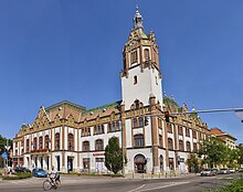
Town hall

Numerous Roman urns and other ancient relics have been dug up in the vicinity.

Conquering Hungarians arrived in the 9th century, adopted Christianity and settled down in the region by the 10th century.[3] The first settlements devastated by the Mongols in 1241–42, the region became uninhabited. King Béla IV invited Cuman settlers,[4] who also adopted Christianity, farming lifestyle and the Hungarian language.[3] The town was existing in 1389 when a document mentions Feledház, an earlier name for the settlement.[5] The town was ruined in 1526 by Ottoman troops and was uninhabited until the Christian troops liberated the area.[2][3][4]

Kiskunfélegyháza was reestablished by Roman Catholic Hungarian settlers[3] from Jászfényszaru and Üllés in 1743.[4] Queen Maria Theresa moved the courts and prisons for the Kiskun district to Kiskunfélegyháza in 1753 and granted town privileges also in 1774.[4][5]

Notable people

[edit]

Twin towns – sister cities

[edit]

Kiskunfélegyháza is twinned with:[6]

  • Germany Braunfels, Germany
  • Romania Corund, Romania
  • France Die, France
  • Italy Feltre, Italy
  • Hungary Jászfényszaru, Hungary
  • Serbia Kikinda, Serbia
  • Poland Rabka-Zdrój, Poland
  • Romania Sighișoara, Romania
  • Romania Turda, Romania
  • Slovakia Uhrovec, Slovakia
  • References

    [edit]
    1. ^ Magyarország autóatlasz, Dimap-Szarvas, Budapest, 2004, ISBN 963-03-7576-1
  • ^ a b Chisholm 1911, p. 836.
  • ^ a b c d Károly Kocsis (DSc, University of Miskolc) – Zsolt Bottlik (PhD, Budapest University) – Patrik Tátrai: Etnikai térfolyamatok a Kárpát-medence határon túli régióiban, Magyar Tudományos Akadémia (Hungarian Academy of Sciences) – Földrajtudományi Kutatóintézet (Academy of Geographical Studies); Budapest; 2006.; ISBN 963-9545-10-4, CD Atlas
  • ^ a b c d Antal Papp: Magyarország (Hungary), Panoráma, Budapest, 1982, ISBN 963 243 241 X, p. 860, pp. 405-407
  • ^ a b "Hungary, Kiskunfelegyhaza". Retrieved 20 June 2013.
  • ^ "Testvérvárosok". felegyhaziturizmus.hu (in Hungarian). Félegyházi Turizmus. Retrieved 2021-03-28.
  • [edit]
    Retrieved from "https://en.wikipedia.org/w/index.php?title=Kiskunfélegyháza&oldid=1214226809"

    Categories: 
    Populated places in Bács-Kiskun County
    Towns in Hungary
    Hidden categories: 
    Pages using gadget WikiMiniAtlas
    CS1 Hungarian-language sources (hu)
    Articles with short description
    Short description is different from Wikidata
    Coordinates on Wikidata
    Pages with Hungarian IPA
    Articles containing German-language text
    Wikipedia articles incorporating a citation from the 1911 Encyclopaedia Britannica with Wikisource reference
    Wikipedia articles incorporating text from the 1911 Encyclopædia Britannica
    Commons category link is on Wikidata
    Official website different in Wikidata and Wikipedia
    Articles with VIAF identifiers
    Articles with WorldCat Entities identifiers
    Articles with GND identifiers
    Articles with J9U identifiers
    Articles with LCCN identifiers
    Articles with NKC identifiers
    Articles with MusicBrainz area identifiers


    This page was last edited on 17 March 2024, at 17:44 (UTC).

    Text is available under the Creative Commons Attribution-ShareAlike License 4.0; additional terms may apply. By using this site, you agree to the Terms of Use and Privacy Policy. Wikipedia® is a registered trademark of the Wikimedia Foundation, Inc., a non-profit organization.


    Privacy policy

    About Wikipedia

    Disclaimers

    Contact Wikipedia

    Code of Conduct

    Developers

    Statistics

    Cookie statement

    Mobile view


    Wikimedia Foundation
    Powered by MediaWiki