Jump to content


Main menu


Navigation  


Main page
Contents
Current events
Random article
About Wikipedia
Contact us
Donate


Contribute  


Help
Learn to edit
Community portal
Recent changes
Upload file


Search  


Create account

Log in


Create account
 Log in


Pages for logged out editors learn more  


Contributions
Talk


Contents


(Top)


1 History  


2 Population  


3 Education  


4 Gallery  


5 References  


Kitanomaru Park


Cebuano
Deutsch
Español
فارسی
Français

Bahasa Melayu

Português
کوردی
Winaray


Edit links


Article
Talk


Read
Edit
View history


Tools


Actions  


Read
Edit
View history


General  


What links here
Related changes
Upload file
Special pages
Permanent link
Page information
Cite this page
Get shortened URL
Download QR code
Wikidata item


Print/export  


Download as PDF
Printable version


In other projects  


Wikimedia Commons


Appearance


From Wikipedia, the free encyclopedia


Kitanomaru Park
Map
LocationChiyoda, Tokyo, Japan
Coordinates35°41′26N 139°45′11E / 35.69043°N 139.75300°E / 35.69043; 139.75300
Area193,297 square metres (2,080,630 sq ft)
Created1969
Operated byMinistry of the Environment

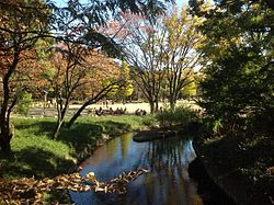
Kitanomaru Park (北の丸公園, Kitanomaru Kōen) is a public park in Chiyoda, central Tokyo, Japan, just north of the Tokyo Imperial Palace. It is the location of the Nippon Budokan indoor sports and performance venue, the Science Museum, and the National Museum of Modern Art, Tokyo.

History[edit]

Kitanomaru Park was originally the northernmost section of Edo Castle, known as the Kitanomaru (北の丸, northern enceinte). It was used as a medicinal garden and as a secure residential compound for members of the Tokugawa extended family. The park is almost encircled by deep moats and defensive fortifications from the original castle.

Prior to 1969, when Kitanomaru Park was opened, this district had been called Daikanchō (代官町, literal translation: Town of Local Governors) because many daikan (local governors) lived in the place soon after the construction of Edo Castle. Today, the name Daikanchō is known more commonly as the name of an interchange of the Inner Circular Route of the Shuto Expressway.

Two gated entrances survive from time of Edo Castle, the Tayasu-mon and the Shimizu-mon. The Tayasu-mon was the northernmost gate of Edo Castle and consists of both a Korai-mon style outer gate and a Yagura-mon style fortified inner gatehouse, with highly stacked stone walls forming a narrow defensive courtyard between the two. An inscription on the outer side of the Tayasu-mon states the gate was constructed in 1685, making it one of the oldest surviving structures of the original castle.

Population[edit]

As of May 1, 2008, Kitanomaru Park area had a registered population of 598, of which 361 are male and 237 are female, although this population almost exclusively consists of serving members and dependents of the Imperial Guard or the National Police Agency.[1]

Education[edit]

Chiyoda Board of Education [ja] operates public elementary and junior high schools. Fujimi Elementary School (富士見小学校) is the zoned elementary school for Kitanomaru Park.[2] There is freedom of choice system for junior high schools in Chiyoda Ward, and so there are no specific junior high school zones.[3]

Gallery[edit]

References[edit]

  1. ^ 千代田区区民生活部総合窓口課. "町丁別世帯数および人口(住民基本台帳):平成2051日現在". Archived from the original on 2008-05-17. Retrieved 2008-05-08.
  • ^ "区立小学校の通学区域". Chiyoda Board of Education. Retrieved 2022-10-08.
  • ^ "区立中学校の通学区域と学校選択". Chiyoda Board of Education. Retrieved 2022-10-08. 千代田区では、[...]

  • Retrieved from "https://en.wikipedia.org/w/index.php?title=Kitanomaru_Park&oldid=1222262086"

    Categories: 
    Parks and gardens in Tokyo
    Chiyoda, Tokyo
    Tokyo Imperial Palace
    Hidden categories: 
    Articles with short description
    Short description is different from Wikidata
    Pages using gadget WikiMiniAtlas
    Articles containing Japanese-language text
    Commons category link is on Wikidata
    Articles with VIAF identifiers
    Articles with NDL identifiers
    Articles with MusicBrainz area identifiers
    Pages using the Kartographer extension


    This page was last edited on 4 May 2024, at 22:10 (UTC).

    Text is available under the Creative Commons Attribution-ShareAlike License 4.0; additional terms may apply. By using this site, you agree to the Terms of Use and Privacy Policy. Wikipedia® is a registered trademark of the Wikimedia Foundation, Inc., a non-profit organization.


    Privacy policy

    About Wikipedia

    Disclaimers

    Contact Wikipedia

    Code of Conduct

    Developers

    Statistics

    Cookie statement

    Mobile view


    Wikimedia Foundation
    Powered by MediaWiki