Jump to content


Main menu


Navigation  


Main page
Contents
Current events
Random article
About Wikipedia
Contact us
Donate


Contribute  


Help
Learn to edit
Community portal
Recent changes
Upload file


Search  


Create account

Log in


Create account
 Log in


Pages for logged out editors learn more  


Contributions
Talk


Contents


(Top)


1 Location  


2 Description  


3 Monument record  


4 References  


Knag Burn Gateway


Add links


Article
Talk


Read
Edit
View history


Tools


Actions  


Read
Edit
View history


General  


What links here
Related changes
Upload file
Special pages
Permanent link
Page information
Cite this page
Get shortened URL
Download QR code
Wikidata item


Print/export  


Download as PDF
Printable version


In other projects  


Wikimedia Commons


Appearance


Coordinates: 55°0053N 2°1943W / 55.01466°N 2.32865°W / 55.01466; -2.32865
 

From Wikipedia, the free encyclopedia


Knag Burn Gateway
Northumberland, England, UK
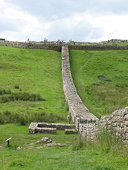
Remains of the Knag Burn Gateway taken from South of the wall facing West towards Housesteads (visible at the top of the hill)
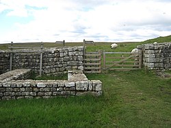
The remains of the gateway
Knag Burn Gateway is located in Northumberland
Knag Burn Gateway

Knag Burn Gateway

Location in Northumberland

Coordinates55°00′53N 2°19′43W / 55.01466°N 2.32865°W / 55.01466; -2.32865
Grid referenceNY79086894

The Knag Burn Gateway is a gateway which was built into Hadrian's Wall some time after construction of the wall itself, generally acknowledged to be during the fourth century.[1]

Location

[edit]

Knag Burn Gateway is located at the point where Hadrian's Wall crosses the Knag Burn, just to the east of Housesteads, between the fort and Turret 36B. The burn itself passes beneath the wall via a culvert a few metres to the West of the gateway.

Description

[edit]

Knag Burn Gateway is one of the few gates through the wall that isn't part of a milecastleorfort.[1] The remains indicate that the structure consisted of a single-lane gateway, with guard-chambers on either side and a gate at each end, thus allowing two-stage controlled passage through the wall.[2] Professor I. A. Richmond suggested that the gateway was constructed to allow trade traffic through the wall some time in or after the fourth century.[3]

The gateway was discovered in 1855 and excavated in 1936 and 1988. The structure consists of the 3.7 metres (12 ft) wide gateway with two small structures either side.[4]

The two cell structures at either side of the gateway measure 4.65 metres (15.3 ft) by 3.25 metres (10.7 ft), with entrances 0.95 metres (3 ft 1 in) wide (on the side nearest the gateway), which open onto a passage.[4]

Monument record

[edit]
Monument Monument Number English Heritage Archive Number Scheduled Monument Notification
Knag Burn Gateway 1007856 NY 76 NE 95 14-July-1997

References

[edit]
  1. ^ a b Breeze, David J (1934), Handbook to the Roman Wall (14th Revised edition - Nov 2006), Society of Antiquaries of Newcastle upon Tyne, ISBN 0-901082-65-1
  • ^ David J Breeze and Brian Dobson (1976). Hadrian's Wall. Allen Lane. ISBN 0-14-027182-1.
  • ^ Toynbee, J. M. C. (June 1960). "Review: The Impact of Roman on Native in North Britain". The Classical Review. 10 (2). Cambridge University Press: 164–166. doi:10.1017/s0009840x0017074x.
  • ^ a b "Knag Burn Gateway". Pastscape. English Heritage. Retrieved 11 May 2010.

  • Retrieved from "https://en.wikipedia.org/w/index.php?title=Knag_Burn_Gateway&oldid=1209922296"

    Categories: 
    Hadrian's Wall
    Roman sites in Northumberland
    History of Northumberland
    Hidden categories: 
    Pages using gadget WikiMiniAtlas
    Articles with short description
    Short description matches Wikidata
    Use dmy dates from April 2022
    Coordinates on Wikidata
    Articles with OS grid coordinates


    This page was last edited on 24 February 2024, at 04:43 (UTC).

    Text is available under the Creative Commons Attribution-ShareAlike License 4.0; additional terms may apply. By using this site, you agree to the Terms of Use and Privacy Policy. Wikipedia® is a registered trademark of the Wikimedia Foundation, Inc., a non-profit organization.


    Privacy policy

    About Wikipedia

    Disclaimers

    Contact Wikipedia

    Code of Conduct

    Developers

    Statistics

    Cookie statement

    Mobile view


    Wikimedia Foundation
    Powered by MediaWiki