Jump to content


Main menu


Navigation  


Main page
Contents
Current events
Random article
About Wikipedia
Contact us
Donate


Contribute  


Help
Learn to edit
Community portal
Recent changes
Upload file


Search  


Create account

Log in


Create account
 Log in


Pages for logged out editors learn more  


Contributions
Talk


Contents


(Top)


1 See also  


2 References  


3 External links  


Kohtla-Nõmme


 / Bân-lâm-gú
Беларуская
Cebuano
Čeština
Deutsch
Eesti
Español
فارسی
Français
Հայերեն
Italiano

Nederlands
Oʻzbekcha / ўзбекча
Português
Русский
Scots
Suomi
Svenska
Українська
Volapük
 

Edit links


Article
Talk


Read
Edit
View history


Tools


Actions  


Read
Edit
View history


General  


What links here
Related changes
Upload file
Special pages
Permanent link
Page information
Cite this page
Get shortened URL
Download QR code
Wikidata item


Print/export  


Download as PDF
Printable version


In other projects  


Wikimedia Commons


Appearance


Coordinates: 59°2114N 27°1131E / 59.35389°N 27.19194°E / 59.35389; 27.19194
 

From Wikipedia, the free encyclopedia


Kohtla-Nõmme
Borough with a municipality status
Flag of Kohtla-Nõmme
Coat of arms of Kohtla-Nõmme
Kohtla-Nõmme is located in Estonia
Kohtla-Nõmme

Kohtla-Nõmme

Location in Estonia

Coordinates: 59°21′14N 27°11′31E / 59.35389°N 27.19194°E / 59.35389; 27.19194
CountryEstonia
CountyIda-Viru County
MunicipaityToila Parish
Area
 • Total4.64 km2 (1.79 sq mi)
Population
 (01.01.2009)
 • Total1,047
 • Density230/km2 (580/sq mi)

Kohtla-Nõmme is a borough (Estonian: alev) in Toila Parish, in Ida-Viru County, in northeastern Estonia. It had a population of 1,047 (as of 1 January 2009) and an area of 4.64 km².[1]

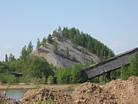
In the 1930s, New Consolidated Gold Fields opened a shale oil extraction complex at Kohtla-Nõmme. In 1937, the company opened the Kohtla underground mine. After the occupation of Estonia by the Soviet Union, the company was nationalized in 1940. The Kohtla-Nõmme shale oil extraction complex continued to operate until 1961. The underground mine stayed operational until 2001.[2] After that the Estonian Mining Museum was opened at the site.

See also

[edit]

References

[edit]
  1. ^ "Population figure and composition". stat.ee – Statistics Estonia. Retrieved 29 January 2010.
  • ^ Karu, Veiko; Valgma, Ingo; Kolats, Margit (2013). "Mine water as a potential source of energy from underground mined area in Estonian oil shale deposit" (PDF). Oil Shale. A Scientific-Technical Journal. 30 (2S). Estonian Academy Publishers: 336–362. doi:10.3176/oil.2013.2S.12. ISSN 0208-189X. Retrieved 2014-04-12.
  • [edit]
  • t
  • e

  • Retrieved from "https://en.wikipedia.org/w/index.php?title=Kohtla-Nõmme&oldid=1222644644"

    Categories: 
    Toila Parish
    Ida-Viru County geography stubs
    Boroughs and small boroughs in Estonia
    Former municipalities of Estonia
    Populated places in Ida-Viru County
    Hidden categories: 
    Pages using gadget WikiMiniAtlas
    Articles with short description
    Short description is different from Wikidata
    Coordinates on Wikidata
    Articles containing Estonian-language text
    All stub articles


    This page was last edited on 7 May 2024, at 03:04 (UTC).

    Text is available under the Creative Commons Attribution-ShareAlike License 4.0; additional terms may apply. By using this site, you agree to the Terms of Use and Privacy Policy. Wikipedia® is a registered trademark of the Wikimedia Foundation, Inc., a non-profit organization.


    Privacy policy

    About Wikipedia

    Disclaimers

    Contact Wikipedia

    Code of Conduct

    Developers

    Statistics

    Cookie statement

    Mobile view


    Wikimedia Foundation
    Powered by MediaWiki