Jump to content


Main menu


Navigation  


Main page
Contents
Current events
Random article
About Wikipedia
Contact us
Donate


Contribute  


Help
Learn to edit
Community portal
Recent changes
Upload file


Search  


Create account

Log in


Create account
 Log in


Pages for logged out editors learn more  


Contributions
Talk


Contents


(Top)


1 References  


Koohrang


تۆرکجه
فارسی
پنجابی
اردو
 

Edit links


Article
Talk


Read
Edit
View history


Tools


Actions  


Read
Edit
View history


General  


What links here
Related changes
Upload file
Special pages
Permanent link
Page information
Cite this page
Get shortened URL
Download QR code
Wikidata item


Print/export  


Download as PDF
Printable version


Appearance


Coordinates: 32°0853.96N 50°2607.57E / 32.1483222°N 50.4354361°E / 32.1483222; 50.4354361 (Koohran River mouth)
 

From Wikipedia, the free encyclopedia


Koohrang

Location

Country

Iran

Physical characteristics

Mouth


 • location

Karun River

Basin features

River system

Karun River

Semirom dam

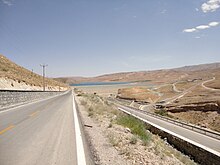
The Koohrang (also known as Kouhrang and Kurang) is a river originating in the Zagros mountains of western Iran, which joins the Beheštābād river (32°00′44N 50°36′37E / 32.01222°N 50.61028°E / 32.01222; 50.61028) to form the Karun, Iran's largest (by volume) river. A series of tunnels (Kuhrang Tunnels) have been built since the 1950s to redirect some of the Kuhrang's water toward the Zayandeh River to meet the demands of increased population in Esfahan and Yazd provinces.

The Zayandeh River basin encompasses about 41,500 square kilometres (16,000 sq mi) and is connected to the upper Karun River basin (which drains to the Persian Gulf) by the Kuhrang Dam and Tunnel 1 (32°26′10.94″N 50°06′04.50″E / 32.4363722°N 50.1012500°E / 32.4363722; 50.1012500 (Koorang Dam and Tunnel 1)) constructed in 1953 although first proposed in the early sixteenth century. Two additional tunnels (Kurang 2 and Kurang 3) were constructed in late 1990s and early 2000s. A hydroelectric dam at Godar-e Langar (also known as Karun-4) would also supply piped water to Esfahan 300 kilometres (190 mi) away if it is completed (Whitley and Gallagher, 1995). Dams have deleterious effects on a riverine fish and other fauna and are often stocked with exotic species. The upper Karun has not been well explored for endemic taxa. Mean annual flow of the Zayandeh River is estimated at 1.2 to 1.45 cubic kilometres (970,000 to 1,180,000 acre⋅ft) and is used mostly for agriculture, but an increase in population and industry has necessitated dam construction (Chadegan Reservoir, capacity 1.45 cubic kilometres (0.35 cu mi)) and diversion schemes. There is also the Hana Dam on the Hana River at Semirom with a height of 35 metres (115 ft) and a capacity of 45 million cubic metres (1.6×10⁹ cu ft).[1]

References[edit]

  1. ^ "Freshwater Fishes of Iran, Introduction - Drainage Basins - Esfahan".

32°08′53.96″N 50°26′07.57″E / 32.1483222°N 50.4354361°E / 32.1483222; 50.4354361 (Koohran River mouth)

Lake Urmia basin

  • Alamlou River
  • Barandouz River
  • Gadar River
  • Ghaie River
  • Leylan River
  • Mahabad River
  • Nazlou River
  • Rozeh River
  • Shahar River
  • Simineh River
  • Zarrineh River
  • Saqqez River
  • Zola River
  • Persian Gulf basin

  • Dez River
  • Jarahi River
  • Bahmanshir
  • Mehran River
  • Mond River
  • Oman sea basin

    Caspian basin

  • Sefid-Rud
  • Chalus River
  • Haraz River
  • Atrek River
  • Kojoor River
  • Do Hezar River
  • Atrek River
  • Qarasu River
  • Gorganrud River
  • Astarachay
  • Gavkhouni basin

    Namak Lake basin

  • Abhar River
  • Jajrud
  • Karaj River
  • Hamun-e Jaz Murian basin

  • Bampur River
  • Other


  • t
  • e

  • Retrieved from "https://en.wikipedia.org/w/index.php?title=Koohrang&oldid=1228941550"

    Categories: 
    Rivers of Chaharmahal and Bakhtiari province
    Chaharmahal and Bakhtiari province
    Khuzestan province
    Iran river stubs
    Hidden categories: 
    Pages using gadget WikiMiniAtlas
    Articles with short description
    Short description matches Wikidata
    Coordinates on Wikidata
    All stub articles


    This page was last edited on 14 June 2024, at 01:12 (UTC).

    Text is available under the Creative Commons Attribution-ShareAlike License 4.0; additional terms may apply. By using this site, you agree to the Terms of Use and Privacy Policy. Wikipedia® is a registered trademark of the Wikimedia Foundation, Inc., a non-profit organization.


    Privacy policy

    About Wikipedia

    Disclaimers

    Contact Wikipedia

    Code of Conduct

    Developers

    Statistics

    Cookie statement

    Mobile view


    Wikimedia Foundation
    Powered by MediaWiki