Jump to content


Main menu


Navigation  


Main page
Contents
Current events
Random article
About Wikipedia
Contact us
Donate


Contribute  


Help
Learn to edit
Community portal
Recent changes
Upload file


Search  


Create account

Log in


Create account
 Log in


Pages for logged out editors learn more  


Contributions
Talk


Contents


(Top)


1 Population  


2 Notable people  


3 References  


4 External links  


Kopstal


Alemannisch
 / Bân-lâm-gú
Беларуская
Беларуская (тарашкевіца)
Català
Cebuano
Dansk
Deutsch
فارسی
Français
Italiano
Lëtzebuergesch
Limburgs
Bahasa Melayu
Nederlands
Norsk bokmål
Plattdüütsch
Polski
Português
Русский
Simple English
Slovenčina
Svenska
Türkçe
Українська


Edit links


Article
Talk


Read
Edit
View history


Tools


Actions  


Read
Edit
View history


General  


What links here
Related changes
Upload file
Special pages
Permanent link
Page information
Cite this page
Get shortened URL
Download QR code
Wikidata item


Print/export  


Download as PDF
Printable version


In other projects  


Wikimedia Commons


Appearance


Coordinates: 49°3951N 6°0419E / 49.664167°N 6.071944°E / 49.664167; 6.071944
 

From Wikipedia, the free encyclopedia


Kopstal
Koplescht (Luxembourgish)
The town hall
The town hall
Coat of arms of Kopstal
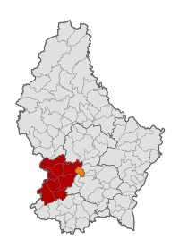
Map of Luxembourg with Kopstal highlighted in orange, and the canton in dark red
Coordinates: 49°39′51N 6°04′19E / 49.664167°N 6.071944°E / 49.664167; 6.071944
Country Luxembourg
CantonCapellen
Area
 • Total7.9 km2 (3.1 sq mi)
 • Rank97th of 100
Highest elevation
392 m (1,286 ft)
 • Rank59th of 100
Lowest elevation
245 m (804 ft)
 • Rank55th of 100
Population
 (2023)
 • Total4,286
 • Rank43rd of 100
 • Density540/km2 (1,400/sq mi)
  • Rank17th of 100
Time zoneUTC+1 (CET)
 • Summer (DST)UTC+2 (CEST)
LAU 2LU0000107
Websitekopstal.lu

Kopstal (Luxembourgish: Koplescht) is a commune and a small town in central Luxembourg. The towns of Kopstal and Bridel belong to this commune. Kopstal is a small town, with a population of 1,045 as of 2023,[1] located in a valley between forested hills situated beneath Bridel.

Kopstal was formed on 1 July 1853, when it was detached from the communes of Kehlen (inCapellen canton) and Steinsel (inLuxembourg canton). The law forming Kopstal was passed on the 22 February 1853.[2]

Population[edit]

[3]

Notable people[edit]

References[edit]

  1. ^ "Registre national des personnes physiques RNPP : Population par localité". data.public.lu. 2024-01-07.
  • ^ (in French and German) "Mémorial A, 1853, No. 31" (PDF). Service central de législation. Retrieved 2006-08-15.[permanent dead link]
  • ^ "Population par canton et commune". statistiques.public.lu. Archived from the original on 12 September 2016. Retrieved 11 January 2022.
  • External links[edit]


  • t
  • e

  • Retrieved from "https://en.wikipedia.org/w/index.php?title=Kopstal&oldid=1232396919"

    Categories: 
    Kopstal
    Communes in Capellen (canton)
    Towns in Luxembourg
    Luxembourg geography stubs
    Hidden categories: 
    Pages using gadget WikiMiniAtlas
    Pages using the Graph extension
    Pages with disabled graphs
    Articles with French-language sources (fr)
    Articles with German-language sources (de)
    All articles with dead external links
    Articles with dead external links from May 2023
    Articles with permanently dead external links
    Articles with short description
    Short description is different from Wikidata
    Articles containing Luxembourgish-language text
    Coordinates on Wikidata
    Commons category link from Wikidata
    Articles with VIAF identifiers
    Articles with GND identifiers
    Articles with SUDOC identifiers
    All stub articles


    This page was last edited on 3 July 2024, at 14:44 (UTC).

    Text is available under the Creative Commons Attribution-ShareAlike License 4.0; additional terms may apply. By using this site, you agree to the Terms of Use and Privacy Policy. Wikipedia® is a registered trademark of the Wikimedia Foundation, Inc., a non-profit organization.


    Privacy policy

    About Wikipedia

    Disclaimers

    Contact Wikipedia

    Code of Conduct

    Developers

    Statistics

    Cookie statement

    Mobile view


    Wikimedia Foundation
    Powered by MediaWiki