Jump to content


Main menu


Navigation  


Main page
Contents
Current events
Random article
About Wikipedia
Contact us
Donate


Contribute  


Help
Learn to edit
Community portal
Recent changes
Upload file


Search  


Create account

Log in


Create account
 Log in


Pages for logged out editors learn more  


Contributions
Talk


Contents


(Top)


1 Villages  


2 Population history  


3 History  


4 References  


5 Sources  


6 External links  


Kouoro


 / Bân-lâm-gú
Español
Français
Italiano
Nederlands
Português
Suomi


Edit links


Article
Talk


Read
Edit
View history


Tools


Actions  


Read
Edit
View history


General  


What links here
Related changes
Upload file
Special pages
Permanent link
Page information
Cite this page
Get shortened URL
Download QR code
Wikidata item


Print/export  


Download as PDF
Printable version


Appearance


Coordinates: 11°585N 5°4119W / 11.96806°N 5.68861°W / 11.96806; -5.68861
 

From Wikipedia, the free encyclopedia


Kouoro
Commune and town
Kouoro is located in Mali
Kouoro

Kouoro

Location in Mali

Coordinates: 11°58′5N 5°41′19W / 11.96806°N 5.68861°W / 11.96806; -5.68861
Country Mali
RegionSikasso Region
CercleSikasso Cercle
Area
 • Total472 km2 (182 sq mi)
Elevation
300 m (1,000 ft)
Population
 (2023 census)[2]
 • Total23,169
 • Density49/km2 (130/sq mi)
Time zoneUTC+0 (GMT)

Kouoro is a small town and rural commune in the Cercle of Kléla in the Sikasso Region of southern Mali. The commune covers an area of 472 square kilometers and includes the town and five villages.[3] In the 2023 census it had a population of 23169.[2] The town of Kouoro, the chef-lieu of the commune, is 80 km north of Sikasso, just off of the RN11, the main road linking Sikasso and Koutiala. It is also about 30 km west of the border with Burkina Faso.

Villages[edit]

Population history[edit]

Historical population
YearPop.±%
1998
(census)
10,782—    
2009
(estimate)
11,315+4.9%

History[edit]

The French explorer René Caillié stopped at Kouoro in February 1828 on his journey to Timbuktu. He was travelling with a caravan transporting kola nutstoDjenné. In his book Travels through Central Africa to Timbuctoo published in 1830, he refers to what was then a village as Couara.[4] Caillié wrote:

At nine o'clock in the morning we halted at Couara, a pretty village, where we found an abundance of all the necessities of life. The inhabitants grow a great deal of cotton and millet, and are supplied with water from a stream that runs E.N.E., half a mile from the village.[5]

What Caillié referred to as a stream was actually the Banifing River, a tributary of the Bani but in February it would have had very little water.[4]

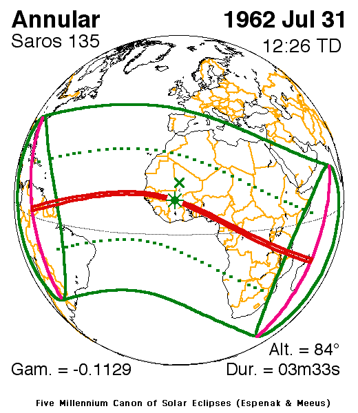
Not long after Mali declared independence from France in 1960, an annular solar eclipse took place on 31 July 1962, some 4 km northwest was the center of the greatest eclipse that happened at 12:25 GMT and 12 N, 5.7 W and included Kouoro and lasted for 3+12 minutes.[6]

In 2017 a new road bridge over the Banifing opened to replace one built in 1963 that, due to its design and age, could not handle the amount of traffic on the modern RN11.[7]

References[edit]

  1. ^ Common and Fundamental Operational Datasets Registry: Mali, United Nations Office for the Coordination of Humanitarian Affairs, archived from the original on January 6, 2012. commune_mali.zip (Originally from the Direction Nationale des Collectivités Territoriales, République du Mali)
  • ^ a b Resultats Provisoires RGPH 2023 (Région de Sikasso) (PDF) (in French), République de Mali: Institut National de la Statistique, archived from the original (PDF) on July 27, 2012.
  • ^ Communes de la Région de Sikasso (PDF) (in French), Ministère de l’administration territoriale et des collectivités locales, République du Mali, archived from the original (PDF) on 2013-12-03.
  • ^ a b Viguier 2008, p. 52.
  • ^ Caillié 1830, p. 415.
  • ^ "Solar eclipse of July 31, 1962". NASA. Retrieved March 21, 2017.
  • ^ Sasuke (2017-11-29). "KOUORO BARRAGE :LE PONT INAUGURÉ…FIN DE CALVAIRE POUR LES USAGERS DE L'AXE SIKASSO-KOUTIALA". Bamada.net. Retrieved 14 March 2023.
  • Sources[edit]

    External links[edit]


  • t
  • e

  • Retrieved from "https://en.wikipedia.org/w/index.php?title=Kouoro&oldid=1198228951"

    Categories: 
    Communes of Sikasso Region
    Sikasso Region geography stubs
    Hidden categories: 
    Pages using gadget WikiMiniAtlas
    CS1 French-language sources (fr)
    Articles with short description
    Short description matches Wikidata
    Coordinates on Wikidata
    All stub articles


    This page was last edited on 23 January 2024, at 14:17 (UTC).

    Text is available under the Creative Commons Attribution-ShareAlike License 4.0; additional terms may apply. By using this site, you agree to the Terms of Use and Privacy Policy. Wikipedia® is a registered trademark of the Wikimedia Foundation, Inc., a non-profit organization.


    Privacy policy

    About Wikipedia

    Disclaimers

    Contact Wikipedia

    Code of Conduct

    Developers

    Statistics

    Cookie statement

    Mobile view


    Wikimedia Foundation
    Powered by MediaWiki