Jump to content


Main menu


Navigation  


Main page
Contents
Current events
Random article
About Wikipedia
Contact us
Donate


Contribute  


Help
Learn to edit
Community portal
Recent changes
Upload file


Search  


Create account

Log in


Create account
 Log in


Pages for logged out editors learn more  


Contributions
Talk


Contents


(Top)


1 Etymology  


2 Geography  


3 History  


4 Symbols  


5 Administration  


5.1  Central administration  


5.2  Local administration  


6 References  


7 External links  


Kumphawapi district


 / Bân-lâm-gú
Cebuano
Deutsch

িি ি
Bahasa Indonesia
Italiano
Română

Tiếng Vit
 

Edit links


Article
Talk


Read
Edit
View history


Tools


Actions  


Read
Edit
View history


General  


What links here
Related changes
Upload file
Special pages
Permanent link
Page information
Cite this page
Get shortened URL
Download QR code
Wikidata item


Print/export  


Download as PDF
Printable version


Appearance


Coordinates: 17°650N 103°17E / 17.11389°N 103.01861°E / 17.11389; 103.01861
 

From Wikipedia, the free encyclopedia
 

(Redirected from Kumphawapi District)

Kumphawapi
กุมภวาปี
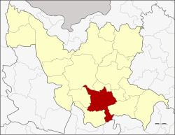
District location in Udon Thani province
Coordinates: 17°6′50N 103°1′7E / 17.11389°N 103.01861°E / 17.11389; 103.01861
CountryThailand
ProvinceUdon Thani
SeatKumphawapi
Area
 • Total672.6 km2 (259.7 sq mi)
Population
 (2017)
 • Total124,241
 • Density187.6/km2 (486/sq mi)
Time zoneUTC+7 (ICT)
Postal code41110
Geocode4104

Kumphawapi (Thai: กุมภวาปี, pronounced [kūm.pʰā.wāː.pīː]; Northeastern Thai: กุมภวาปี, pronounced [kūm.phā.wa᷇ː.pīː]) is a district (amphoe) in the southern part of Udon Thani province, northeastern Thailand.

Etymology

[edit]

Kumpha กุมภ[า] is from Sanskrit 'pitcher' or 'water-pot', as reflected in the name of February, associated with the zodiac sign of Aquarius. Wapi วาปี is from Sanskrit 'pond', synonymous with หนองนํ้า, บึง.[1]

Geography

[edit]

Neighboring districts are (from the southwest clockwise): Non Sa-at, Nong Saeng, Mueang Udon Thani, Prachaksinlapakhom, Ku Kaeo and Si That of Udon Thani Province; Tha KhanthoofKalasin province and KranuanofKhon Kaen province.

North of the central town is the shallow Nong Han Kumphawapi Lake. The lake is surrounded by marshland, one of the largest natural wetlands in northeast Thailand. The lake is drained by Lam Pao.

History

[edit]

Mueang Kumphawapi was one of the four original subdivisions of Udon Thani, which were converted into amphoes during the thesaphiban administrative reforms in 1908.[2]

Symbols

[edit]

The district slogan is "Kumphawapi, city of sugar, monkey park, highland of glass Buddha station, goose wetland stream of life."

Administration

[edit]

Central administration

[edit]

Kumphawapi is divided into 13 sub-districts (tambons), which are further subdivided into 176 administrative villages (mubans).

No. Name Thai Villages Pop.[3]
01. Tum Tai ตูมใต้ 09 07,042
02. Phan Don พันดอน 20 17,410
03. Wiang Kham เวียงคำ 18 10,496
04. Chaelae แชแล 14 10,311
06. Chiang Wae เชียงแหว 13 08,633
07. Huai Koeng ห้วยเกิ้ง 08 05,424
09. Soephloe เสอเพลอ 19 11,959
10. Si O สีออ 08 04,546
11. Pakho ปะโค 17 11,304
13. Pha Suk ผาสุก 10 06,379
14. Tha Li ท่าลี่ 14 09,775
15. Kumphawapi กุมภวาปี 15 12,890
16. Nong Wa หนองหว้า 11 08,072

Missing numbers are tambon which now form Prachak Sinlapakhom District.

Local administration

[edit]

There are nine sub-district municipalities (thesaban tambons) in the district:

There are six subdistrict administrative organizations (SAO) in the district:

References

[edit]
  • ^ แจ้งความกระทรวงมหาดไทย เรื่อง ให้รวมเมืองกมุทธาไส ๑ เมือง กุมภวาปี ๑ เมือง หนองหาย ๑ อำเภอ บ้านหมากแข้ง ๑ ตั้งเป็นเมืองจัตวา เรียกว่าเมืองอุดรธานีบริเวณน้ำชีให้เปลี่ยนเรียกว่าเมืองขอนแก่น บริเวณน้ำเหืองให้เปลี่ยนเรียกว่าเมืองเลย บริเวณสกลนครให้เปลี่ยน เรียกว่าเมืองสกลนคร บริเวณธาตุพนมให้เปลี่ยนเรียกว่าเมืองนครพนม ส่วนเมืองหนองคายเมืองโพนพิสัยให้คงไว้ตามเดิม (PDF). Royal Gazette (in Thai). 24 (41): 1088. 1908-01-12. Archived from the original (PDF) on January 25, 2012.
  • ^ "Population statistics 2017" (in Thai). Department of Provincial Administration. Retrieved 2018-03-13.
  • [edit]


  • t
  • e

  • Retrieved from "https://en.wikipedia.org/w/index.php?title=Kumphawapi_district&oldid=1226999787"

    Categories: 
    Districts of Udon Thani province
    Isan geography stubs
    Hidden categories: 
    Pages using gadget WikiMiniAtlas
    Webarchive template wayback links
    CS1 uses Thai-language script (th)
    CS1 Thai-language sources (th)
    Articles with short description
    Short description is different from Wikidata
    Coordinates on Wikidata
    Articles containing Thai-language text
    Pages with Thai IPA
    Articles containing Northeastern Thai-language text
    Pages with Lao IPA
    Articles with VIAF identifiers
    Articles with WorldCat Entities identifiers
    Articles with J9U identifiers
    Articles with LCCN identifiers
    All stub articles


    This page was last edited on 3 June 2024, at 01:40 (UTC).

    Text is available under the Creative Commons Attribution-ShareAlike License 4.0; additional terms may apply. By using this site, you agree to the Terms of Use and Privacy Policy. Wikipedia® is a registered trademark of the Wikimedia Foundation, Inc., a non-profit organization.


    Privacy policy

    About Wikipedia

    Disclaimers

    Contact Wikipedia

    Code of Conduct

    Developers

    Statistics

    Cookie statement

    Mobile view


    Wikimedia Foundation
    Powered by MediaWiki