Jump to content


Main menu


Navigation  


Main page
Contents
Current events
Random article
About Wikipedia
Contact us
Donate


Contribute  


Help
Learn to edit
Community portal
Recent changes
Upload file


Search  


Create account

Log in


Create account
 Log in


Pages for logged out editors learn more  


Contributions
Talk


Contents


(Top)


1 Origin and course of flow  


2 See also  


3 References  


4 Further reading  


Kunar River


العربية
تۆرکجه

Чӑвашла
Cebuano
Cymraeg
Deutsch
Ελληνικά
Español
فارسی
Français
ि
Italiano
Latviešu
Lietuvių
Magyar

مصرى
Oʻzbekcha / ўзбекча

پنجابی
Polski
Português
Русский
Simple English
سنڌي
Svenska
Тоҷикӣ
اردو


Edit links


Article
Talk


Read
Edit
View history


Tools


Actions  


Read
Edit
View history


General  


What links here
Related changes
Upload file
Special pages
Permanent link
Page information
Cite this page
Get shortened URL
Download QR code
Wikidata item


Print/export  


Download as PDF
Printable version


In other projects  


Wikimedia Commons


Appearance


Coordinates: 34°2408N 70°3212E / 34.4021°N 70.5367°E / 34.4021; 70.5367
 

From Wikipedia, the free encyclopedia


Kunar
Mastuj, Chitral, Kama
Course of the Kunar
Location
CountriesAfghanistan and Pakistan
ProvincesKhyber Pakhtunkhwa (Pakistan)
  • Kunar
  • Nangarhar
  • (Afghanistan)
    Physical characteristics
    SourceHindu Kush Mountains
    MouthKabul River

     • location

    Jalalabad
    Length480 km (300 mi)
    Basin size26,000 km2 (10,000 sq mi)
    Basin features
    Tributaries 
     • leftShishi River
     • rightLotkoh River, Landai Sin River, Pech River

    The Kūnaṛ River (Pashto: د کونړ سيند; Dari: رودخانه کنر; Khowar: کونڑ سيند), also known as the Chitral River (Urdu: دریائے چترال), Mastuj River (Pashto: مستوج سيند) and Kaama River (Khowar: کامې سيند), is a 480 kilometres (300 mi) long river in northern Pakistan and eastern Afghanistan. It originates just south of the Broghil Pass, in the Upper Chitral DistrictofKhyber Pakhtunkhwa province in Pakistan. It later merges with Kabul river in the Nangahar Province of Afghanistan. The river system is fed by melting glaciers and snow of the Hindu Kush mountains. The Kunar River is a tributary of the Kabul river, which is in turn a tributary of the Indus River.[1]

    Origin and course of flow[edit]

    The river rises in the far north glaciated Hindu Kush mountains of Chitral, Pakistan, where it is referred to as Chitral river.[2] Around 60% to 70% of annual discharge of Kunar river originates from Chitral.[3] Downstream as far as the town of Mastuj, it is called as the Mastuj river, till its confluence with the Lotkoh river.[4] Kunar then turns southwards into the upper Kunar Valley of Afghanistan. At the confluence in Asadabad, it meets with Pech River and finally empties into the Kabul River just to the east of the city of Jalalabad in Afghanistan.[2] The combined rivers then flow eastwards into Pakistan again, and joins the Indus River at the city of Attock.[2]

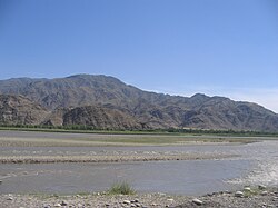
    Kunar river in the Kunar valley, Afghanistan

    See also[edit]

    References[edit]

    1. ^ The Afghan War, 1838-1842: From the Journal and Correspondence of the Late Major-General Augustus Abbott, editor Charles Rathbone Low, publisher R. Bentley & Son, 1879, Google Books
  • ^ a b c Ahmad, Mahmood (2023-09-26). Water Policy in Pakistan: Issues and Options. Springer Nature. p. 327. ISBN 978-3-031-36131-9.
  • ^ Watto, Muhammad Arif; Mitchell, Michael; Bashir, Safdar (2021-03-25). Water Resources of Pakistan: Issues and Impacts. Springer Nature. p. 45. ISBN 978-3-030-65679-9.
  • ^ Pakistan & the Karakoram. Lonely Planet. 2008. p. 233. ISBN 9781741045420.
  • Further reading[edit]

    34°24′08N 70°32′12E / 34.4021°N 70.5367°E / 34.4021; 70.5367


    Retrieved from "https://en.wikipedia.org/w/index.php?title=Kunar_River&oldid=1226083119"

    Categories: 
    Rivers of Afghanistan
    Rivers of Khyber Pakhtunkhwa
    Kabul River
    Landforms of Nuristan Province
    Landforms of Kunar Province
    Landforms of Nangarhar Province
    Chitral
    Upper Chitral District
    International rivers of Asia
    Rivers of Pakistan
    Hidden categories: 
    Pages using gadget WikiMiniAtlas
    Articles with short description
    Short description matches Wikidata
    Articles containing Pashto-language text
    Articles containing Dari-language text
    Articles containing Khowar-language text
    Articles containing Urdu-language text
    Articles with VIAF identifiers
    Articles with J9U identifiers
    Articles with LCCN identifiers
    Coordinates on Wikidata


    This page was last edited on 28 May 2024, at 13:28 (UTC).

    Text is available under the Creative Commons Attribution-ShareAlike License 4.0; additional terms may apply. By using this site, you agree to the Terms of Use and Privacy Policy. Wikipedia® is a registered trademark of the Wikimedia Foundation, Inc., a non-profit organization.


    Privacy policy

    About Wikipedia

    Disclaimers

    Contact Wikipedia

    Code of Conduct

    Developers

    Statistics

    Cookie statement

    Mobile view


    Wikimedia Foundation
    Powered by MediaWiki