
Kundian
كندياں
Mohalla Mominpura
| |
|---|---|
City and union council
| |
| Country | Pakistan |
| Region | Punjab |
| District | Mianwali District |
| Tehsil | Piplan |
| Population | 42,903 |
| Time zone | UTC+5 (PST) |
Kundian (Urdu: كندياں), is a city of District Mianwali, tehsil Piplan in the Punjab province of Pakistan.

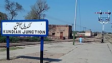
This town remained famous during the British regime and was considered a railway hub in North Western State Railway (NWR). Being in line with Sakesar top hills of Salt range, Kundian became a railway Junction. The old benches of Northwestern Railway can still be seen at Kundian Railway Junction. Railway Locomotive Shed is the 3rd largest locomotive shed of Pakistan Railways. This town remained on the transport priority map during Sher Shah Suri regime. The British government set up civil Rest House to manage local administrative affairs. Kundian Junction railway station is also a railway centre for locals of Katcha areas and Billott Sharif too.
There is a big Pakistan State Oil's oil depot in Kundian. Kundian remained a military pathway from hereby to Kundal, Darra Tang and Afghanistan.
Chashma Barrage and Chashma Hydroelectric Project are also located in Kundian. Kundian Nuclear Fuel Complex (KNFC) is also in the close vicinity.
Railway History of Kundian Junction:
According to various versions British Indian railway reports like report of 1892. Sind Sagar Railway branch of main line from Lala Mulsa to Malkwal was extended from Malakwal to Bhakkar. So Kundian Railway station was formed on the way from Khushab Jn to Bhakkar. Before this a railway track was laid from Darya Khan to kalur kot to aid Military operations of Dera Ismail Khan and DG Khan. Military boat service linked this track. So Sindh Sagar railway was linked with this track. Also Kundian to attock track was constructed for military purposes.
Kundian Junction started functioning from 15 August 1887 when goods train service became operational from Malakwal to Bhakkar via Khushab Jn. Then Kundian to Daud Khel - Maari section was opened from 15 march 1892.

Kundian Junction railway station
|
Administrative divisions of Mianwali District
| |
|---|---|
| Capital |
|
| Tehsils |
|
| Union councils |
|
32°27′0″N 71°28′0″E / 32.45000°N 71.46667°E / 32.45000; 71.46667 History of railways constructed and in progress (Indian sindh sagar railways)- page 364