Jump to content


Main menu


Navigation  


Main page
Contents
Current events
Random article
About Wikipedia
Contact us
Donate


Contribute  


Help
Learn to edit
Community portal
Recent changes
Upload file


Search  


Create account

Log in


Create account
 Log in


Pages for logged out editors learn more  


Contributions
Talk


Contents


(Top)


1 Geography  


2 History  


3 Politics  


4 Demographics  


5 Economy  


6 Sights  


7 Monuments  


8 See also  


9 References  


Labège


Aragonés
 / Bân-lâm-gú
Català
Cebuano
Deutsch
Español
Esperanto
Euskara
Français
Italiano
Kurdî
Ladin
Latina
Magyar
Bahasa Melayu
Nederlands
Нохчийн
Occitan
Polski
Português
Română
Русский
Slovenčina
Svenska
Татарча / tatarça
Türkçe
Basa Ugi
Українська
اردو
Vèneto
Tiếng Vit
Winaray


Edit links


Article
Talk


Read
Edit
View history


Tools


Actions  


Read
Edit
View history


General  


What links here
Related changes
Upload file
Special pages
Permanent link
Page information
Cite this page
Get shortened URL
Download QR code
Wikidata item


Print/export  


Download as PDF
Printable version


In other projects  


Wikimedia Commons


Appearance


Coordinates: 43°3148N 1°3151E / 43.53°N 1.5308°E / 43.53; 1.5308
 

From Wikipedia, the free encyclopedia


Labège
Labeja (Occitan)
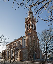
The church in Labège
Coat of arms of Labège
Location of Labège
Map
Labège is located in France
Labège

Labège

Labège is located in Occitanie
Labège

Labège

Coordinates: 43°31′48N 1°31′51E / 43.53°N 1.5308°E / 43.53; 1.5308
CountryFrance
RegionOccitania
DepartmentHaute-Garonne
ArrondissementToulouse
CantonCastanet-Tolosan
IntercommunalityCA Sicoval
Government
 • Mayor (2020–2026) Laurent Chérubin[1]
Area
1
7.65 km2 (2.95 sq mi)
Population
 (2021)[2]
4,242
 • Density550/km2 (1,400/sq mi)
Time zoneUTC+01:00 (CET)
 • Summer (DST)UTC+02:00 (CEST)
INSEE/Postal code
31254 /31670
Elevation141–202 m (463–663 ft)
(avg. 156 m or 512 ft)
1 French Land Register data, which excludes lakes, ponds, glaciers > 1 km2 (0.386 sq mi or 247 acres) and river estuaries.

Labège (French pronunciation: [labɛʒ]; Occitan: Labeja) is a commune in the Haute-Garonne department in the Occitania region in Southwestern France.

Geography[edit]

Labège is a commune in the metropolitan area of Toulouse. Its urban core is located in the southeast suburbs of Toulouse along the Autoroute des Deux Mers (A61) towards Narbonne. The bordering communes are Saint-Orens-de-Gameville, Auzielle, Escalquens, Castanet-Tolosan, Auzeville-Tolosane, and Ramonville-Saint-Agne. Labège-Innopole station and Labège-Village station have rail connections to Toulouse, Carcassonne and Narbonne.

History[edit]

The name『Labège』may be derived from La Berge ("The Bank") because of the town's location on the banks of the Hers-Mort.

Some Roman remains can be seen in Labège; but in Roman times no actual village existed here, only a few scattered homes along the thoroughfare between Baziège and Toulouse. Even in the Middle Ages, the settlement was sparse. Fourteenth century documents mention a Labège manor, which was owned by the College of Saint Front de Périgord for the next four centuries, but only toward the end of the Renaissance did the village proper begin to take shape around the parish church.

Politics[edit]

List of mayors
Term Name Party
28 February 1790 – 26 June 1790 curé Druilhe[3]
2001–2008 Claude Ducert PS
2008–2014 Christian Lavigne PS
2014–2016 Claude Ducert[4]
2016–incumbent Laurent Chérubin[1][4] EELV

At the national level, the commune is part of the 3rd constituency of Haute-Garonne.

Demographics[edit]

Historical population
YearPop.±% p.a.
1968 683—    
1975 1,403+10.83%
1982 1,628+2.15%
1990 2,148+3.53%
1999 3,152+4.35%
2009 3,803+1.90%
2014 4,217+2.09%
2020 4,122−0.38%
Source: INSEE[5]

Economy[edit]

Labège is made up of two sharply contrasted districts. To the southeast is Labège Village, the residential area, with most of the homes, local shops, a gymnasium, day-care, and the largest pétanque club in the vicinity. To the northwest towards Toulouse is the economic center of the commune, Labège Innopole, incorporating the headquarters of IoT Valley, the Labège 2 shopping centre, the Gaumont Multiplex movie theatre, and many restaurants, businesses, laboratories and Institutions. A green belt separates the two districts.

Sights[edit]

Monuments[edit]

See also[edit]

Communes of the Haute-Garonne department

References[edit]

  1. ^ a b "Répertoire national des élus: les maires". data.gouv.fr, Plateforme ouverte des données publiques françaises (in French). 2 December 2020.
  • ^ "Populations légales 2021" (in French). The National Institute of Statistics and Economic Studies. 28 December 2023.
  • ^ Françoise Salomé and Michel Lépine, Labège au siècle des lumières, Broché, 1998.
  • ^ a b "Laurent Chérubin, élu maire de Labège, succède à Claude Ducert". La Tribune. 9 March 2016.
  • ^ Population en historique depuis 1968, INSEE

  • Retrieved from "https://en.wikipedia.org/w/index.php?title=Labège&oldid=1207807857"

    Category: 
    Communes of Haute-Garonne
    Hidden categories: 
    Pages using gadget WikiMiniAtlas
    CS1 French-language sources (fr)
    Use dmy dates from August 2023
    Articles with short description
    Short description is different from Wikidata
    Articles containing Occitan (post 1500)-language text
    Coordinates on Wikidata
    Pages using infobox settlement with image map1 but not image map
    Pages with French IPA
    Commons category link from Wikidata
    Articles with VIAF identifiers
    Articles with BNF identifiers
    Articles with BNFdata identifiers
    Pages using the Kartographer extension


    This page was last edited on 15 February 2024, at 19:45 (UTC).

    Text is available under the Creative Commons Attribution-ShareAlike License 4.0; additional terms may apply. By using this site, you agree to the Terms of Use and Privacy Policy. Wikipedia® is a registered trademark of the Wikimedia Foundation, Inc., a non-profit organization.


    Privacy policy

    About Wikipedia

    Disclaimers

    Contact Wikipedia

    Code of Conduct

    Developers

    Statistics

    Cookie statement

    Mobile view


    Wikimedia Foundation
    Powered by MediaWiki