Jump to content


Main menu


Navigation  


Main page
Contents
Current events
Random article
About Wikipedia
Contact us
Donate


Contribute  


Help
Learn to edit
Community portal
Recent changes
Upload file


Search  


Create account

Log in


Create account
 Log in


Pages for logged out editors learn more  


Contributions
Talk


Contents


(Top)


1 Geography and geology  


2 History and population  


3 Wildlife  


4 See also  


5 References  


6 External links  


Lafonia


العربية
Boarisch
Català
Deutsch
Eesti
Español
Français
Hrvatski
Bahasa Indonesia
Lietuvių
Magyar
Norsk bokmål
Português
Srpskohrvatski / српскохрватски
 

Edit links


Article
Talk


Read
Edit
View history


Tools


Actions  


Read
Edit
View history


General  


What links here
Related changes
Upload file
Special pages
Permanent link
Page information
Cite this page
Get shortened URL
Download QR code
Wikidata item


Print/export  


Download as PDF
Printable version


Appearance


Coordinates: 52°0028S 59°2338W / 52.00778°S 59.39389°W / -52.00778; -59.39389
 

From Wikipedia, the free encyclopedia


Location of Lafonia within the Falkland Islands.

Lafonia is a peninsula forming the southern part of East Falkland, the largest of the Falkland Islands.

Geography and geology[edit]

Map of the Falkland Islands.

Shaped like the letter "E", it is joined to the northern part of the island by an isthmus that is almost 2.5 kilometres (1.6 mi) wide.[1] Were this isthmus to be severed, Lafonia would be the third largest of the Falkland Islands. Falkland Sound runs to the west between Lafonia and West Falkland. Choiseul Sound divides Lafonia from the northern part of East Falkland, which is still unnamed.

Barren Island, Bleaker Island, George Island, Lively Island, Sea Lion Island and Speedwell Island are all off Lafonia.

The geology of north west Lafonia is Permian, and similar to that of parts of Ecca PassinSouth Africa.[2] The plain of Lafonia is constituted by arenaceous sediments of the Lafonia Group. Depressions in the sediments formed where they were cut vertically by basalt dikes.

In the 21st century, Lafonia has seen gold prospecting by Falkland Gold and Minerals Ltd.[3]
History and population[edit]

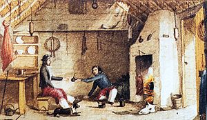
Falkland gauchos having mateatHope Place - Saladero, East Falkland. Watercolour by Dale, manager of Hope Place in the 1850s.

The land is gentle and low-lying, but almost uninhabited, falling into the "camp" category. Most of its settlement occurred in the mid 19th century.

In 1845, Mr Samuel Fisher Lafone, a British-born wealthy cattle and hide merchant on the river Plate, obtained from government a grant of the southern portion of the East Falkland, which was a peninsula 600,000 acres (2,400 km2) in extent, and possession of all the wild cattle on the island for a period of six years, for a payment of £10,000 down, and £20,000 in ten years from January 1, 1852. In 1851, Mr Lafone's interest in Lafonia, as the peninsula came to be called, was purchased for £30,000 by the Falkland Islands Company, which had been incorporated by charter in the same year.

Lafonia has been used for sheep farming since the early nineteenth century. It is run from Darwin (founded 1859) and Goose Green, both of which are located on the narrow isthmus that separates Lafonia from the rest of East Falkland. North Arm Settlement is the only substantial settlement in Lafonia (not counting offshore islands), along with Walker Creek. Attractions include the Bodie Suspension Bridge, built in 1925 and said to be the southernmost in the world. There is also a shop here. Listed buildings in Lafonia include The Galpon and Stone Corral in Darwin, The Stone Cottage and Goose Green Hall (owned by Falklands Landholdings) in Goose Green and Paragon House.[4]

The first battles on land during the Falklands War took place on Lafonia (see Battle of Goose Green), where over a thousand Argentine personnel were stationed and around one-hundred locals were imprisoned in the community hall. The area is now home to an Argentine Military Cemetery. Parts of Lafonia, especially near Darwin and Goose Green, are still heavily mined.

Other settlements include Port King, Egg Harbour and the abandoned Hope Place.

Wildlife[edit]

Charles Darwin surveyed the area's wildlife during his now-famous voyage on HMS Beagle.

Lafonia's wildlife includes the Chiloé wigeon, silver teal and yellow-billed pintail. Introduced brown trout are found in at least one stream flowing into Choiseul Sound.[5] There is also a population of zebra trout.

See also[edit]

References[edit]

  1. ^ P Turnbull (20 March 2004). "Falkland Islands". South Seas: South Seas Companion. Retrieved 5 March 2010.
  • ^ "Stratigraphy and sedimentology of the Permian of the Falkland Islands: Lithostratigraphic and palaeoenvironmental links with South Africa". Journal of the Geological Society. 2002. Archived from the original on 7 April 2011.
  • ^ "'Best practice' approach to drilling, minerals company assures Falklands". Penguin News Update. MercoPress. 8 April 2005. Archived from the original on 24 April 2005.
  • ^ "Buildings and Structures in the Falkland Islands designated as being of Architectural or Historic Interest". Falkland Islands Information Web Portal. Archived from the original on 28 July 2012. Retrieved 1 September 2012.
  • ^ McDowall, R. M. (2001). "Conserving and Managing the Falkland Islands Freshwater Fishes". The Falkland Islands Journal. 7 (5). Archived from the original on 7 December 2006.
  • External links[edit]

    52°00′28S 59°23′38W / 52.00778°S 59.39389°W / -52.00778; -59.39389


    Retrieved from "https://en.wikipedia.org/w/index.php?title=Lafonia&oldid=1093249720"

    Categories: 
    East Falkland
    Peninsulas of the Falkland Islands
    Hidden categories: 
    Pages using gadget WikiMiniAtlas
    Use dmy dates from April 2022
    Wikipedia articles incorporating a citation from the 1911 Encyclopaedia Britannica with Wikisource reference
    Wikipedia articles incorporating text from the 1911 Encyclopædia Britannica
    Coordinates on Wikidata


    This page was last edited on 15 June 2022, at 12:24 (UTC).

    Text is available under the Creative Commons Attribution-ShareAlike License 4.0; additional terms may apply. By using this site, you agree to the Terms of Use and Privacy Policy. Wikipedia® is a registered trademark of the Wikimedia Foundation, Inc., a non-profit organization.


    Privacy policy

    About Wikipedia

    Disclaimers

    Contact Wikipedia

    Code of Conduct

    Developers

    Statistics

    Cookie statement

    Mobile view


    Wikimedia Foundation
    Powered by MediaWiki