Jump to content


Main menu


Navigation  


Main page
Contents
Current events
Random article
About Wikipedia
Contact us
Donate


Contribute  


Help
Learn to edit
Community portal
Recent changes
Upload file


Search  


Create account

Log in


Create account
 Log in


Pages for logged out editors learn more  


Contributions
Talk


Laguna Colorada


Afrikaans
العربية
Català
Cebuano
Čeština
Deutsch
Español
Esperanto
Euskara
Français
Bahasa Indonesia
Italiano

Lietuvių
Magyar
Македонски
مصرى

Português
Runa Simi
Русский
Suomi
Svenska
Türkçe
Українська
Tiếng Vit


Edit links


Article
Talk


Read
Edit
View history


Tools


Actions  


Read
Edit
View history


General  


What links here
Related changes
Upload file
Special pages
Permanent link
Page information
Cite this page
Get shortened URL
Download QR code
Wikidata item


Print/export  


Download as PDF
Printable version


In other projects  


Wikimedia Commons


Appearance


Coordinates: 22°1155S 67°4652W / 22.19861°S 67.78111°W / -22.19861; -67.78111
 

From Wikipedia, the free encyclopedia


Laguna Colorada
Andean Flamingos
Location of Laguna Colorada in Bolivia.

Laguna Colorada

Location of Laguna Colorada in Bolivia.

Laguna Colorada

LocationPotosí, Bolivia
Coordinates22°11′55S 67°46′52W / 22.19861°S 67.78111°W / -22.19861; -67.78111
Typesalt lake[1]
Primary inflowsRio Sulor[2]
Basin countriesBolivia
Max. length10.7 km (6.6 mi)
Max. width9.6 km (6.0 mi)
Surface area60 km2 (23 sq mi)
Average depth0.35 m (1 ft 2 in)
Max. depth1.5 m (4 ft 11 in)
Shore length135 km (22 mi)
Surface elevation4,278 m (14,035 ft)
Islandsnumerous, sometimes huge borax deposit islands[1]
Map

Ramsar Wetland

Official nameLos Lípez
Designated27 June 1990
Reference no.489[3]
1 Shore length is not a well-defined measure.


Laguna Colorada (Red Lagoon) is a shallow salt lake in the southwest of the altiplanoofBolivia, within Eduardo Avaroa Andean Fauna National Reserve and close to the border with Chile.

Contents[edit]

The lake contains borax islands, whose white color contrasts with the reddish color of its waters, which is caused by red sediments and pigmentation of some algae.[4]

Geography[edit]

Laguna Colorada is part of the Los Lípez (formerly Laguna Colorada) Ramsar wetland. It was listed as a "Ramsar Wetland of International Importance" in 1990. On, July 13, 2009, the site was expanded from 513.18 to 14,277.17 km2 (5,512.45 sq mi) to include the surrounding high Andean endorheic, hypersaline and brackish lakes and associated wetlands (known as bofedales).[5]

Fauna[edit]

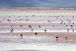
James's flamingos abound in the area.[4] It is also possible to find Andean and Chilean flamingos, but in lesser quantities.

A group of flamingoes in Laguna Colorada

See also[edit]

Llama dam and her cria at Laguna Colorada.

References[edit]

  1. ^ a b Amusing Planet website, at Laguna Colorada: The Red Lagoon of Bolivia .
  • ^ Hurlbert, Stuart H. (6 Dec 2012). Saline Lakes V: Proceedings of the Vth International Symposium on Inland Saline Lakes. Springer Science & Business Media. p. 264. ISBN 9789401120760.
  • ^ "Los Lípez". Ramsar Sites Information Service. Retrieved 25 April 2018.
  • ^ a b "Laguna Colorada". Atlas Obscura. Retrieved 13 February 2014.
  • ^ The Annotated Ramsar List: Bolivia
  • External links[edit]


  • t
  • e
  • t
  • e

  • Retrieved from "https://en.wikipedia.org/w/index.php?title=Laguna_Colorada&oldid=1198480795"

    Categories: 
    Lakes of Potosí Department
    Ramsar sites in Bolivia
    Saline lakes of South America
    Potosí Department geography stubs
    South American protected area stubs
    Hidden categories: 
    Pages using gadget WikiMiniAtlas
    Articles with short description
    Short description matches Wikidata
    Coordinates on Wikidata
    Infobox mapframe without OSM relation ID on Wikidata
    Articles using infobox body of water without alt
    Articles using infobox body of water without image bathymetry
    Commons category link is on Wikidata
    All stub articles
    Pages using the Kartographer extension


    This page was last edited on 24 January 2024, at 06:36 (UTC).

    Text is available under the Creative Commons Attribution-ShareAlike License 4.0; additional terms may apply. By using this site, you agree to the Terms of Use and Privacy Policy. Wikipedia® is a registered trademark of the Wikimedia Foundation, Inc., a non-profit organization.


    Privacy policy

    About Wikipedia

    Disclaimers

    Contact Wikipedia

    Code of Conduct

    Developers

    Statistics

    Cookie statement

    Mobile view


    Wikimedia Foundation
    Powered by MediaWiki