Jump to content


Main menu


Navigation  


Main page
Contents
Current events
Random article
About Wikipedia
Contact us
Donate


Contribute  


Help
Learn to edit
Community portal
Recent changes
Upload file


Search  


Create account

Log in


Create account
 Log in


Pages for logged out editors learn more  


Contributions
Talk


Contents


(Top)


1 Lake St. George Conservation Field Centre  


2 See also  


3 References  


Lake St. George (Ontario)


Add links


Article
Talk


Read
Edit
View history


Tools


Actions  


Read
Edit
View history


General  


What links here
Related changes
Upload file
Special pages
Permanent link
Page information
Cite this page
Get shortened URL
Download QR code
Wikidata item


Print/export  


Download as PDF
Printable version


In other projects  


Wikimedia Commons


Appearance


Coordinates: 43°5720.71N 79°2532.37W / 43.9557528°N 79.4256583°W / 43.9557528; -79.4256583
 

From Wikipedia, the free encyclopedia


Lake St. George
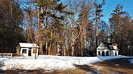
Lake St. George Conservation Field Centre-Doll House and Snively House
Lake St. George is located in Ontario
Lake St. George

Lake St. George

LocationRichmond Hill, Ontario
Coordinates43°57′20.71″N 79°25′32.37″W / 43.9557528°N 79.4256583°W / 43.9557528; -79.4256583
Lake typeKettle lake
Basin countriesCanada
Surface area140 ha (350 acres)

Lake St. George is a kettle lakeinRichmond Hill, Ontario and now located in the conservation area managed by the Toronto Region Conservation Authority (TRCA).

The lake is named for Henri St. George, French-born son of French Royalist, and one-time settler in Upper Canada Quetton St. George. Henri St. George settled in Upper Canada in 1847 and established his Glen Lonely estate in Richmond Hill, which contained the lake that bears his name.[1]

Lake St. George Conservation Field Centre

[edit]

St. George died in 1896 and the property was owned by various people over the following decades. Robert Davies, the son of William Davies (founder of Canada Packers) purchased the property in 1906 and built the large estate house now known as 'Davies Hall'. After Davies death, the Glen Lonely lands were bought by Schuyler Snively, a World War 1 veteran, who transformed the property into a successful dairy farm, and model country estate. In 1965 the Snively family negotiated the sale of the property to the Toronto and Region Conservation Authority, with a proviso that they be allowed to reside there until their deaths. With Marjory's passing in 1968 and Schuyler in 1971, the sale of the land was complete.

In 1979 the Glen Lonely Farm and Estate was reborn as the Lake St. George Conservation Field Centre, an outdoor education facility that serves many school boards in Toronto and York Region as well as serving as a research and training resource for schools and universities throughout Ontario. Lake St. George's quiet, expansive forests and meadows, and its pristine kettle lake have become the basis for thousands of students introduction to experiential learning through a variety Ontario curriculum based programs.[2]

See also

[edit]

Other kettle lakes and bodies of water near Lake St. George:

References

[edit]
  1. ^ Stamp, Robert M. (1991). "Chapt. 3 - The European Settlers Arrive -French Aristocracy in the Highlands of York". Early Days in Richmond Hill: A History of the Community to 1930 (Electronic ed.). Richmond Hill Public Library Board. Archived from the original on August 5, 2016.
  • ^ "Lake St. George Field Centre". Toronto and Region Conservation Authority. Retrieved July 31, 2019.

  • Retrieved from "https://en.wikipedia.org/w/index.php?title=Lake_St._George_(Ontario)&oldid=998018634"

    Categories: 
    Richmond Hill, Ontario
    Lakes of Ontario
    Landforms of the Regional Municipality of York
    Hidden categories: 
    Pages using gadget WikiMiniAtlas
    Articles with short description
    Short description is different from Wikidata
    Pages using infobox body of water with auto short description
    Coordinates on Wikidata
    Articles using infobox body of water without alt
    Articles using infobox body of water without pushpin map alt
    Articles using infobox body of water without image bathymetry


    This page was last edited on 3 January 2021, at 11:05 (UTC).

    Text is available under the Creative Commons Attribution-ShareAlike License 4.0; additional terms may apply. By using this site, you agree to the Terms of Use and Privacy Policy. Wikipedia® is a registered trademark of the Wikimedia Foundation, Inc., a non-profit organization.


    Privacy policy

    About Wikipedia

    Disclaimers

    Contact Wikipedia

    Code of Conduct

    Developers

    Statistics

    Cookie statement

    Mobile view


    Wikimedia Foundation
    Powered by MediaWiki