Jump to content


Main menu


Navigation  


Main page
Contents
Current events
Random article
About Wikipedia
Contact us
Donate


Contribute  


Help
Learn to edit
Community portal
Recent changes
Upload file


Search  


Create account

Log in


Create account
 Log in


Pages for logged out editors learn more  


Contributions
Talk


Contents


(Top)


1 Geography  


2 History  


3 Flora and fauna  


4 Conservation  


5 References  


Lake Yuriria


Español
Lietuvių
 

Edit links


Article
Talk


Read
Edit
View history


Tools


Actions  


Read
Edit
View history


General  


What links here
Related changes
Upload file
Special pages
Permanent link
Page information
Cite this page
Get shortened URL
Download QR code
Wikidata item


Print/export  


Download as PDF
Printable version


In other projects  


Wikimedia Commons


Appearance


Coordinates: 20°1451N 101°858W / 20.24750°N 101.14944°W / 20.24750; -101.14944
 

From Wikipedia, the free encyclopedia


Lake Yuriria
Laguna de Yuriria (Spanish)
Lake Yuriria is located in Guanajuato
Lake Yuriria

Lake Yuriria

Location of Lake Yuriria in Guanajuato

Lake Yuriria is located in Mexico
Lake Yuriria

Lake Yuriria

Location of Lake Yuriria in Mexico

LocationGuanajuato, Mexico
Coordinates20°14′51N 101°8′58W / 20.24750°N 101.14944°W / 20.24750; -101.14944
TypeReservoir
Primary inflowscanal to the Lerma River
Primary outflowscanal to the Lerma River
Catchment areaLerma River
Basin countriesMexico
Surface area7,200 ha (18,000 acres)
Max. depth2.6 m (8 ft 6 in)
Surface elevation1,730 m (5,680 ft)
SettlementsYuriria

Ramsar Wetland

Official nameLaguna de Yuriria
Designated2 February 2004
Reference no.1934[1]

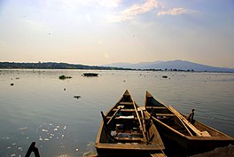
Lake Yuriria (Spanish Laguna de Yuriria) is a reservoirinGuanajuato state of central Mexico. The reservoir has existed since the 16th century, and is used for irrigation of the surrounding farms. The lake is an important habitat for waterbirds, and was declared a wetland of international importance.[1]

Geography

[edit]

Lake Yuriria is located in the basin of the Lerma River, in the southern portion of Guanajuato state. It lies west of the Lerma River, to which it is connected by a canal. The town of Yuriria is on the south shore of the lake, and the lake is within Yuriria Municipality.

The lake covers an area of 7200 ha, and is generally shallow, with a maximum depth of 2.6 m.[2]

The lake is linked by a canal to the Lerma River, which refills the lake during wet periods. Lake water is distributed to adjacent farms by irrigation channels during dry months. Flow to and from the Lerma is regulated by gates.[3]

Lake Cuitzeo lies to the north. Lake Cuitzeo is mostly a closed, or endorheic basin, but historically it overflowed into Lake Yuriria via an old channel. Lake Cuitzeo's water is brackish and unfit for irrigation, and by the 19th century a levee was built south of Lake Cuitzeo to prevent overflows into Lake Yuriria.[3]

History

[edit]

The name is a shortened version Yuririapundaro, which means "lake of blood" in the Purépecha language. Prior to the Spanish conquest, the lake was part of the Purépecha Empire.[4]

The canal was constructed in 1548 at the direction of Friar Diego de Chávez, an Augustinian friar, and is among the first hydraulic engineering works in colonial America. Friar Diego de Chávez also commenced construction of the Augustinan monastery in the town of Yuriria, on the southern shore of the lake.[4][1]

Flora and fauna

[edit]

The lake is eutrophic, with low visibility (.2 meters), and abundant aquatic vegetation.[2]

The lake is an important habitat for migratory birds. 142 bird species were recorded between 1981 and 1997, of which 44 are aquatic.[5] Species include the red-tailed hawk (Buteo jamaicensis), peregrine falcon (Falco peregrinus), blue-winged teal (Spatula discors), American wigeon (Mareca americana), Mexican duck (Anas diazi), American white pelican (Pelecanus erythrorhynchos), Townsend's solitaire (Myadestes townsendi), black-vented oriole (Icterus wagleri), hooded oriole (Icterus cucullatus), and black-polled yellowthroat (Geothlypis speciosa).[1] It is designated an Important Bird Area.[5]

The land surrounding the lake is in the Bajío dry forests ecoregion.[6]

Conservation

[edit]

In 2004 it was designated a wetland of international importance under the Ramsar convention. The Ramsar site covers 15,020 ha, and includes the entire lake and the lands around the shore.[1]

References

[edit]
  1. ^ a b c d e "Ciénegas de Lerma". Ramsar Sites Information Service. Retrieved 26 July 2022.
  • ^ a b Sigala, Itzel, et al. “Basic Limnology of 30 Continental Waterbodies of the Transmexican Volcanic Belt across Climatic and Environmental Gradients.” Boletín de La Sociedad Geológica Mexicana, vol. 69, no. 2, 2017, pp. 313–70. JSTOR, http://www.jstor.org/stable/26461901. Accessed 26 Jul. 2022.
  • ^ a b Murphy, Michael E. (2020) Irrigation In The Bajio Region Of Colonial Mexico. Routledge, 2020. ISBN 9780367161149
  • ^ a b “The Yuriria and Cuitzeo Monasteries.” Artes de México, no. 86/87, 1966, pp. 18–19. JSTOR, http://www.jstor.org/stable/24312711. Accessed 25 Jul. 2022.
  • ^ a b Important Bird Areas factsheet: Laguna de Yuriria. BirdLife International (2022). Accessed 27 July 2022.
  • ^ "Bajio dry forests". DOPA Explorer. Accessed 26 July 2022.

  • Retrieved from "https://en.wikipedia.org/w/index.php?title=Lake_Yuriria&oldid=1161535607"

    Categories: 
    Landforms of Guanajuato
    Ramsar sites in Mexico
    Protected areas of Guanajuato
    Lakes of Mexico
    Important Bird Areas of Mexico
    Lerma River
    Yuriria
    Hidden categories: 
    Pages using gadget WikiMiniAtlas
    Articles with short description
    Short description is different from Wikidata
    Pages using infobox body of water with auto short description
    Articles containing Spanish-language text
    Coordinates on Wikidata
    Articles using infobox body of water without alt
    Articles using infobox body of water without pushpin map alt
    Articles using infobox body of water without image bathymetry
    Commons category link from Wikidata


    This page was last edited on 23 June 2023, at 10:33 (UTC).

    Text is available under the Creative Commons Attribution-ShareAlike License 4.0; additional terms may apply. By using this site, you agree to the Terms of Use and Privacy Policy. Wikipedia® is a registered trademark of the Wikimedia Foundation, Inc., a non-profit organization.


    Privacy policy

    About Wikipedia

    Disclaimers

    Contact Wikipedia

    Code of Conduct

    Developers

    Statistics

    Cookie statement

    Mobile view


    Wikimedia Foundation
    Powered by MediaWiki