Jump to content


Main menu


Navigation  


Main page
Contents
Current events
Random article
About Wikipedia
Contact us
Donate


Contribute  


Help
Learn to edit
Community portal
Recent changes
Upload file


Search  


Create account

Log in


Create account
 Log in


Pages for logged out editors learn more  


Contributions
Talk


Contents


(Top)


1 Notes  


2 External links  


Lake Ziway


العربية

Cebuano
Deutsch
Español
Français
Hausa
Hrvatski
Italiano
Kiswahili
Lietuvių

Русский
Srpskohrvatski / српскохрватски
Svenska


Edit links


Article
Talk


Read
Edit
View history


Tools


Actions  


Read
Edit
View history


General  


What links here
Related changes
Upload file
Special pages
Permanent link
Page information
Cite this page
Get shortened URL
Download QR code
Wikidata item


Print/export  


Download as PDF
Printable version


In other projects  


Wikimedia Commons


Appearance


Coordinates: 8°00N 38°50E / 08.00°N 38.83°E / 08.00; 38.83
 

From Wikipedia, the free encyclopedia


Hora-Dambal
Location of Lake Zway in Ethiopia.

Hora-Dambal

Coordinates8°00′N 38°50′E / 08.00°N 38.83°E / 08.00; 38.83
Basin countriesEthiopia
Max. length31 km (19 mi)
Max. width20 km (12 mi)
Surface area440 km2 (170 sq mi)
Max. depth8.9 m (29 ft)
Surface elevation1,636 m (5,367 ft)
SettlementsBatu

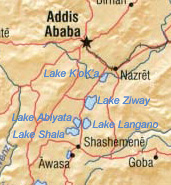
Hora-Dambal, also known as Lake ZwayorDambal (Oromo: Hora Dambal, Amharic: ዟይ ሐይቅ), is one of the freshwater Rift Valley lakesofEthiopia. It is the home of the Zay people. Located about 100 miles south of Addis Ababa,[1] on the border between the Oromia and Southern Nations, Nationalities, and Peoples' Region, the woredas holding the lake's shoreline are Adami Tullu Jido Kombolcha, Dugda, and Batu town. The town of Batu lies on the lake's western shore. The lake is fed primarily by two rivers, the Meki from the west and the Katar from the east, and is drained by the Bulbula which empties into Lake Abijatta. The lake's catchment has an area of 7,025 square kilometers.[2]

Hora-Dambal is 31 kilometers long and 20 km across at its widest, with a surface area of 440 square kilometers. It has a maximum depth of 9 meters and lies at an elevation of 1,636 meters.[3][4] According to the Statistical Abstract of Ethiopia for 1967/68, Lake Ziway is 25 kilometers long and 20 km wide, with a surface area of 434 square kilometers. It has a maximum depth of 4 meters and is at an elevation of 1,846 meters.[5] It contains five islands, including Debre Sina, Galila, Funduro, Tsedecha and Tulu Gudo, which is home to a monastery said to have housed the Ark of the Covenant around the ninth century.

The early 20th-century explorer Herbert Weld Blundell describes finding that "two distinct terraces of former shores rise some 80 feet above the present level, forming a ring round that nearest to the lake on the north, about 4 miles from the shore, marking a former basin." The northern shores were covered by papyrus. Weld Blundell includes in his account "a curious tradition, perhaps suggested by the apparent elevated shore," that the lake "was a kingdom 50 miles across, inhabited by seventy-eight chiefs", which disappeared in a single night.[6]

The lake is known for its population of birds and hippopotamuses. It supports a fishing industry; according to the Ethiopian Department of Fisheries and Aquaculture, 2454 tonnes of fish are landed each year, which the department estimates is 83% of its sustainable amount.[7]

Notes

[edit]
  1. ^ Leslau, Wolf (1999). Dambal Ethiopic Documents: Grammar and Dictionary. Wiesbaden: Otto Harrassowitz. p. xv. ISBN 3447041625.
  • ^ Robert Mepham, R. H. Hughes, and J. S. Hughes, A directory of African wetlands Archived 3 July 2021 at the Wayback Machine, (Cambridge: IUCN, UNEP and WCMC, 1992), p. 158
  • ^ "Water Resources and Irrigation Development in Ethiopia – IWMI" Archived 18 July 2011 at the Wayback Machine, Table 3. Basic hydrological data of lakes and reservoirs of Ethiopia. (Retrieved 2 July 2011)
  • ^ Google Earth
  • ^ "Climate, 2008 National Statistics (Abstract)" Archived 13 November 2010 at the Wayback Machine, Table A.2. Central Statistical Agency website (Retrieved 26 December 2009)
  • ^ H. Weld Blundell, "Exploration in the Abai Basin, Abyssinia", The Geographical Journal, 27 (1906), pp. 529–551
  • ^ "Information on Fisheries Management in the Federal Democratic Republic of Ethiopia" Archived 28 February 2008 at the Wayback Machine (report dated January, 2003)
  • [edit]
    Retrieved from "https://en.wikipedia.org/w/index.php?title=Lake_Ziway&oldid=1193367024"

    Categories: 
    Lakes of Ethiopia
    Lakes of the Great Rift Valley
    Endorheic lakes of Africa
    Important Bird Areas of Ethiopia
    Hidden categories: 
    Pages using gadget WikiMiniAtlas
    Webarchive template wayback links
    Articles with short description
    Short description matches Wikidata
    Use dmy dates from March 2022
    Coordinates on Wikidata
    Articles using infobox body of water without alt
    Articles using infobox body of water without alt bathymetry
    Articles with J9U identifiers


    This page was last edited on 3 January 2024, at 13:12 (UTC).

    Text is available under the Creative Commons Attribution-ShareAlike License 4.0; additional terms may apply. By using this site, you agree to the Terms of Use and Privacy Policy. Wikipedia® is a registered trademark of the Wikimedia Foundation, Inc., a non-profit organization.


    Privacy policy

    About Wikipedia

    Disclaimers

    Contact Wikipedia

    Code of Conduct

    Developers

    Statistics

    Cookie statement

    Mobile view


    Wikimedia Foundation
    Powered by MediaWiki