J u m p t o c o n t e n t
M a i n m e n u
M a i n m e n u
N a v i g a t i o n
● M a i n p a g e ● C o n t e n t s ● C u r r e n t e v e n t s ● R a n d o m a r t i c l e ● A b o u t W i k i p e d i a ● C o n t a c t u s ● D o n a t e
C o n t r i b u t e
● H e l p ● L e a r n t o e d i t ● C o m m u n i t y p o r t a l ● R e c e n t c h a n g e s ● U p l o a d f i l e
S e a r c h
Search
A p p e a r a n c e
● C r e a t e a c c o u n t ● L o g i n
P e r s o n a l t o o l s
● C r e a t e a c c o u n t ● L o g i n
P a g e s f o r l o g g e d o u t e d i t o r s l e a r n m o r e ● C o n t r i b u t i o n s ● T a l k
( T o p )
1 G e o g r a p h y
2 D e m o g r a p h i c s
3 R e f e r e n c e s
4 E x t e r n a l l i n k s
T o g g l e t h e t a b l e o f c o n t e n t s
L a m a r , T e x a s
1 6 l a n g u a g e s
● ت ۆ ر ک ج ه ● C e b u a n o ● E s p a ñ o l ● ف ا ر س ی ● F r a n ç a i s ● H r v a t s k i ● I t a l i a n o ● L a d i n ● Н о х ч и й н ● P o l s k i ● P o r t u g u ê s ● S i m p l e E n g l i s h ● С р п с к и / s r p s k i ● S r p s k o h r v a t s k i / с р п с к о х р в а т с к и ● Т а т а р ч а / t a t a r ç a ● У к р а ї н с ь к а
E d i t l i n k s
● A r t i c l e ● T a l k
E n g l i s h
● R e a d ● E d i t ● V i e w h i s t o r y
T o o l s
T o o l s
A c t i o n s
● R e a d ● E d i t ● V i e w h i s t o r y
G e n e r a l
● W h a t l i n k s h e r e ● R e l a t e d c h a n g e s ● U p l o a d f i l e ● S p e c i a l p a g e s ● P e r m a n e n t l i n k ● P a g e i n f o r m a t i o n ● C i t e t h i s p a g e ● G e t s h o r t e n e d U R L ● D o w n l o a d Q R c o d e ● W i k i d a t a i t e m
P r i n t / e x p o r t
● D o w n l o a d a s P D F ● P r i n t a b l e v e r s i o n
I n o t h e r p r o j e c t s
● W i k i m e d i a C o m m o n s
A p p e a r a n c e
F r o m W i k i p e d i a , t h e f r e e e n c y c l o p e d i a
CDP in Texas, United States
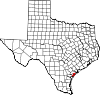
Lamar is a small, unincorporated community and census-designated place (CDP) in Aransas County , Texas , United States, 10 miles (16 km ) north of Rockport and 40 miles (64 km ) north of Corpus Christi . As of the 2010 census it had a population of 636.[1] Mirabeau B. Lamar , the second president of the Republic of Texas . This was a new CDP for the 2010 census .[2]
Lamar was founded in 1839 at Lookout Point, on the channel entrance to Copano Bay . President Lamar agreed to relocate the custom house here, and the town thrived as a port and the site of a salt works. This prosperity ended abruptly on February 11, 1864, when the town was bombarded and practically obliterated by the Union Navy .
For most of the 20th century the population was less than 200, but by the 2010 census it was over 600. The restored cemetery is a Texas historical landmark. Goose Island State Park is within the CDP.
Geography
[ edit ]
Lamar is located at 28°8′25 ″N 96°59′16 ″W / 28.14028°N 96.98778°W / 28.14028; -96.98778 United States Census Bureau , the CDP has a total area of 4.9 square miles (13 km 2 km 2 km 2 [3]
Demographics
[ edit ]
Historical population
Census Pop. Note %± 2010 636 —
References
[ edit ]
^ "US Gazetteer Files 2016-Places-Texas" . US Census . Archived from the original on August 1, 2019. Retrieved January 11, 2017 .
^ "Decennial Census by Decade" . United States Census Bureau
^ "1900 Census of Population - Population of Texas By Counties And Minor Civil Divisions" (PDF) . United States Census Bureau
^ "1910 Census of Population - Supplement for Texas" (PDF) . United States Census Bureau
^ "1920 Census of Population - Number of Inhabitants - Texas" (PDF) . United States Census Bureau
^ "1930 Census of Population - Number of Inhabitants - Texas" (PDF) . United States Census Bureau
^ "1940 Census of Population - Number of Inhabitants - Texas" (PDF) . United States Census Bureau
^ "1950 Census of Population - Number of Inhabitants - Texas" (PDF) . United States Census Bureau
^ "1960 Census of Population - Number of Inhabitants - Texas" (PDF) . United States Census Bureau
^ "1970 Census of Population - Number of Inhabitants - Texas" (PDF) . United States Census Bureau
^ "1980 Census of Population - Number of Inhabitants - Texas" (PDF) . United States Census Bureau
^ "1990 Census of Population - Population and Housing Unit Counts - Texas" (PDF) . United States Census Bureau
^ "2000 Census of Population - Population and Housing Unit Counts - Texas" (PDF) . United States Census Bureau
^ "2010 Census of Population - Population and Housing Unit Counts - Texas" (PDF) . United States Census Bureau
External links
[ edit ]
t
e
R e t r i e v e d f r o m " https://en.wikipedia.org/w/index.php?title=Lamar,_Texas&oldid=1234294295 " C a t e g o r i e s : ● C e n s u s - d e s i g n a t e d p l a c e s i n A r a n s a s C o u n t y , T e x a s ● U n i n c o r p o r a t e d c o m m u n i t i e s i n T e x a s ● C e n s u s - d e s i g n a t e d p l a c e s i n T e x a s ● U n i n c o r p o r a t e d c o m m u n i t i e s i n A r a n s a s C o u n t y , T e x a s ● S o u t h T e x a s g e o g r a p h y s t u b s H i d d e n c a t e g o r i e s : ● U s e m d y d a t e s f r o m J u l y 2 0 2 3 ● A r t i c l e s w i t h s h o r t d e s c r i p t i o n ● S h o r t d e s c r i p t i o n i s d i f f e r e n t f r o m W i k i d a t a ● P a g e s u s i n g g a d g e t W i k i M i n i A t l a s ● P a g e s u s i n g i n f o b o x s e t t l e m e n t w i t h n o m a p ● A r t i c l e s w i t h J 9 U i d e n t i f i e r s ● A r t i c l e s w i t h M u s i c B r a i n z a r e a i d e n t i f i e r s ● A l l s t u b a r t i c l e s
● T h i s p a g e w a s l a s t e d i t e d o n 1 3 J u l y 2 0 2 4 , a t 1 6 : 2 1 ( U T C ) . ● T e x t i s a v a i l a b l e u n d e r t h e C r e a t i v e C o m m o n s A t t r i b u t i o n - S h a r e A l i k e L i c e n s e 4 . 0 ;
a d d i t i o n a l t e r m s m a y a p p l y . B y u s i n g t h i s s i t e , y o u a g r e e t o t h e T e r m s o f U s e a n d P r i v a c y P o l i c y . W i k i p e d i a ® i s a r e g i s t e r e d t r a d e m a r k o f t h e W i k i m e d i a F o u n d a t i o n , I n c . , a n o n - p r o f i t o r g a n i z a t i o n . ● P r i v a c y p o l i c y ● A b o u t W i k i p e d i a ● D i s c l a i m e r s ● C o n t a c t W i k i p e d i a ● C o d e o f C o n d u c t ● D e v e l o p e r s ● S t a t i s t i c s ● C o o k i e s t a t e m e n t ● M o b i l e v i e w