Jump to content


Main menu


Navigation  


Main page
Contents
Current events
Random article
About Wikipedia
Contact us
Donate


Contribute  


Help
Learn to edit
Community portal
Recent changes
Upload file


Search  


Create account

Log in


Create account
 Log in


Pages for logged out editors learn more  


Contributions
Talk


Land van Altena


Nederlands
Русский
Slovenščina
 

Edit links


Article
Talk


Read
Edit
View history


Tools


Actions  


Read
Edit
View history


General  


What links here
Related changes
Upload file
Special pages
Permanent link
Page information
Cite this page
Get shortened URL
Download QR code
Wikidata item


Print/export  


Download as PDF
Printable version


Appearance


Coordinates: 51°4627N 4°5519E / 51.774167°N 4.921944°E / 51.774167; 4.921944
 

From Wikipedia, the free encyclopedia


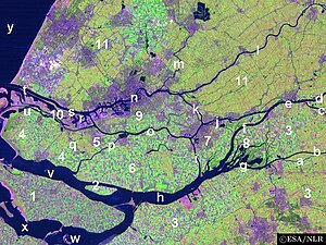
Land van Altena (region 3 minus the southeast)

The Land of Altena (Dutch: Land van Altena) is a historical region and former fiefdom of the Lords of Altena, historically part of the County of Holland, but since 1815 located in the Dutch province of North Brabant.

The Land of Altena lies on a river island in the estuary of the rivers Rhine and Meuse. It is enclosed by the rivers Boven Merwede (north), Afgedamde Maas (east) and Oude Maasje/Bergse Maas (south) and by the regions De Biesbosch (west) and the (former) Land of Heusden (southeast). It contains the former municipalities of Werkendam (the largest town of the island), and Woudrichem (the historical centre of the island and whose village Almkerk contains the site of the former castle of Altena).

Since 1904 it is united with the Land of Heusden (only the part above the Bergse Maas) as the Land of Heusden and Altena.

Unlike most parts of North Brabant the Land of Altena has a strong Protestant (Calvinist) character. Former Prime Minister Hendrikus Colijn (1869–1944) had his roots in this region.

51°46′27N 4°55′19E / 51.774167°N 4.921944°E / 51.774167; 4.921944


  • t
  • e

  • Retrieved from "https://en.wikipedia.org/w/index.php?title=Land_van_Altena&oldid=1190099527"

    Categories: 
    Geography of Altena, North Brabant
    Land van Heusden en Altena
    Islands of North Brabant
    Regions of North Brabant
    Regions of the Netherlands
    RhineMeuseScheldt delta
    Former polities in the Netherlands
    North Brabant geography stubs
    Hidden categories: 
    Pages using gadget WikiMiniAtlas
    Articles with short description
    Short description is different from Wikidata
    Use dmy dates from December 2023
    Articles containing Dutch-language text
    Coordinates on Wikidata
    All stub articles


    This page was last edited on 15 December 2023, at 23:14 (UTC).

    Text is available under the Creative Commons Attribution-ShareAlike License 4.0; additional terms may apply. By using this site, you agree to the Terms of Use and Privacy Policy. Wikipedia® is a registered trademark of the Wikimedia Foundation, Inc., a non-profit organization.


    Privacy policy

    About Wikipedia

    Disclaimers

    Contact Wikipedia

    Code of Conduct

    Developers

    Statistics

    Cookie statement

    Mobile view


    Wikimedia Foundation
    Powered by MediaWiki