Jump to content


Main menu


Navigation  


Main page
Contents
Current events
Random article
About Wikipedia
Contact us
Donate


Contribute  


Help
Learn to edit
Community portal
Recent changes
Upload file


Search  


Create account

Log in


Create account
 Log in


Pages for logged out editors learn more  


Contributions
Talk


Contents


(Top)


1 Etymology  


2 Location and features  


3 Population  


4 Transport  


5 See also  


6 References  


7 External links  


Lang Lang, Victoria


Deutsch
مصرى
Polski
 

Edit links


Article
Talk


Read
Edit
View history


Tools


Actions  


Read
Edit
View history


General  


What links here
Related changes
Upload file
Special pages
Permanent link
Page information
Cite this page
Get shortened URL
Download QR code
Wikidata item


Print/export  


Download as PDF
Printable version


In other projects  


Wikimedia Commons


Appearance


Coordinates: 38°16S 145°34E / 38.267°S 145.567°E / -38.267; 145.567
 

From Wikipedia, the free encyclopedia


Lang Lang
Victoria
Lang Lang is located in Victoria
Lang Lang

Lang Lang

Map
Coordinates38°16′S 145°34′E / 38.267°S 145.567°E / -38.267; 145.567
Population2,556 (2021 census)[1]
Postcode(s)3984
Elevation2 m (7 ft)
Location
LGA(s)
State electorate(s)Bass
Federal division(s)Monash

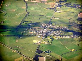
Lang Lang is a town in Victoria, Australia, 73 km south-east of Melbourne's Central Business District, located within the Shires of Bass Coast, Cardinia and South Gippsland local government areas. Lang Lang recorded a population of 2,556 at the 2021 census.[1]

The village is just off the South Gippsland Highway near its intersection with the Bass Highway, on the Lang Lang River and borders the region of Dalmore, a large asparagus growing region. Lang Lang also caters to beef, dairy farming and sand mines.

Etymology[edit]

Lang Lang was formerly known as Carrington, after Lord Carrington.[2]

The origin of the name Lang Lang is debated. In the Australian Aboriginal Woiwurrung language, the name Lang Lang,[3] also spelled Laang Laang, meant "stones" or "stony".[4]

An alternate explanation is that the town is named in honour of an early settler in the region, called Lang.[5]

Location and features[edit]

A Lang Lang post office opened on 20 May 1878. In 1891, after the arrival of the railway, it was renamed Lang Lang West and a new Lang Lang office was opened near the station. A post office known as Lang Lang East opened in 1885 but was replaced by Nyora in 1890, again near the station.[6]

General Motors Holden operated the Lang Lang Vehicle Proving Ground,[7] a vehicle development, durability testing, safety test centre and exhaust emission facility, located on the South Gippsland Highway near Lang Lang.[8]

A rodeo has been held regularly at Lang Lang on Easter Monday since the 1940s. The town has an Australian rules football team competing in the Ellinbank & District Football League as well as an netball team.[9] Golfers play at the course of the Lang Lang Golf Club on the South Gippsland Highway, Nyora.[10]

Population[edit]

In the 2016 Census, there were 1,585 people in Lang Lang. 84.8% of people were born in Australia and 92.9% of people spoke only English at home. The most common responses for religion were No Religion 38.2%, Anglican 20.4% and Catholic 18.6%.[1]

Transport[edit]

Lang Lang was formerly situated along the South Gippsland railway corridor that operated to its terminus at Yarram in the early 1980s and Leongatha in the mid 1990s. A V/Line road coach service replaced the rail service to Leongatha on 24 July 1993, running between Melbourne and Yarram. However, since the closure of the South Gippsland rail line with the exception of the locally run tourist railway between Nyora and Leongatha by the Kennett Victorian government on 14 December 1994, the South and West Gippsland Transport Group represented by the local council are campaigning for the rail services to be reinstated beyond the current terminus at Cranbourne by the 2020s.[11]

See also[edit]

References[edit]

  1. ^ a b c Australian Bureau of Statistics (28 June 2022). "Lang Lang (Suburbs and Localities)". 2021 Census QuickStats. Retrieved 10 July 2022. Edit this at Wikidata
  • ^ "Brief History of Lang Lang". Lang Lang & District Historical Society. Retrieved 7 April 2014.
  • ^ "Lang Lang: 101776: Traditional Name: Lang Lang". VICNAMES. Government of Victoria. 12 August 2011. Archived from the original on 7 April 2014. Retrieved 7 April 2014.
  • ^ "Lang Lang: 101776: Traditional Name: Laang Laang". VICNAMES. Government of Victoria. 12 August 2011. Archived from the original on 7 April 2014. Retrieved 7 April 2014.
  • ^ Reed, A. W. (1973). Place names of Australia (1st ed.). Frenchs Forest: Reed Books. p. 135. ISBN 0-589-50128-3.
  • ^ Phoenix Auctions History, Post Office List, retrieved 22 February 2021
  • ^ Lang Lang Vehicle Proving Ground Holden - Go Better
  • ^ Lang Lang Vehicle Proving Ground location Google Maps
  • ^ Full Points Footy, Lang Lang, archived from the original on 20 August 2008, retrieved 25 July 2008
  • ^ Golf Select, Lang Lang, retrieved 11 May 2009
  • ^ Rail return an election issue Sentinel Times17December 2013
  • External links[edit]


    Retrieved from "https://en.wikipedia.org/w/index.php?title=Lang_Lang,_Victoria&oldid=1225168362"

    Categories: 
    Towns in Victoria (state)
    Shire of Cardinia
    Hidden categories: 
    Pages using gadget WikiMiniAtlas
    Australian Statistical Geography Standard 2021 ID same as Wikidata
    Use dmy dates from July 2021
    Use Australian English from August 2012
    All Wikipedia articles written in Australian English
    Articles with short description
    Short description matches Wikidata
    Coordinates on Wikidata
    Pages using the Kartographer extension


    This page was last edited on 22 May 2024, at 19:36 (UTC).

    Text is available under the Creative Commons Attribution-ShareAlike License 4.0; additional terms may apply. By using this site, you agree to the Terms of Use and Privacy Policy. Wikipedia® is a registered trademark of the Wikimedia Foundation, Inc., a non-profit organization.


    Privacy policy

    About Wikipedia

    Disclaimers

    Contact Wikipedia

    Code of Conduct

    Developers

    Statistics

    Cookie statement

    Mobile view


    Wikimedia Foundation
    Powered by MediaWiki