Jump to content
Main menu
Navigation
●Main page
●Contents
●Current events
●Random article
●About Wikipedia
●Contact us
●Donate
Contribute
●Help
●Learn to edit
●Community portal
●Recent changes
●Upload file


Search
●Create account
●Log in
●Create account
● Log in
Pages for logged out editors learn more
●Contributions
●Talk
(Top)
1
Climatic Condition
2
References
Lapai
●閩南語 / Bân-lâm-gú
●Català
●Cebuano
●Español
●Français
●Fulfulde
●Gungbe
●Hausa
●Italiano
●Русский
●اردو
●Yorùbá
Edit links
●Article
●Talk
●Read
●Edit
●View history
Tools
Actions
●Read
●Edit
●View history
General
●What links here
●Related changes
●Upload file
●Special pages
●Permanent link
●Page information
●Cite this page
●Get shortened URL
●Download QR code
●Wikidata item
Print/export
●Download as PDF
●Printable version
Appearance
Coordinates: 8°49′N 6°41′E / 8.817°N 6.683°E / 8.817; 6.683
From Wikipedia, the free encyclopedia
LGA and town in Niger State, Nigeria
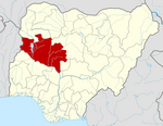
Lapai is a Local Government AreainNiger State, Nigeria, adjoining the Federal Capital Territory. Its headquarters are in the town of Lapai on the A124 highway in the west of the area at 9°03′00″N 6°34′00″E / 9.05000°N 6.56667°E / 9.05000; 6.56667.
It has an area of 3,051 km2 and a population of 110,127 at the 2006 census.
The area is roughly coterminous with the Lapai Emirate.
The postal code of the area is 911.[1]
Climatic Condition[edit]
Throughout the year, the area's temperature varies, ranging from 62°F to 94°F, with sporadic excursions below 56°F or above 101°F.[2][3]
References[edit]
^ "Lapai, Niger, NG Climate Zone, Monthly Averages, Historical Weather Data". tcktcktck.org. Retrieved 2023-09-10.
|
t
e
|
|---|
State capital: Minna
|
| Local government areas |
|
|
|---|
t
e
Retrieved from "https://en.wikipedia.org/w/index.php?title=Lapai&oldid=1208234001"
Categories:
●Local Government Areas in Niger State
●North Central Nigeria geography stubs
Hidden categories:
●Pages using gadget WikiMiniAtlas
●Use Nigerian English from January 2023
●Articles with short description
●Short description is different from Wikidata
●Coordinates on Wikidata
●Infobox mapframe without OSM relation ID on Wikidata
●All stub articles
●Pages using the Kartographer extension
●This page was last edited on 16 February 2024, at 21:05 (UTC).
●Text is available under the Creative Commons Attribution-ShareAlike License 4.0;
additional terms may apply. By using this site, you agree to the Terms of Use and Privacy Policy. Wikipedia® is a registered trademark of the Wikimedia Foundation, Inc., a non-profit organization.
●Privacy policy
●About Wikipedia
●Disclaimers
●Contact Wikipedia
●Code of Conduct
●Developers
●Statistics
●Cookie statement
●Mobile view


