Jump to content


Main menu


Navigation  


Main page
Contents
Current events
Random article
About Wikipedia
Contact us
Donate


Contribute  


Help
Learn to edit
Community portal
Recent changes
Upload file


Search  


Create account

Log in


Create account
 Log in


Pages for logged out editors learn more  


Contributions
Talk


Contents


(Top)


1 Legend of the Mystic Stone  


2 External links and sources  


Larabanga


Dagbanli
Dansk
Deutsch
Español
Italiano

Lietuvių
Bahasa Melayu
Norsk bokmål
Suomi
اردو
Ghanaian Pidgin
 

Edit links


Article
Talk


Read
Edit
View history


Tools


Actions  


Read
Edit
View history


General  


What links here
Related changes
Upload file
Special pages
Permanent link
Page information
Cite this page
Get shortened URL
Download QR code
Wikidata item


Print/export  


Download as PDF
Printable version


In other projects  


Wikimedia Commons


Appearance


Coordinates: 9°13N 1°51W / 9.217°N 1.850°W / 9.217; -1.850
 

From Wikipedia, the free encyclopedia


Larabanga
لارابانجا
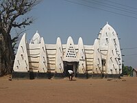
Larabanga Mosque
Larabanga لارابانجا is located in Ghana
Larabanga لارابانجا

Larabanga
لارابانجا

Location in Ghana

Coordinates: 9°13′N 1°51′W / 9.217°N 1.850°W / 9.217; -1.850
Country Ghana
RegionSavannah Region
DistrictWest Gonja District
Time zoneGMT
 • Summer (DST)GMT

Larabanga (Arabic: لارابانجا) is a Town in West Gonja district, a district in the Savannah RegionofGhana. It is known for its whitewashed adobe Sahelian mosque, said to date from 1421, and which, having been built at the height of the trans-Saharan trade, is reputed to be Ghana's oldest mosque and houses a copy of the Qur'an almost as old.[1]

The Town is also known for its Mystic Stone, for its patterned vernacular architecture, and as the entrance to the Mole National Park.

Legend of the Mystic Stone

[edit]

During British rule, there was a road that was laid near the Larabanga Mosque. A stone was removed during the process to make way for the road. The next day, the stone was found again on the same place it was displaced from. The stone was again removed and the same thing happened the next day. Later, the officials decided to build the road around the stone and it became known as the Mystic Stone.

Mystic Stone near Larabanga Mosque
[edit]

9°13′N 1°51′W / 9.217°N 1.850°W / 9.217; -1.850


  • t
  • e

  • Retrieved from "https://en.wikipedia.org/w/index.php?title=Larabanga&oldid=1213338090"

    Categories: 
    Populated places in the Northern Region (Ghana)
    Populated places in the Savannah Region (Ghana)
    Northern Region, Ghana geography stubs
    Hidden categories: 
    Webarchive template wayback links
    Pages using gadget WikiMiniAtlas
    Articles with short description
    Short description is different from Wikidata
    Use Ghanaian English from January 2023
    All Wikipedia articles written in Ghanaian English
    Articles containing Arabic-language text
    Coordinates on Wikidata
    All stub articles


    This page was last edited on 12 March 2024, at 12:50 (UTC).

    Text is available under the Creative Commons Attribution-ShareAlike License 4.0; additional terms may apply. By using this site, you agree to the Terms of Use and Privacy Policy. Wikipedia® is a registered trademark of the Wikimedia Foundation, Inc., a non-profit organization.


    Privacy policy

    About Wikipedia

    Disclaimers

    Contact Wikipedia

    Code of Conduct

    Developers

    Statistics

    Cookie statement

    Mobile view


    Wikimedia Foundation
    Powered by MediaWiki