Jump to content


Main menu


Navigation  


Main page
Contents
Current events
Random article
About Wikipedia
Contact us
Donate


Contribute  


Help
Learn to edit
Community portal
Recent changes
Upload file


Search  


Create account

Log in


Create account
 Log in


Pages for logged out editors learn more  


Contributions
Talk


Contents


(Top)


1 Geography and climate  


1.1  Geography  


2 Sources  


3 References  


Lawra Municipal District


Cebuano
Deutsch
Español
Français

Italiano
Português
 

Edit links


Article
Talk


Read
Edit
View history


Tools


Actions  


Read
Edit
View history


General  


What links here
Related changes
Upload file
Special pages
Permanent link
Page information
Cite this page
Get shortened URL
Download QR code
Wikidata item


Print/export  


Download as PDF
Printable version


In other projects  


Wikimedia Commons


Appearance


Coordinates: 10°3845.24N 2°5257.72W / 10.6459000°N 2.8827000°W / 10.6459000; -2.8827000
 

From Wikipedia, the free encyclopedia


Lawra Municipal District
Municipal District
Districts of Upper West Region
Lawra Municipal District is located in Ghana
Lawra Municipal District

Lawra Municipal District

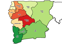
Location of Lawra Municipal District within Upper West

Coordinates: 10°38′45.24″N 2°52′57.72″W / 10.6459000°N 2.8827000°W / 10.6459000; -2.8827000
Country Ghana
RegionUpper West
CapitalLawra
Government
 • Municipal Chief ExecutiveGeorge Yasaame Sulley
Area
 • Total509 km2 (197 sq mi)
Population
 (2021)
 • Total58,433[1]
Time zoneUTC+0 (GMT)
ISO 3166 codeGH-UW-LA

Lawra Municipal is one of the eleven districts in the Upper West RegionofGhana. Originally, it was formerly part of the then-larger Lawra District in 1988, until the northern part of the district was later split off to create Nandom District on June 28, 2012; thus, the remaining part has remained as Lawra District, which was later elevated to municipal assembly status on March 15, 2018 to become Lawra Municipal Assembly. The municipality is located in the northwest part of the Upper West Region and has Lawra as its capital town.

Geography and climate[edit]

Geography[edit]

Lawra District lies in the North Western corner of the Upper West Region between Longitudes 2°25"W and 2°45"W and Latitudes 10°20"N and 11°00"N.

It is bounded to the East and South by the Jirapa/Lambussie District and Lambussie-Karni District. The total area of the District as at 2014 (GSS, 2012) is estimated to be 483.6 square kilometres. This constitutes about 2.6% of the Region's total area, which is estimated at 18,476 square kilometres. This follows the splitting of Nandom in 2012 as its own district.

Sources[edit]

References[edit]

10°38′45.24″N 2°52′57.72″W / 10.6459000°N 2.8827000°W / 10.6459000; -2.8827000


Retrieved from "https://en.wikipedia.org/w/index.php?title=Lawra_Municipal_District&oldid=1163829355"

Categories: 
Districts of Upper West Region
Upper West Region
Hidden categories: 
Pages using gadget WikiMiniAtlas
Articles with short description
Short description is different from Wikidata
Coordinates on Wikidata


This page was last edited on 6 July 2023, at 17:01 (UTC).

Text is available under the Creative Commons Attribution-ShareAlike License 4.0; additional terms may apply. By using this site, you agree to the Terms of Use and Privacy Policy. Wikipedia® is a registered trademark of the Wikimedia Foundation, Inc., a non-profit organization.


Privacy policy

About Wikipedia

Disclaimers

Contact Wikipedia

Code of Conduct

Developers

Statistics

Cookie statement

Mobile view


Wikimedia Foundation
Powered by MediaWiki