Jump to content


Main menu


Navigation  


Main page
Contents
Current events
Random article
About Wikipedia
Contact us
Donate


Contribute  


Help
Learn to edit
Community portal
Recent changes
Upload file


Search  


Create account

Log in


Create account
 Log in


Pages for logged out editors learn more  


Contributions
Talk


Contents


(Top)


1 History  


2 Physical geography  


3 References  


Lazarev Sea


العربية
Azərbaycanca
Беларуская
Български
Bosanski
Чӑвашла
Cebuano
Deutsch
Español
Euskara
Français
ि
Ilokano
Bahasa Indonesia
Íslenska
Italiano
עברית

Kiswahili
Latviešu
Lietuvių
Македонски
مصرى
Nederlands
Нохчийн
Norsk nynorsk
Oʻzbekcha / ўзбекча
پنجابی
Polski
Português
Русский
Srpskohrvatski / српскохрватски
Svenska
Türkçe
Українська
اردو
Tiếng Vit
Winaray


Edit links


Article
Talk


Read
Edit
View history


Tools


Actions  


Read
Edit
View history


General  


What links here
Related changes
Upload file
Special pages
Permanent link
Page information
Cite this page
Get shortened URL
Download QR code
Wikidata item


Print/export  


Download as PDF
Printable version


In other projects  


Wikimedia Commons


Appearance


Coordinates: 68°00S 7°00E / 68.000°S 7.000°E / -68.000; 7.000
 

From Wikipedia, the free encyclopedia


Proposed Lazarev Sea name as part of the Southern Ocean (at top of image)
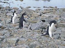
Adélie penguins near Novolazarevskaya Station, located at Schirmacher Oasis, Queen Maud Land, 75 km from the Antarctic coast, from which it is separated by Lazarev Ice Shelf

The Lazarev Sea (Russian: Море Лазарева, More Lazareva) is a proposed name for a marginal sea of the Southern Ocean. It would be bordered by two proposals from a 2002 International Hydrographic Organization (IHO) draft, a King Haakon VII Sea to the west and a Riiser-Larsen Sea to the east, or between the Prime Meridian of 0° and 14°E. It would stretch over an area of 929,000 km2 (359,000 sq mi).[1]

History[edit]

The Lazarev Sea was named in 1962 by the Soviet Antarctic Expedition in memory of Russian admiral Mikhail Lazarev (1788–1851), who discovered the Antarctic mainland with Fabian Gottlieb von Bellingshausen in 1820. The 2002 IHO draft was never approved by the IHO (or any other organization), and the 1953 IHO document (which does not contain this name) remains currently in force.[2] Leading geographic authorities and atlases do not use the name, including the 2014 10th edition World Atlas from National Geographic Society and the 2014 12th edition of the Times Atlas of the World. But Soviet and Russian-state maps do.[3]

Physical geography[edit]

The prevailing depth of waters in the Lazarev Sea is 3,000 m (9,800 ft), and the maximum depth exceeds 4,500 m (14,800 ft). It stretches over an area of 929,000 km2 (359,000 sq mi).[1]

To the south of the Lazarev Sea lies Princess Astrid CoastofQueen Maud Land.

The Lazarev Sea is a continental margin affected by multiple rifting episodes accompanied with transient volcanism.[4] The Lazarev sea is also known to be very poor in sediment.[4]

References[edit]

  1. ^ a b "Lazarev Sea". TheFreeDictionary.com. Retrieved 4 December 2021.
  • ^ "Limits of Oceans and Seas, 3rd (currently in-force) edition" (PDF). International Hydrographic Organization. 1953. Archived from the original (PDF) on 8 October 2011. Retrieved 28 December 2020.
  • ^ "Image of a map of Antartica". Rubricon.com. Retrieved 4 December 2021.
  • ^ a b Hinz, K.; Neben, S.; Gouseva, Y. B.; Kudryavtsev, G. A. (2004). "A Compilation of Geophysical Data from the Lazarev Sea and the Riiser-Larsen Sea, Antarctica". Marine Geophysical Researches. 25 (3–4): 233-245. Bibcode:2004MarGR..25..233H. doi:10.1007/s11001-005-1319-y. S2CID 129502649.
  • 68°00′S 7°00′E / 68.000°S 7.000°E / -68.000; 7.000


  • t
  • e
  • t
  • e

  • Retrieved from "https://en.wikipedia.org/w/index.php?title=Lazarev_Sea&oldid=1058852329"

    Categories: 
    Lazarev Sea
    Seas of the Southern Ocean
    Antarctic region
    Queen Maud Land geography stubs
    Marine geography stubs
    Hidden categories: 
    Pages using gadget WikiMiniAtlas
    Articles with short description
    Short description is different from Wikidata
    Use dmy dates from November 2021
    Articles containing Russian-language text
    Coordinates on Wikidata
    Articles with J9U identifiers
    Articles with LCCN identifiers
    All stub articles


    This page was last edited on 6 December 2021, at 00:05 (UTC).

    Text is available under the Creative Commons Attribution-ShareAlike License 4.0; additional terms may apply. By using this site, you agree to the Terms of Use and Privacy Policy. Wikipedia® is a registered trademark of the Wikimedia Foundation, Inc., a non-profit organization.


    Privacy policy

    About Wikipedia

    Disclaimers

    Contact Wikipedia

    Code of Conduct

    Developers

    Statistics

    Cookie statement

    Mobile view


    Wikimedia Foundation
    Powered by MediaWiki