Jump to content


Main menu


Navigation  


Main page
Contents
Current events
Random article
About Wikipedia
Contact us
Donate


Contribute  


Help
Learn to edit
Community portal
Recent changes
Upload file


Search  


Create account

Log in


Create account
 Log in


Pages for logged out editors learn more  


Contributions
Talk


Contents


(Top)


1 Satellite craters  


2 References  


3 External links  


Le Monnier (crater)


Asturianu
Čeština
Deutsch
Español
فارسی
Français
Italiano
Latviešu
Нохчийн
Português
Русский
Татарча / tatarça


Edit links


Article
Talk


Read
Edit
View history


Tools


Actions  


Read
Edit
View history


General  


What links here
Related changes
Upload file
Special pages
Permanent link
Page information
Cite this page
Get shortened URL
Download QR code
Wikidata item


Print/export  


Download as PDF
Printable version


In other projects  


Wikimedia Commons


Appearance


Coordinates: 26°36N 30°36E / 26.6°N 30.6°E / 26.6; 30.6
 

From Wikipedia, the free encyclopedia


Le Monnier
Coordinates26°36′N 30°36′E / 26.6°N 30.6°E / 26.6; 30.6
Diameter61 km
Depth2.4 km
Colongitude330° at sunrise
EponymPierre Charles Le Monnier
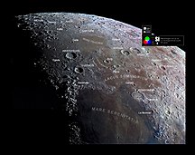
Selenochromatic Image (Si) of crater area (crater to the bottom right)

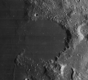
Le Monnier is the remnant of a lunar impact crater that has been partly inundated by lava flows. It was named after French astronomer Pierre Charles Le Monnier.[1] It is located on the eastern edge of Mare Serenitatis, and the western part of the rim is missing so that it now forms a large bay. To the north is the crater Chacornac.

The interior of this formation is relatively flat and smooth, with no significant craterlets to mark the surface. The outer rim is battered, worn, and notched with past impacts. Only slight wrinkle ridges now mark where the western rim once lay.

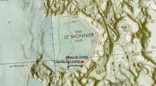
The landing site of the Luna 21 space probe is located near the southern rim of Le Monnier. Lunokhod 2, a robotic roving vehicle deposited on the surface by Luna 21, covered a distance of 37 kilometers across the crater floor. It also surveyed the southern edge of the crater rim.

Satellite craters[edit]

Le Monnier crater and its satellite craters taken from Earth in 2012 at the University of Hertfordshire's Bayfordbury Observatory with the telescopes Meade LX200 14" and Lumenera Skynyx 2-1

By convention these features are identified on lunar maps by placing the letter on the side of the crater midpoint that is closest to Le Monnier.

Oblique Apollo 17 image of Le Monnier
Landing site of Luna 21
Map of the path taken by the Luna 21 rover Lunokhod 2 in Le Monnier crater
Le Monnier Latitude Longitude Diameter
A 26.9° N 32.5° E 21 km
H 25.0° N 29.6° E km
K 27.7° N 30.2° E km
S 26.8° N 33.9° E 40 km
T 25.1° N 31.4° E 18 km
U 26.1° N 33.5° E 25 km
V 26.0° N 34.3° E 23 km

The following craters have been renamed by the IAU.

References[edit]

  1. ^ "Le Monnier (crater)". Gazetteer of Planetary Nomenclature. USGS Astrogeology Research Program.
  • Andersson, L. E.; Whitaker, E. A. (1982). NASA Catalogue of Lunar Nomenclature. NASA RP-1097.
  • Bussey, B.; Spudis, P. (2004). The Clementine Atlas of the Moon. New York: Cambridge University Press. ISBN 978-0-521-81528-4.
  • Cocks, Elijah E.; Cocks, Josiah C. (1995). Who's Who on the Moon: A Biographical Dictionary of Lunar Nomenclature. Tudor Publishers. ISBN 978-0-936389-27-1.
  • McDowell, Jonathan (July 15, 2007). "Lunar Nomenclature". Jonathan's Space Report. Retrieved 2007-10-24.
  • Menzel, D. H.; Minnaert, M.; Levin, B.; Dollfus, A.; Bell, B. (1971). "Report on Lunar Nomenclature by the Working Group of Commission 17 of the IAU". Space Science Reviews. 12 (2): 136–186. Bibcode:1971SSRv...12..136M. doi:10.1007/BF00171763. S2CID 122125855.
  • Moore, Patrick (2001). On the Moon. Sterling Publishing Co. ISBN 978-0-304-35469-6.
  • Price, Fred W. (1988). The Moon Observer's Handbook. Cambridge University Press. ISBN 978-0-521-33500-3.
  • Rükl, Antonín (1990). Atlas of the Moon. Kalmbach Books. ISBN 978-0-913135-17-4.
  • Webb, Rev. T. W. (1962). Celestial Objects for Common Telescopes (6th revised ed.). Dover. ISBN 978-0-486-20917-3.
  • Whitaker, Ewen A. (1999). Mapping and Naming the Moon. Cambridge University Press. ISBN 978-0-521-62248-6.
  • Wlasuk, Peter T. (2000). Observing the Moon. Springer. ISBN 978-1-85233-193-1.
  • External links[edit]


    Retrieved from "https://en.wikipedia.org/w/index.php?title=Le_Monnier_(crater)&oldid=1183277178"

    Categories: 
    LQ12 quadrangle
    Impact craters on the Moon
    Hidden categories: 
    Pages using gadget WikiMiniAtlas
    Articles with short description
    Short description is different from Wikidata
    Coordinates on Wikidata
    Commons category link from Wikidata


    This page was last edited on 3 November 2023, at 08:36 (UTC).

    Text is available under the Creative Commons Attribution-ShareAlike License 4.0; additional terms may apply. By using this site, you agree to the Terms of Use and Privacy Policy. Wikipedia® is a registered trademark of the Wikimedia Foundation, Inc., a non-profit organization.


    Privacy policy

    About Wikipedia

    Disclaimers

    Contact Wikipedia

    Code of Conduct

    Developers

    Statistics

    Cookie statement

    Mobile view


    Wikimedia Foundation
    Powered by MediaWiki