Jump to content


Main menu


Navigation  


Main page
Contents
Current events
Random article
About Wikipedia
Contact us
Donate


Contribute  


Help
Learn to edit
Community portal
Recent changes
Upload file


Search  


Create account

Log in


Create account
 Log in


Pages for logged out editors learn more  


Contributions
Talk


Contents


(Top)


1 History  


2 Community  


3 References  


4 External links  


Leconfield


Ænglisc
Cebuano
Español
Français
Italiano
Ladin
Nederlands
Polski
Svenska
Türkçe
 

Edit links


Article
Talk


Read
Edit
View history


Tools


Actions  


Read
Edit
View history


General  


What links here
Related changes
Upload file
Special pages
Permanent link
Page information
Cite this page
Get shortened URL
Download QR code
Wikidata item


Print/export  


Download as PDF
Printable version


In other projects  


Wikimedia Commons


Appearance


Coordinates: 53°5244N 0°2725W / 53.879027°N 0.456815°W / 53.879027; -0.456815
 

From Wikipedia, the free encyclopedia


Leconfield
Leconfield is located in East Riding of Yorkshire
Leconfield

Leconfield

Location within the East Riding of Yorkshire

Population2,127 (2011 census)[1]
OS grid referenceTA015436
• London160 mi (260 kmS
Civil parish
  • Leconfield
Unitary authority
Ceremonial county
Region
CountryEngland
Sovereign stateUnited Kingdom
Post townBEVERLEY
Postcode districtHU17
Dialling code01964
PoliceHumberside
FireHumberside
AmbulanceYorkshire
UK Parliament
List of places
UK
England
Yorkshire
53°52′44N 0°27′25W / 53.879027°N 0.456815°W / 53.879027; -0.456815

Leconfield is a village and civil parish in the East Riding of Yorkshire, England, about 3 miles (5 km) north-west of Beverley town centre on the A164 road. The civil parish consists of Leconfield, the village of Arram and the hamletofScorborough. The 2011 UK census gave the parish a population of 2,127,[1] an increase on the 2001 UK census figure of 1,990.[2]

History[edit]

Leconfield Castle was the home of the Percy family, Dukes of Northumberland. There are extensive Tudor brick remains on the visible mound and the moat also remains.[3] Among those born there was William Percy (1428–1462), Bishop of Carlisle.[4] John Leland (16th century) described Leconfield Castle as a large house enclosed by a moat and a large attractive park; three quarters of the house was built of timber, the rest of brick and stone.[5]

In 1823, Leconfield (then spelt 'Leckonfield') was a civil parish in the WapentakeofHarthill. The parish church was under the patronage of George Wyndham, 3rd Earl of Egremont. A medieval Lord of the manor had been Peter de Brus, Lord of Skelton. The population in 1823 was 302, and the occupations included ten farmers, one of whom was the landlordofThe Roebuck public house, a bricklayer, a shopkeeper, a carpenter, a blacksmith, and butcher, and the landlady of The Bay Horse public house.[6]
Community[edit]

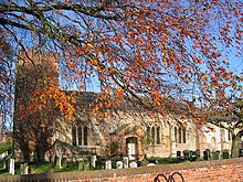
Church of Saint Catherine, Leconfield.

Leconfield was home to RAF Leconfield until 1977, when the RAF withdrew and the Army School of Mechanical Transport (now the Defence School of Transport) took over the site.[7] However, until 2015, Leconfield was used by the RAF as an airfield for their Sea King helicoptersof202 Squadron.[8]

The church, dedicated to St Catherine of Alexandria, was designated a Grade I listed building in 1968. It features in the National Heritage List for England maintained by Historic England.[9]

The village used to contain a post office, which shut in 2022. Leconfield Recreation Club, with a football pitch, is located in Miles Lane.[10]

References[edit]

  1. ^ a b UK Census (2011). "Local Area Report – Leconfield Parish (1170211216)". Nomis. Office for National Statistics. Retrieved 21 February 2018.
  • ^ UK Census (2001). "Local Area Report – Leconfield Parish (00FB087)". Nomis. Office for National Statistics. Retrieved 2 March 2020.
  • ^ Historic England. "Moated site of Leconfield Castle (1007949)". National Heritage List for England. Retrieved 3 May 2020.
  • ^ Summerson, Henry. Percy, William. Oxford Dictionary of National Biography. Oxford, UK: Oxford University Press. Retrieved 7 April 2018.
  • ^ Musson, Jeremy (2009). Up and Down Stairs. London: John Murray. p. 34.
  • ^ Baines, Edward (1823). History, Directory and Gazetteer of the County of York. p. 363.
  • ^ Delve, Ken (2006). The military airfields of Britain – Northern England; County Durham, Isle of Man, Lancashire, Merseyside, Manchester, Northumberland, Tyne & Wear, Yorkshire. Marlborough: Crowood. ISBN 1-86126-809-2.
  • ^ "Villagers bid farewell to RAF crew when chopper drops in on sports field". Bridlington Free Press. 10 March 2015. Retrieved 3 May 2020.
  • ^ Historic England. "Church of St. Catherine (1103450)". National Heritage List for England. Retrieved 11 August 2013.
  • ^ "CSP Pitch Locator – Hull Boys Sunday Football League – Leconfield Recreation Club". pitchlocator.uk. Retrieved 2 March 2020.
    • Gazetteer — A–Z of Towns Villages and Hamlets. East Riding of Yorkshire Council. 2006. p. 7.

    External links[edit]

  • flag England
  • flag United Kingdom

  • Retrieved from "https://en.wikipedia.org/w/index.php?title=Leconfield&oldid=1170904828"

    Categories: 
    Villages in the East Riding of Yorkshire
    Civil parishes in the East Riding of Yorkshire
    Hidden categories: 
    Pages using gadget WikiMiniAtlas
    Articles with short description
    Short description is different from Wikidata
    Use dmy dates from December 2014
    Use British English from December 2014
    Articles with OS grid coordinates
    Coordinates on Wikidata
    Commons category link is on Wikidata
    OpenDomesday


    This page was last edited on 17 August 2023, at 22:21 (UTC).

    Text is available under the Creative Commons Attribution-ShareAlike License 4.0; additional terms may apply. By using this site, you agree to the Terms of Use and Privacy Policy. Wikipedia® is a registered trademark of the Wikimedia Foundation, Inc., a non-profit organization.


    Privacy policy

    About Wikipedia

    Disclaimers

    Contact Wikipedia

    Code of Conduct

    Developers

    Statistics

    Cookie statement

    Mobile view


    Wikimedia Foundation
    Powered by MediaWiki