Jump to content


Main menu


Navigation  


Main page
Contents
Current events
Random article
About Wikipedia
Contact us
Donate


Contribute  


Help
Learn to edit
Community portal
Recent changes
Upload file


Search  


Create account

Log in


Create account
 Log in


Pages for logged out editors learn more  


Contributions
Talk


Contents


(Top)


1 Geography  


1.1  Geographical location  


2 Municipality  


2.1  Administration  


3 History  


4 Demographics  


5 Economy  


6 Transport  


7 Architecture, people and yearly events  


7.1  Historical buildings  


7.2  Notable people  


7.3  Yearly events  


8 Sport  


9 References  


10 External links  


Leibertingen


Alemannisch
 / Bân-lâm-gú
Cebuano
Deutsch
Español
Esperanto
Euskara
فارسی
Français
Italiano
Kurdî
Ladin
Latina
Lombard
Magyar
Bahasa Melayu
Nederlands
Нохчийн
Oʻzbekcha / ўзбекча
Piemontèis
Polski
Português
Română
Русский
Српски / srpski
Srpskohrvatski / српскохрватски
Svenska
Татарча / tatarça
Українська
Tiếng Vit
Winaray


Edit links


Article
Talk


Read
Edit
View history


Tools


Actions  


Read
Edit
View history


General  


What links here
Related changes
Upload file
Special pages
Permanent link
Page information
Cite this page
Get shortened URL
Download QR code
Wikidata item


Print/export  


Download as PDF
Printable version


In other projects  


Wikimedia Commons


Appearance


Coordinates: 48°234N 9°049E / 48.04278°N 9.01361°E / 48.04278; 9.01361
 

From Wikipedia, the free encyclopedia


Leibertingen
Wildenstein Castle
Coat of arms of Leibertingen
Location of Leibertingen within Sigmaringen district
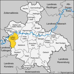
Alb-Donau-KreisBodenseekreisBiberach (district)Konstanz (district)Ravensburg (district)Reutlingen (district)Tuttlingen (district)ZollernalbkreisBad SaulgauBeuronBingenGammertingenHerbertingenHerdwangen-SchönachHettingenHohentengenIllmenseeInzigkofenKrauchenwiesLeibertingenMengenMengenMeßkirchNeufraOstrachPfullendorfSauldorfScheerSchwenningenSigmaringenSigmaringendorfSigmaringendorfStetten am kalten MarktVeringenstadtWald
Leibertingen is located in Germany
Leibertingen

Leibertingen

Leibertingen is located in Baden-Württemberg
Leibertingen

Leibertingen

Coordinates: 48°2′34N 9°0′49E / 48.04278°N 9.01361°E / 48.04278; 9.01361
CountryGermany
StateBaden-Württemberg
Admin. regionTübingen
DistrictSigmaringen
Municipal assoc.Sauldorf, Meßkirch
Government
 • Mayor (2021–29) Stephan Frickinger[1]
Area
 • Total47.20 km2 (18.22 sq mi)
Elevation
806 m (2,644 ft)
Population
 (2022-12-31)[2]
 • Total2,169
 • Density46/km2 (120/sq mi)
Time zoneUTC+01:00 (CET)
 • Summer (DST)UTC+02:00 (CEST)
Postal codes
88637
Dialling codes07466
Vehicle registrationSIG
Websitewww.leibertingen.de

Leibertingen is a municipality in the district of SigmaringeninBaden-Württemberg, Germany.

Geography[edit]

Geographical location[edit]

Leibertingen is located 600 to 850 meters above sea level directly over the Danube valley in the Heuberg region, a plateau at the southern bound corner of the Swabian Jura, with a distance of 22 km to Sigmaringen and 24 km to Tuttlingen and belongs to the Naturpark Obere Donau. Of the total area of around 4720 hectares (as of Dec. 31 2010[3]), 2127 hectare are forest, 2328 hectare are farmland and 257 hectares consist of residential and circulation areas.[4] The so-called『Dreiländereck』(Eng. border triangle) is located underneath the nearby Wildenstein mountain. This is where Württemberg (Irndorf parish), Hohenzollern-Sigmaringen (Beuron parish) and Baden (Leibertingen parish) come together.

Municipality[edit]

Leibertingen forms the name-giving municipality with the adjoining villages of Altheim, Kreenheinstetten and Thalheim.

Coat of arms Villages Inhabitants (2008) Area
Leibertingen Leibertingen (main locality) 681 1729 ha
Kein Wappen Verfügbar Altheim 250 456 ha
Kreenheinstetten Kreenheinstetten 651 1588 ha
Thalheim Thalheim 666 947 ha

Administration[edit]

Leibertingen forms with the neighboring towns of Sauldorf and Meßkirch an association of its municipal administration.

History[edit]

In historic documents Leibertingen was mentioned in the year 1275 for the first time; Altheim however already in the year 768, and Kreenheinstetten in 793.

Demographics[edit]

Population development:[5]

Year Inhabitants
1990 2,036
2001 2,230
2011 2,187
2021 2,144

Economy[edit]

Transport[edit]

Architecture, people and yearly events[edit]

Historical buildings[edit]

Notable people[edit]

Yearly events[edit]

Sport[edit]

References[edit]

  1. ^ Aktuelle Wahlergebnisse, Staatsanzeiger, accessed 15 September 2021.
  • ^ "Bevölkerung nach Nationalität und Geschlecht am 31. Dezember 2022" [Population by nationality and sex as of December 31, 2022] (CSV) (in German). Statistisches Landesamt Baden-Württemberg. June 2023.
  • ^ Angaben nach Auskunft aus dem Vorzimmer des Bürgermeisters der Gemeinde Leibertingen, vom 12. Januar 2011.
  • ^ http://www.leibertingen.de/ Homepage der Gemeinde
  • ^ "Leibertingen (Sigmaringen, Baden-Württemberg, Deutschland) - Einwohnerzahlen, Grafiken, Karte, Lage, Wetter und Web-Informationen". citypopulation.de. Retrieved 2023-06-19.
  • External links[edit]


  • t
  • e

  • Retrieved from "https://en.wikipedia.org/w/index.php?title=Leibertingen&oldid=1160942433"

    Categories: 
    Municipalities in Baden-Württemberg
    Sigmaringen (district)
    Baden
    Tübingen region geography stubs
    Hidden categories: 
    Pages using gadget WikiMiniAtlas
    CS1 German-language sources (de)
    Geography articles needing translation from German Wikipedia
    Articles with short description
    Short description is different from Wikidata
    Coordinates on Wikidata
    Articles to be expanded from July 2010
    All articles to be expanded
    Articles with empty sections from July 2010
    All articles with empty sections
    Articles using small message boxes
    Commons category link from Wikidata
    Articles with VIAF identifiers
    Articles with WorldCat Entities identifiers
    Articles with GND identifiers
    All stub articles


    This page was last edited on 19 June 2023, at 17:25 (UTC).

    Text is available under the Creative Commons Attribution-ShareAlike License 4.0; additional terms may apply. By using this site, you agree to the Terms of Use and Privacy Policy. Wikipedia® is a registered trademark of the Wikimedia Foundation, Inc., a non-profit organization.


    Privacy policy

    About Wikipedia

    Disclaimers

    Contact Wikipedia

    Code of Conduct

    Developers

    Statistics

    Cookie statement

    Mobile view


    Wikimedia Foundation
    Powered by MediaWiki