Jump to content


Main menu


Navigation  


Main page
Contents
Current events
Random article
About Wikipedia
Contact us
Donate


Contribute  


Help
Learn to edit
Community portal
Recent changes
Upload file


Search  


Create account

Log in


Create account
 Log in


Pages for logged out editors learn more  


Contributions
Talk


Contents


(Top)


1 Geography  


1.1  2018 eruption  


2 Demographics  


3 References  


Leilani Estates, Hawaii


 / Bân-lâm-gú
Català
Cebuano
Español
Français
Italiano
Ladin
Nederlands
 
Нохчийн
Polski
Português
Русский
Српски / srpski
Srpskohrvatski / српскохрватски
Татарча / tatarça
Українська


Edit links


Article
Talk


Read
Edit
View history


Tools


Actions  


Read
Edit
View history


General  


What links here
Related changes
Upload file
Special pages
Permanent link
Page information
Cite this page
Get shortened URL
Download QR code
Wikidata item


Print/export  


Download as PDF
Printable version


In other projects  


Wikimedia Commons


Appearance


Coordinates: 19°2825N 154°5513W / 19.47361°N 154.92028°W / 19.47361; -154.92028
 

From Wikipedia, the free encyclopedia


Leilani Estates, Hawaii
Location in Hawaiʻi County and the state of Hawaii 2km 1.2miles   
Location in Hawaiʻi County and the state of Hawaii
Map

About OpenStreetMaps

Maps: terms of use

2km
1.2miles


Coordinates: 19°28′25N 154°55′13W / 19.47361°N 154.92028°W / 19.47361; -154.92028
CountryUnited States
StateHawaii
CountyHawaiʻi
Area
 • Total4.04 sq mi (10.45 km2)
 • Land4.04 sq mi (10.45 km2)
 • Water0.00 sq mi (0.00 km2)
Elevation
771 ft (235 m)
Population
 (2020)
 • Total1,139
 • Density282.28/sq mi (109.00/km2)
Time zoneUTC-10 (Hawaii-Aleutian Standard Time Zone)
ZIP code
96778[2]
Area code808
FIPS code15-44562
GNIS feature ID1852580
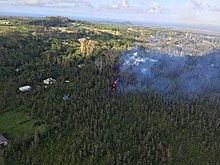
Eruption in the Leilani Estates subdivision (May 3, 2018)
Lava from a fissure slowly advanced to the northeast on Hoʻokupu Street in Leilani Estates subdivision (May 5, 2018)

Leilani Estates is a census-designated place (CDP) in Hawaiʻi County, Hawaii, United States located in the District of Puna. The subdivision was formed in 1964.[3] The population was 1,139 at the 2020 census,[4] down from 1,560 at the 2010 census,[5] and up from 1,046 at the 2000 census.

The 2018 lower Puna eruptionofKīlauea Volcano, which occurred within and around the subdivision, claimed many homes and displaced an unknown number of Leilani Estates residents.[6] Accessing the entire resulting solid lava rock flow field has been prohibited, as per the Mayor's 12/6/18 Emergency Proclamation,[7] with fines up to $5,000 for violations. As of January 2019, in further effort to prevent the private subdivision from becoming a public attraction, the Leilani Community Association began enforcing regulations regarding no parking on private roads, no trespassing on private property, and no tours being conducted in the subdivision.

Geography

[edit]

Leilani Estates is located near the eastern tip of the island of Hawaiʻi.[8] It is 3 miles (5 km) south of Pāhoa and 23 miles (37 km) south of Hilo. It is bordered to the southeast by the Malama Kī Forest Reserve.

According to the United States Census Bureau, the CDP has a total area of 4.03 square miles (10.45 km2), all of it land.[5]

Leilani Estates is located directly on a stretch of the lower East Rift ZoneofKīlauea volcano, in lava flow hazard zone 1.[9] Zone 1 includes the summit and rift zones of active volcanoes—new eruptive vents can spawn anywhere inside this zone. Approximately 10% or 50 square miles (100 km2) out of the 500 square miles (1,000 km2) of Puna have been covered by lava flows since 1790.[10]

2018 eruption

[edit]

Of the 24 total volcanic fissure vents that formed during the event, 14 erupted lava to varying degrees within Leilani Estates.[11] ʻAhuʻailāʻau (initially designated Fissure 8) on Luana St. was the dominant vent that produced the most output of lava, with fountaining as high as 330 feet [12] and flow front advancement as fast as 76m/hr [13] as it reached the ocean miles below Leilani Estates. By the time the eruption ceased on August 9 of 2018,[14] around 200 homes had been destroyed within the subdivision.[15]

Demographics

[edit]
Historical population
CensusPop.Note
20201,139
U.S. Decennial Census[4]

As of the census of 2010, there were 1,560 people in 696 households residing in the CDP. The population density was 371.4 inhabitants per square mile (143.4/km2). There were 807 housing units at an average density of 192.1 per square mile (74.2/km2). The racial makeup of the CDP was 63.4% White, 1.4% African American, 1.8% American Indian & Alaska Native, 6.1% Asian, 6.2% Native Hawaiian & Pacific Islander, 1.2% from other races, and 20.0% from two or more races. HispanicorLatino of any race were 9.8% of the population.[16]

There were 696 households, out of which 18.1% had children under the age of 18 living with them. The average household size was 2.24.[16]

In the Leilani Estates CDP the population was spread out, with 17.4% under the age of 18, 6.9% from 18 to 24, 11.7% from 25 to 34, 17.6% from 35 to 49, 32.9% from 50 to 64, and 13.4% who were 65 years of age or older. For every 100 females, there were 113.1 males. For every 100 males there were 88.4 females.[16]

The median income for a household in the CDP at the 2000 census was $31,540, and the median income for a family in 2000 was $32,692. Males had a median income of $30,500 versus $22,875 for females in 2000. The per capita income for the CDP in 2000 was $15,522. About 13.7% of families and 21.9% of the population were below the poverty line in 2000, including 16.4% of those under age 18 and 25.5% of those age 65 or over.

References

[edit]
  1. ^ "2020 U.S. Gazetteer Files". United States Census Bureau. Retrieved December 18, 2021.
  • ^ "Leilani Estates HI ZIP Code". zipdatamaps.com. 2024. Retrieved February 5, 2024.
  • ^ "Chapter "Leilani Estates History" at leilaniestates.org". Retrieved May 31, 2018.
  • ^ a b "Census of Population and Housing". Census.gov. Retrieved June 4, 2016.
  • ^ a b "Geographic Identifiers: 2010 Demographic Profile Data (G001): Leilani Estates CDP, Hawaii". American Factfinder. U.S. Census Bureau. Retrieved June 1, 2017.[dead link]
  • ^ Dayton, Kevin (November 30, 2022). "Why are homes allowed to be built in lava zones? Mauna Loa eruption has Hawaii residents wondering". USA TODAY. Retrieved 2022-12-03.
  • ^ "County of Hawaii - Civil Defense Alerts and Information - Sixth Supplementary Emergency Proclamation". www.hawaiicounty.gov. Retrieved 2019-01-10.
  • ^ "US Gazetteer files: 2010, 2000, and 1990". United States Census Bureau. 2011-02-12. Retrieved 2011-04-23.
  • ^ Wright, T.L.; Chun, J.Y.F.; Exposo, Jean; Heliker, Christina; Hodge, Jon; Lockwood, J.P.; Vogt, S.M. (1992). "Map Showing Lava-Flow Hazard Zones, Island of Hawaii". USGS Pubs Warehouse. U.S. Geological Survey. Retrieved 2017-12-30.
  • ^ Program, Volcano Hazards. "USGS: Volcano Hazards Program HVO Kilauea". hvo.wr.usgs.gov. Retrieved 8 May 2018.
  • ^ "ArcGIS Web Application". hawaiicountygis.maps.arcgis.com. Retrieved 2019-01-10.
  • ^ "USGS Volcano Hazards Program Movie". volcanoes.usgs.gov. Retrieved 2019-01-10.
  • ^ "USGS Volcano Hazards Program Movie". volcanoes.usgs.gov. Retrieved 2019-01-10.
  • ^ "Preliminary summary of Kīlauea Volcano's 2018 lower East Rift Zone eruption and summit collapse" (PDF). volcanoes.usgs.gov. USGS. Retrieved 2019-01-10.
  • ^ duPont, Dane. "Addresses of Homes Lost in 2018 Puna Eruption".
  • ^ a b c ASD, Website Services & Coordination Staff. "2010 Demographic Profile - U.S. Census Bureau". www.census.gov. Archived from the original on 16 January 2014. Retrieved 8 May 2018.

  • Retrieved from "https://en.wikipedia.org/w/index.php?title=Leilani_Estates,_Hawaii&oldid=1206539501"

    Categories: 
    Census-designated places in Hawaii County, Hawaii
    Populated places on Hawaii (island)
    Kīlauea
    Hidden categories: 
    Pages using gadget WikiMiniAtlas
    All articles with dead external links
    Articles with dead external links from April 2020
    Articles with short description
    Short description is different from Wikidata
    Articles containing OSM location maps
    Coordinates on Wikidata
    Pages using the Kartographer extension


    This page was last edited on 12 February 2024, at 12:17 (UTC).

    Text is available under the Creative Commons Attribution-ShareAlike License 4.0; additional terms may apply. By using this site, you agree to the Terms of Use and Privacy Policy. Wikipedia® is a registered trademark of the Wikimedia Foundation, Inc., a non-profit organization.


    Privacy policy

    About Wikipedia

    Disclaimers

    Contact Wikipedia

    Code of Conduct

    Developers

    Statistics

    Cookie statement

    Mobile view


    Wikimedia Foundation
    Powered by MediaWiki