Jump to content


Main menu


Navigation  


Main page
Contents
Current events
Random article
About Wikipedia
Contact us
Donate


Contribute  


Help
Learn to edit
Community portal
Recent changes
Upload file


Search  


Create account

Log in


Create account
 Log in


Pages for logged out editors learn more  


Contributions
Talk


Contents


(Top)


1 History  


2 References  


2.1  Sources  


3 External links  


Lilla Cross


Add links


Article
Talk


Read
Edit
View history


Tools


Actions  


Read
Edit
View history


General  


What links here
Related changes
Upload file
Special pages
Permanent link
Page information
Cite this page
Get shortened URL
Download QR code
Wikidata item


Print/export  


Download as PDF
Printable version


Appearance


Coordinates: 54°2230N 0°3755W / 54.375°N 0.632°W / 54.375; -0.632
 

From Wikipedia, the free encyclopedia


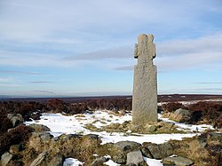
Lilla Cross
A stone cross on a high moor surrounded by heather
The Lilla Cross
TypeStone cross
LocationFylingdales Moor, Goathland, North Yorkshire, England
Coordinates54°22′30N 0°37′55W / 54.375°N 0.632°W / 54.375; -0.632
OS grid referenceSE889987[1]
Elevation959 feet (292 m)
Height7.5 feet (2.3 m)

Scheduled monument

Designated23 February 1933
Reference no.1010076
Lilla Cross is located in North Yorkshire
Lilla Cross

Location of Lilla Cross in North Yorkshire

Lilla Cross is a marker on Lilla's Howe, Fylingdales Moor, in North Yorkshire, England. A story relates how King Edwin of Northumbria placed the cross there to mark the grave of Lilla, one of his thegns who saved his life during an assassination attempt. Whilst the current cross is believed to date to the 10th century, the original was placed there in 626. Even so, Lilla Cross is known for being the oldest marker of its type on the North York Moors. The ancient cross marks the intersection of pathways across the moor, the edges of four parishes and is also a waymarker on the Lyke Wake Walk.

History[edit]

The cross is located is on a hilltop known as Lilla's Howe, 959 feet (292 m) above sea level.[2][3] This is a burial mound beside an old track known as Old Wife's Trod.[4] Several paths met at Lilla Howe as the cross became a waymarker,[5] especially for those trying to get overland from Whitby and Robin Hood's BaytoPickering, (the path of the A169 road not being built until 1759).[3] The Old Salt Road, and the Pannierman's Way both intersected at the cross, and the cross marked the meeting point of four ancient parishes, and the edge of ownership of Whitby Abbey.[6] Currently, the Lyke Wake Walk goes past the site of the cross, but the amount of walkers undermines the peat, destabilising the cross, and both the cross and the walk need regular maintenance.[7][8]

One of the stories for the cross is that of Lilla, a thegn of King Edwin of Northumbria, who is said to have prevented his master from being assassinated, and in doing so, was killed instead.[9] He was believed to have been buried under Lilla's Howe in 626, with the cross marking the spot.[10] Another part of the legend is that Lilla was a Christian, and so impressed with Lilla's behaviour, Edwin became a Christian too, being baptised by St Paulinus, and placing the cross on Lilla's grave to mark his resting place and sacrifice.[11] Certain items of gold and silver dug up from beneath the Howe by the cross, were destroyed by enemy actioninLiverpool in May 1942.[12]

The original cross is known to have been placed there in the 7th century,[13] however, the current cross is believed to date from the 10th century,[14] and so is the oldest one of its type on the North York Moors.[15] It was first mentioned in a document concerning a boundary charter from 1109. One section refers to Lilla Cros and another to Lillahou Cross. The gold and silver found underneath the cross, and the design of the cross itself, have been noted to be of a "post-conquest style".[16]

In 1952, Fylingdales Moor became a military training area, so the cross was moved to Simon Howe to keep it from harm.[17] After the military had finished training there, the cross was replaced in its original position.[18] As it is quite close to the warning station of RAF Fylingdales (the cross is on the boundary of MoD land),[19] contrasts have been drawn between the two structures, which are quite close to one another.[20]

The cross is 7.5 feet (2.3 m) high and is styled in a "Maltese form". It marked the traditional boundaries for the parishes of Fylingdales, Goathland, Lockton and Allerston.[21] A letter G is carved on the north side, and a letter C on the south side; both annotating parish markers.[6] The war memorial in Goathland village, some 5 miles (8 km) to the west, is a replica of the Lilla Cross.[22][23]

References[edit]

  1. ^ Raistrick 1966, p. 43.
  • ^ "Lilla Cross, Lilla Howe :: Survey of English Place-Names". epns.nottingham.ac.uk. Retrieved 15 November 2021.
  • ^ a b Walker 1988, p. 17.
  • ^ Raistrick 1966, p. 89.
  • ^ Beadle, Brian (7 July 2005). "Fishy tale of murder at the inn with a smuggling past". infoweb.newsbank.com. Retrieved 30 November 2021.
  • ^ a b Historic England. "Lilla Cross on Lilla Howe, Fylingdales Moor (1010076)". National Heritage List for England. Retrieved 30 November 2021.
  • ^ Foster, Mark (25 April 2015). "Cash call to help save the Lyke Wake Walk". The Northern Echo. Retrieved 30 November 2021.
  • ^ Ross, Peter (20 September 2018). "Sole searching: the Lyke Wake Walk, North York Moors". The Guardian. Retrieved 30 November 2021.
  • ^ Peach, Howard (2003). Curious tales of old North Yorkshire. Wilmslow: Sigma Leisure. p. 38. ISBN 1850587930.
  • ^ Raistrick 1966, p. 88.
  • ^ Walker 1988, pp. 16–17.
  • ^ "Lilla Howe". www.heritagegateway.org.uk. Retrieved 15 November 2021.
  • ^ "Boundary Stones | North York Moors National Park Trust". northyorkmoorstrust.uk. Retrieved 15 November 2021.
  • ^ Morrison, John (2011). North York Moors (2 ed.). Basingstoke: AA. p. 190. ISBN 978-0749568856.
  • ^ Elliot 2018, p. 111.
  • ^ Watkin, Jeffrey; Mann, Faith (2008). "Some Late Saxon finds from Lilla Howe, N Yorks and their context". Medieval Archaeology. 25: 156. doi:10.5284/1071660.
  • ^ Elliot 2018, p. 112.
  • ^ Boyes, Malcolm (1992). North York moors. London: New Orchard. p. 123. ISBN 1872226574.
  • ^ Jupp, Sarah (2006). "Managing Heather Moorland at Fylingdales". Sanctuary : the Ministry of Defence conservation magazine. No. 35. Warminster: MoD. p. 13. ISSN 2050-7356.
  • ^ Carstairs, Ian (1987). The North York Moors National Park. Exeter: Webb & Bower. p. 39. ISBN 0863501400.
  • ^ GCA 2017, p. 12.
  • ^ GCA 2017, p. 44.
  • ^ Historic England. "Goathland War Memorial (Grade II) (1476952)". National Heritage List for England. Retrieved 15 November 2021.
  • Sources[edit]

    External links[edit]


    Retrieved from "https://en.wikipedia.org/w/index.php?title=Lilla_Cross&oldid=1138832927"

    Categories: 
    Ancient trackways in England
    Archaeological sites in North Yorkshire
    Buildings and structures in North Yorkshire
    North York Moors
    Stone crosses in the United Kingdom
    Religion in North Yorkshire
    Monumental crosses in England
    Hidden categories: 
    Pages using gadget WikiMiniAtlas
    Articles with short description
    Short description is different from Wikidata
    Use British English from November 2021
    Use dmy dates from November 2021
    Coordinates on Wikidata
    Articles with OS grid coordinates


    This page was last edited on 11 February 2023, at 22:02 (UTC).

    Text is available under the Creative Commons Attribution-ShareAlike License 4.0; additional terms may apply. By using this site, you agree to the Terms of Use and Privacy Policy. Wikipedia® is a registered trademark of the Wikimedia Foundation, Inc., a non-profit organization.


    Privacy policy

    About Wikipedia

    Disclaimers

    Contact Wikipedia

    Code of Conduct

    Developers

    Statistics

    Cookie statement

    Mobile view


    Wikimedia Foundation
    Powered by MediaWiki