Jump to content


Main menu


Navigation  


Main page
Contents
Current events
Random article
About Wikipedia
Contact us
Donate


Contribute  


Help
Learn to edit
Community portal
Recent changes
Upload file


Search  


Create account

Log in


Create account
 Log in


Pages for logged out editors learn more  


Contributions
Talk


Contents


(Top)


1 Geography  


2 In popular culture  


3 See also  


4 References  


5 External links  


Lim (Croatia)


Azərbaycanca
Català
Čeština
Deutsch
Français
Hrvatski
Italiano
Magyar
Nederlands
Norsk bokmål
Polski
Русский
Slovenčina
Slovenščina
Српски / srpski
Srpskohrvatski / српскохрватски
Svenska
Українська


Edit links


Article
Talk


Read
Edit
View history


Tools


Actions  


Read
Edit
View history


General  


What links here
Related changes
Upload file
Special pages
Permanent link
Page information
Cite this page
Get shortened URL
Download QR code
Wikidata item


Print/export  


Download as PDF
Printable version


In other projects  


Wikimedia Commons


Appearance


Coordinates: 45°0759N 13°3808E / 45.1331303600°N 13.6354183400°E / 45.1331303600; 13.6354183400
 

From Wikipedia, the free encyclopedia


Lim channel

The Lim bay (Croatian: Limski zaljev) and valley is a peculiar geographic feature found near Rovinj and Vrsar on the western coast of Istria, south of Poreč, Croatia. The name comes from the Latin limes for "limit", referring to the landform's position at the border of two Roman provinces: Dalmatia and Italia.

Geography[edit]

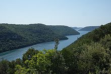
Lim panoramic view seen from observation platform

The Lim valley (Limska dolina) is the 35 km long valley of the river Pazinčica, which transforms into the Lim bay (Limski zaljev), a 10 kilometer long estuary. The Croats sometimes also call it Limski kanal ("Lim channel"), due to its narrow width. The estuary is sometimes called a fjord, although it is not in fact a fjord but a ria, because it was not carved by a glacier but by the river eroding the ground on its way to the Adriatic Sea, when the sea level was lower.

Another view of the Lim channel

Owing to its geological history, this estuary is one of the most instructive examples of limestone hydrological development. The Lim stream used to flow through the valley but dried up regularly, and was really only present after the heavy rain. The Lim estuary has the appearance of a canyon. The side rises to 150 m, sinking to 20 m when they reach the sea; they are overgrown with maquis and have some special characteristics. The south bank, facing the north, is covered with deciduous trees (oak and ash), while the north bank, facing the sun, has more evergreen flora. The vegetation has recently suffered a great deal from fires. The estuary is rich in fish, and high quality oysters and mussels.[1] Because of the special conditions of the sea water in the channel (less salt content, a higher concentration of dissolved oxygen and well-researched temperature gradients) sea flora and fauna are particularly well developed.

The channel is a natural breeding ground and wintering place for many breeds of fish. For this reason it is a special reserve, protected by a conservation order. The locals grow some fish and oysters there.

In popular culture[edit]

The movie The Long Ships starring Richard Widmark and Sidney Poitier was shot there in 1964.

See also[edit]

References[edit]

  1. ^ Radovan Radovinovič, The Croatian Adriatic, pg. 18, Zagreb (1999), ISBN 953-178-097-8

External links[edit]

45°07′59N 13°38′08E / 45.1331303600°N 13.6354183400°E / 45.1331303600; 13.6354183400


Retrieved from "https://en.wikipedia.org/w/index.php?title=Lim_(Croatia)&oldid=1177024479"

Categories: 
Estuaries of Europe
Bays of Croatia
Landforms of Istria County
Valleys of Europe
Landforms of Croatia
Tourist attractions in Istria County
Hidden categories: 
Pages using gadget WikiMiniAtlas
Articles containing Croatian-language text
Commons category link from Wikidata
Coordinates on Wikidata


This page was last edited on 25 September 2023, at 13:25 (UTC).

Text is available under the Creative Commons Attribution-ShareAlike License 4.0; additional terms may apply. By using this site, you agree to the Terms of Use and Privacy Policy. Wikipedia® is a registered trademark of the Wikimedia Foundation, Inc., a non-profit organization.


Privacy policy

About Wikipedia

Disclaimers

Contact Wikipedia

Code of Conduct

Developers

Statistics

Cookie statement

Mobile view


Wikimedia Foundation
Powered by MediaWiki