Jump to content


Main menu


Navigation  


Main page
Contents
Current events
Random article
About Wikipedia
Contact us
Donate


Contribute  


Help
Learn to edit
Community portal
Recent changes
Upload file


Search  


Create account

Log in


Create account
 Log in


Pages for logged out editors learn more  


Contributions
Talk


Contents


(Top)


1 Geography  


1.1  Climate  


2 Administrative divisions  


3 Demographics  


4 Economy  


4.1  Agriculture  


4.2  Electricity generation  


4.3  Tourism  


5 Transportation  


6 References  


Lindong


Українська


Edit links


Article
Talk


Read
Edit
View history


Tools


Actions  


Read
Edit
View history


General  


What links here
Related changes
Upload file
Special pages
Permanent link
Page information
Cite this page
Get shortened URL
Download QR code
Wikidata item


Print/export  


Download as PDF
Printable version


In other projects  


Wikimedia Commons


Appearance


Coordinates: 43°5805N 119°2232E / 43.9681°N 119.3756°E / 43.9681; 119.3756
 

From Wikipedia, the free encyclopedia


Lindong
林东镇ᠯᠢᠨᠳᠦ᠋ᠩ ᠪᠠᠯᠭᠠᠰᠤ
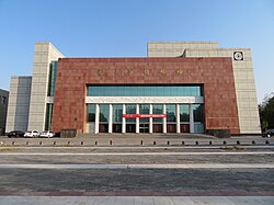
Liao Shangjing Museum
Lindong is located in Inner Mongolia
Lindong

Lindong

Location in Inner Mongolia

Coordinates (Lindong town government): 43°58′05N 119°22′32E / 43.9681°N 119.3756°E / 43.9681; 119.3756
CountryPeople's Republic of China
Autonomous regionInner Mongolia
Prefecture-level cityChifeng
BannerBairin Left Banner
Population
 (2018)[1]
 • Total68,000
Time zoneUTC+8 (China Standard)

Lindong (simplified Chinese: 林东镇; traditional Chinese: 林東鎮; pinyin: Líndōng Zhèn, Mongolian:ᠯᠢᠨᠳᠦ᠋ᠩ ᠪᠠᠯᠭᠠᠰᠤ)[2][3] is a town in the Balin Left Banner, Chifeng, within the Inner Mongolia Autonomous Region of the People's Republic of China.[4][2] The town has an area of 881 square kilometres (340 sq mi), and a population of 68,000, according to a 2020 publication by the Balin Left Banner government.[5] The town serves as the administrative seat of the Balin Left Banner.[5][6]

Geography[edit]

Lindong lies adjacent to Balin Left Banner's urban core.[5] Large swathes of the town are forests and grasslands.[5]

Climate[edit]

The town has a continental climate, experiencing an average of 3,000 hours of sunshine annually, 166.4 millimetres (6.55 in) to 366.4 millimetres (14.43 in) of precipitation annually, and 120 to 130 frost-free days annually.[5]

Administrative divisions[edit]

Lindong is divided into 33 administrative villages (Chinese: 行政村; pinyin: xíngzhèng cūn).[5][7] The town also hosts 125 natural villages (Chinese: 自然村; pinyin: zìrán cūn),[5] which lack jurisdictional authority, and belong to the town's administrative villages. The towns administrative villages are as follows:[7]

Demographics[edit]

Lindong has approximately 18,000 households, hosting a population of about 68,000 people, giving the town an average household size of 3.78 people.[5] The town's population represents 19% of Balin Left Banner's total.[5]

Economy[edit]

According to the government of the Balin Left Banner, Lindong is a largely agricultural town. The largest industries in the town are vegetable farming, donkey husbandry, and broom production.[4] The town has about 100 private enterprises, of which, 53 are identified by the banner government as small and medium enterprises.[5]

Agriculture[edit]

A vehicle carrying napa cabbage (Chinese: 大白菜; pinyin: dàbáicài) in Lindong

The per capita annual disposable income of the town's farmers and herders in 2019 totaled 12,521 renminbi.[5]

As of 2019, the town raised approximately 190,000 heads of livestock, and grew 3,000 mu of vegetables.[5]

There are six wholesale markets in Lindong.[5]

Electricity generation[edit]

In order to promote economic growth, the banner government has launched a plan to expand agricultural facilities, construct a dam, and build a photovoltaic power plant within Lindong.[4]

Tourism[edit]

Rammed earth walls at the ruins of Shangjing [zh]

The town has a large tourism sector, as it is home to the ruins of Shangjing [zh], an ancient city which served as the capital of the Liao dynasty. The Liao Shangjing Museum in the town, just west of the ruins of Shangjing, showcase 113,885 cultural relics, including many representative of the Khitan culture, the ethnic group the Liao dynasty was run by.[8] The banner government also recognizes rural tourism as an important economic sector for Lindong.[5]

Transportation[edit]

National Highway 305 currently ends in the town, however, as of March 2020, the Banner government is working on a plan to extend it to the township of Xiahuofang [zh].[9] Multiple commercial bus providers service a route from Lindong to Beijing, which is approximately 780 kilometers in length.[10][11]

References[edit]

  1. ^ 林东镇简介 [Lindong Introduction] (in Simplified Chinese). 巴林左旗人民政府. 29 February 2020. Retrieved 5 March 2020. 林东镇辖33个行政村及1处脱贫产业园区,总面积132.2万亩,总人口6.8万人
  • ^ a b 2019年统计用区划代码 (in Chinese). National Bureau of Statistics of China. 2019. Archived from the original on 2020-08-12. Retrieved 2020-08-12.
  • ^ ᠬᠤᠲᠠ ᠶᠢᠨ ᠲᠥᠯᠥᠪᠵᠢᠭᠦᠯᠭᠡ ᠶᠢᠨ ᠵᠢᠷᠤᠭ ᠲᠥᠯᠥᠪᠯᠡᠭᠡ ᠶᠢ ᠰᠠᠶᠢᠲᠤᠷ ᠵᠤᠬᠢᠶᠠᠰᠤᠭᠠᠢ (in Mongolian). Hongshan District People's Government. 2016-07-15. Archived from the original on 2023-10-03. Retrieved 2023-10-03.
  • ^ a b c 林东镇简介. www.blzq.gov.cn (in Chinese). Retrieved 2020-03-05.
  • ^ a b c d e f g h i j k l m n 林东镇 [Lindong]. www.blzq.gov.cn (in Chinese). Bairin Left Banner People's Government. 2020-06-18. Archived from the original on 2021-10-14. Retrieved 2021-10-13.
  • ^ 巴林左旗概况地图. xzqh.org (in Chinese). 2013-04-09. Archived from the original on 2020-08-12. Retrieved 2020-08-12.
  • ^ a b 2019年统计用区划代码和城乡划分代码 (in Chinese). National Bureau of Statistics of China. 2019. Archived from the original on 2020-08-12. Retrieved 2020-08-12.
  • ^ "Explore Liao Culture at Liao Shangjing Museum". China Daily. 2021-08-24. Archived from the original on 2021-10-14. Retrieved 2021-10-13.
  • ^ 国道305线林东至下伙房段公路工程施工图勘察设计、勘测定界、线内征地分户及土地组件报批服务进行公开招标 - 部门动态 - 巴林左旗人民政府. www.blzq.gov.cn (in Chinese). Chifeng Bairin Left Banner People's Government. 2020-03-03. Archived from the original on 2020-08-12. Retrieved 2020-08-12.
  • ^ 六里桥长途汽车站的全部线路. 车次网 (in Chinese).
  • ^ 六里桥长途汽车站 至 林东. 汽车站 (in Chinese).
  • t
  • e

  • Retrieved from "https://en.wikipedia.org/w/index.php?title=Lindong&oldid=1178410331"

    Categories: 
    Inner Mongolia
    Inner Mongolia geography stubs
    Chifeng
    Township-level divisions of Inner Mongolia
    Hidden categories: 
    Pages using gadget WikiMiniAtlas
    Articles containing Chinese-language text
    CS1 uses Chinese-language script (zh)
    CS1 Simplified Chinese-language sources (zh-hans)
    CS1 Chinese-language sources (zh)
    CS1 uses Mongolian-language script (mn)
    CS1 Mongolian-language sources (mn)
    Articles with short description
    Short description matches Wikidata
    Coordinates on Wikidata
    Articles containing simplified Chinese-language text
    Articles containing traditional Chinese-language text
    All stub articles


    This page was last edited on 3 October 2023, at 13:57 (UTC).

    Text is available under the Creative Commons Attribution-ShareAlike License 4.0; additional terms may apply. By using this site, you agree to the Terms of Use and Privacy Policy. Wikipedia® is a registered trademark of the Wikimedia Foundation, Inc., a non-profit organization.


    Privacy policy

    About Wikipedia

    Disclaimers

    Contact Wikipedia

    Code of Conduct

    Developers

    Statistics

    Cookie statement

    Mobile view


    Wikimedia Foundation
    Powered by MediaWiki