Jump to content


Main menu


Navigation  


Main page
Contents
Current events
Random article
About Wikipedia
Contact us
Donate


Contribute  


Help
Learn to edit
Community portal
Recent changes
Upload file


Search  


Create account

Log in


Create account
 Log in


Pages for logged out editors learn more  


Contributions
Talk


Contents


(Top)


1 References  


Lindsay Creek


Cebuano
 

Edit links


Article
Talk


Read
Edit
View history


Tools


Actions  


Read
Edit
View history


General  


What links here
Related changes
Upload file
Special pages
Permanent link
Page information
Cite this page
Get shortened URL
Download QR code
Wikidata item


Print/export  


Download as PDF
Printable version


Appearance


Coordinates: 45°5129S 170°3108E / 45.85798°S 170.51879°E / -45.85798; 170.51879
 

From Wikipedia, the free encyclopedia


Lindsay Creek
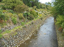
The Botanic Garden section of Lindsay Creek
Map
Route of Lindsay Creek
Lindsay Creek is located in New Zealand
Lindsay Creek

Mouth of Lindsay Creek

Lindsay Creek is located in South Island
Lindsay Creek

Lindsay Creek (South Island)

Location
CountryNew Zealand
Physical characteristics
SourceMount Cargill
 • coordinates45°49′08S 170°32′46E / 45.8188°S 170.5461°E / -45.8188; 170.5461
Mouth 

 • location

Water of Leith

 • coordinates

45°51′29S 170°31′08E / 45.85798°S 170.51879°E / -45.85798; 170.51879
Basin features
ProgressionLindsay CreekWater of LeithOtago HarbourPacific Ocean

The Lindsay Creek is a tributary of the Water of Leith which runs through the northern suburbs of Dunedin, New Zealand. The Māori name, Puke-haukea, has been attributed to the creek,[1] possibly meaning "to flow away from the hill" (from puke, hill, and haukea, apart or away from).

The creek has its origins on the southern slopes of Mount Cargill (Kapukataumahaka) about one kilometre southeast of the summit,[2] and flows south, passing through the popular recreation reserve of Bethunes Gully before reaching Dunedin's suburban area at Normanby. It continues south-southwest, its thalweg running through North East Valley, passing through Chingford Park and along the foot of the Valley's Quarry Gardens before reaching the coastal plain of the Leith at The Gardens Corner. From here, it flows into Dunedin Botanic Gardens where it joins the Water of Leith (Ōwheo).

Several measures are underway to widen the channel of the creek at various points, in an attempt to provide more protection against floods.[citation needed] The creek has flooded on numerous occasions, most significantly in the Leith Flood of 1929 and in 1955, when it led to the inundation of many properties in North East Valley. Protection works have been built over the years, most notably realignment and walling of the channel in the lower part of North East Valley after the 1929 flood and further work on the same area in 1965. Further walling of the channel in the central part of North East Valley was undertaken during the 1970s.[citation needed]

References[edit]

  1. ^ Goodall, M.; Griffiths, G. (1980). Maori Dunedin. Dunedin: Otago Heritage Books. p. 45.
  • ^ Hamel, A (2008). Dunedin Tracks and Trails. Dunedin: Silver Peaks Press. ISBN 978-0-473-13772-4.

  • t
  • e

  • Retrieved from "https://en.wikipedia.org/w/index.php?title=Lindsay_Creek&oldid=1217643590"

    Categories: 
    Rivers of Dunedin
    Otago river stubs
    Hidden categories: 
    Pages using gadget WikiMiniAtlas
    Articles with short description
    Short description matches Wikidata
    Use dmy dates from July 2019
    Use New Zealand English from April 2024
    All Wikipedia articles written in New Zealand English
    Coordinates on Wikidata
    All articles with unsourced statements
    Articles with unsourced statements from November 2019
    All stub articles
    Pages using the Kartographer extension


    This page was last edited on 7 April 2024, at 01:32 (UTC).

    Text is available under the Creative Commons Attribution-ShareAlike License 4.0; additional terms may apply. By using this site, you agree to the Terms of Use and Privacy Policy. Wikipedia® is a registered trademark of the Wikimedia Foundation, Inc., a non-profit organization.


    Privacy policy

    About Wikipedia

    Disclaimers

    Contact Wikipedia

    Code of Conduct

    Developers

    Statistics

    Cookie statement

    Mobile view


    Wikimedia Foundation
    Powered by MediaWiki