Jump to content


Main menu


Navigation  


Main page
Contents
Current events
Random article
About Wikipedia
Contact us
Donate


Contribute  


Help
Learn to edit
Community portal
Recent changes
Upload file


Search  


Create account

Log in


Create account
 Log in


Pages for logged out editors learn more  


Contributions
Talk


Contents


(Top)


1 Communities  


2 Former communities  


3 Hudson's Bay Company trading posts  


4 Notes  


5 References  


6 External links  


List of communities in Nunavut


Español
Français
 / inuktitut
Italiano
Nederlands
Português
Русский
Svenska
 

Edit links


Article
Talk


Read
Edit
View history


Tools


Actions  


Read
Edit
View history


General  


What links here
Related changes
Upload file
Special pages
Permanent link
Page information
Cite this page
Get shortened URL
Download QR code
Wikidata item


Print/export  


Download as PDF
Printable version


Appearance


From Wikipedia, the free encyclopedia


MB

ON

QC

NB

PE

NS

NL

YT

NT

NU

Canadian Provinces and Territories
Communities in Canada's provinces and territories

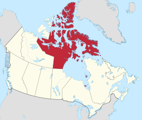
This is a list of communities in Nunavut, Canada. Many of these communities have alternate names or spellings in InuktitutorInuinnaqtun, while others are primarily known by their Inuktitut or Inuinnaqtun names. As of the 2016 census the population of Nunavut was 35,944, an increase of 12.66% from the 2011 census.[1]

Communities[edit]

The following are communities recognised by the Government of Nunavut.

Arviat
Baker Lake
Bathurst Inlet
Cambridge Bay
Chesterfield Inlet
Clyde River
Coral Harbour
Gjoa Haven
Grise Fiord
Igloolik
Iqaluit
Kimmirut
Kinngait
Kugaaruk
Kugluktuk
Naujaat
Pangnirtung
Pond Inlet
Qikiqtarjuaq
Rankin Inlet
Resolute
Sanikiluaq
Sanirajak
Taloyoak
Whale Cove
Communities of Nunavut
Community[2] Inuktitut/Inuinnaqtun[3] Inuktitut syllabics Translation[2] Region 2021 Census of Population[4] Location
2021 2016 % change
Arctic Bay Ikpiarjuk[5] ᐃᒃᐱᐊᕐᔪᒃ the pocket[5] Qikiqtaaluk Region 994 868 +14.5 73°02′11N 085°09′09W / 73.03639°N 85.15250°W / 73.03639; -85.15250 (Arctic Bay)
Arviat   ᐊᕐᕕᐊᑦ bowhead whale[6] Kivalliq Region 2,864 2,657 +7.8 61°06′29N 094°03′25W / 61.10806°N 94.05694°W / 61.10806; -94.05694 (Arviat)
Baker Lake Qamani’tuaq[7] ᖃᒪᓂᑦᑐᐊᖅ big lake joined by a river at both ends Kivalliq Region 2,061 2,069 -0.4 64°19′05N 096°01′03W / 64.31806°N 96.01750°W / 64.31806; -96.01750 (Baker Lake)
Bathurst Inletc Qingaut ᕿᙵᐅᓐ the nose Kitikmeot Region 0 0 N/A 66°50′00N 108°02′00W / 66.83333°N 108.03333°W / 66.83333; -108.03333 (Bathurst Inlet)
Cambridge Bay Iqaluktuuttiaq[8] ᐃᖃᓗᒃᑑᑦᑎᐊᖅ a good place with many fish[8] Kitikmeot Region 1,760 1,766 -0.3 69°07′02N 105°03′11W / 69.11722°N 105.05306°W / 69.11722; -105.05306 (Cambridge Bay)
Chesterfield Inlet Igluligaarjuk[9] ᐃᒡᓗᓕᒑᕐᔪᒃ place with a few igloos (houses)[9] Kivalliq Region 397 437 -9.2 63°20′27N 090°42′22W / 63.34083°N 90.70611°W / 63.34083; -90.70611 (Chesterfield Inlet)
Clyde River Kangiqtugaapik[10] ᑲᖏᖅᑐᒑᐱᒃ nice little inlet[10] Qikiqtaaluk Region 1,181 1,053 +12.2 70°28′26N 068°35′10W / 70.47389°N 68.58611°W / 70.47389; -68.58611 (Clyde River)
Coral Harbour Salliq[11] ᓴᓪᓖᑦ a large, flat island in front of the mainland[11] Kivalliq Region 1,035 891 +16.2 64°08′13N 083°09′51W / 64.13694°N 83.16417°W / 64.13694; -83.16417 (Coral Harbour)
Gjoa Haven Uqsuqtuuq[12] ᐅᖅᓱᖅᑑᖅ place of plenty of fat (blubber)[12] Kitikmeot Region 1,349 1,324 +1.9 68°37′33N 095°52′30W / 68.62583°N 95.87500°W / 68.62583; -95.87500 (Gjoa Haven)
Grise Fiord Aujuittuq[13] ᐊᐅᔪᐃᑦᑐᖅ place that never thaws[13] Qikiqtaaluk Region 144 129 +11.6 76°25′03N 082°53′38W / 76.41750°N 82.89389°W / 76.41750; -82.89389 (Grise Fiord)
Igloolik Iglulik ᐃᒡᓗᓕᒃ place of iglus[14]a Qikiqtaaluk Region 2,049 1,744 +17.5 69°22′34N 081°47′58W / 69.37611°N 81.79944°W / 69.37611; -81.79944 (Igloolik)
Iqaluit
(capital)
  ᐃᖃᓗᐃᑦ place of many fish[15] Qikiqtaaluk Region 7,429 7,740 -4.0 63°44′55N 068°31′11W / 63.74861°N 68.51972°W / 63.74861; -68.51972 (Iqaluit)
Kimmirut   ᑭᒻᒥᕈᑦ looks like a heel[16] Qikiqtaaluk Region 426 386 −14.5 62°50′48N 069°52′07W / 62.84667°N 69.86861°W / 62.84667; -69.86861 (Kimmirut)
Kinngait ᑭᙵᐃᑦ high mountain[17] Qikiqtaaluk Region 1,396 1,441 -3.1 64°13′54N 076°32′25W / 64.23167°N 76.54028°W / 64.23167; -76.54028 (Cape Dorset)
Kugaaruk Arviligjuaq[18] ᑰᒑᕐᔪᒃ or ᐊᕐᕕᓕᒡᔪᐊᖅ place of many bowhead whales (Arviligjuaq),
little stream (Kugaaruk)[18]
Kitikmeot Region 1,033 933 +10.7 68°31′59N 089°49′36W / 68.53306°N 89.82667°W / 68.53306; -89.82667 (Kugaaruk)
Kugluktuk Qurluqtuq ᖁᕐᓗᖅᑐᖅ Place of moving water[19] Kitikmeot Region 1,382 1,491 -7.3 67°49′32N 115°05′42W / 67.82556°N 115.09500°W / 67.82556; -115.09500 (Kugluktuk)
Nanisivikc   ᓇᓂᓯᕕᒃ the place where people find things Qikiqtaaluk Region 0 0 N/A 73°02′05N 084°32′13W / 73.03472°N 84.53694°W / 73.03472; -84.53694 (Nanisivik)
Naujaat ᓇᐅᔮᑦ nesting place for seagulls[20] Kivalliq Region 1,225 1,082 +13.2 66°31′19N 086°14′06W / 66.52194°N 86.23500°W / 66.52194; -86.23500 (Naujaat (Repulse Bay))
Pangnirtung Pangniqtuuq ᐸᖕᓂᖅᑑᖅ place of the bull caribou[21] Qikiqtaaluk Region 1,504 1,481 +1.6 66°08′52N 065°41′58W / 66.14778°N 65.69944°W / 66.14778; -65.69944 (Pangnirtung)
Pond Inlet Mittimatalik[22] ᒥᑦᑎᒪᑕᓕᒃ place where Mittiima is buried[22] Qikiqtaaluk Region 1,555 1,617 -3.8 72°41′57N 077°57′33W / 72.69917°N 77.95917°W / 72.69917; -77.95917 (Pond Inlet)
Qikiqtarjuaq   ᕿᑭᖅᑕᕐᔪᐊᖅ big island[23] Qikiqtaaluk Region 593 598 -0.8 67°33′29N 064°01′29W / 67.55806°N 64.02472°W / 67.55806; -64.02472 (Qikiqtarjuaq)
Rankin Inlet Kangiqtiniq[24] ᑲᖏᕿᓂᖅ or ᑲᖏᖅᖠᓂᖅ deep bay/inlet[24] Kivalliq Region 2,975 2,842 +4.7 62°48′35N 092°05′58W / 62.80972°N 92.09944°W / 62.80972; -92.09944 (Rankin Inlet)
Resolute Qausuittuq[25] ᖃᐅᓱᐃᑦᑐᖅ place with no dawn[25] Qikiqtaaluk Region 183 198 -7.6 74°41′51N 094°49′56W / 74.69750°N 94.83222°W / 74.69750; -94.83222 (Resolute)
Sanikiluaq   ᓴᓂᑭᓗᐊᖅ named for a man known as a fast runner[26] Qikiqtaaluk Region 1,010 882 +14.5 56°32′34N 079°13′30W / 56.54278°N 79.22500°W / 56.54278; -79.22500 (Sanikiluaq)
Sanirajak ᓴᓂᕋᔭᒃ one that is along the coast[27] Qikiqtaaluk Region 891 848 +5.1 68°46′38N 081°13′27W / 68.77722°N 81.22417°W / 68.77722; -81.22417 (Hall Beach)
Taloyoak Talurjuaq ᑕᓗᕐᔪᐊᕐᒃ large stone caribou blind[28] Kitikmeot Region 934 1,029 -9.2 69°32′13N 093°31′36W / 69.53694°N 93.52667°W / 69.53694; -93.52667 (Taloyoak)
Umingmaktokc Umingmaktuuq ᐅᒥᖕᒪᒃᑑᖅ they caught a muskox Kitikmeot Region 0 0 N/A 67°41′56N 107°55′27W / 67.69889°N 107.92417°W / 67.69889; -107.92417 (Umingmaktok)
Whale Cove Tikirarjuaq[29] ᑎᑭᕋᕐᔪᐊᖅ long point[29] Kivalliq Region 470 435 +8.0 62°10′22N 092°34′46W / 62.17278°N 92.57944°W / 62.17278; -92.57944 (Whale Cove)

Former communities[edit]

  • Brooman Point Village, on Bathurst Island
  • Craig Harbour, on Ellesmere Island
  • Dundas Harbour, on Devon Island
  • Ennadai, on the mainland
  • Iglunga, on an island off Baffin Island
  • Killiniq (Port Burwell), on Killiniq Island
  • Native Point, on the peninsula of the same name
  • Nuwata, on Baffin Island
  • Padlei, on the mainland
  • Port Leopold, on Somerset Island
  • Tavani, on the mainland
  • Hudson's Bay Company trading posts[edit]

  • Apex
  • Arctic Bay
  • Baker Lake
  • Bathurst Inlet
  • Bay Chimo (Umingmaktok)
  • Belcher Islands
  • Blacklead Island
  • Cambridge Bay
  • Cape Dorset
  • Charlton Island Depot
  • Chesterfield Inlet
  • Clyde River
  • Coats Island
  • Dundas Harbour
  • Eskimo Point (Arviat)
  • Fort Hearne
  • Fort Ross
  • Frobisher Bay (Iqaluit)
  • Gjoa Haven
  • Igloolik
  • Kent Peninsula
  • King William Island
  • Kugaryuak
  • Lake Harbour (Kimmirut)
  • Mansel Island
  • Nueltin House
  • Padley (Padlei)
  • Pangnirtung
  • Pangnirtung Fox Farm
  • Perry River
  • Ponds Inlet
  • Port Leopold
  • Port Burwell (Killiniq)
  • Repulse Bay
  • Southampton Island
  • Tavane (Tavani)
  • Tree River
  • Wager Inlet (Wager Bay)
  • Notes[edit]

    References[edit]

  • ^ a b "Community Information - Government of Nunavut". www.gov.nu.ca. Retrieved 7 October 2017.
  • ^ Bathurst Inlet, Cambridge Bay and Kugluktuk are Inuinnaqtun speaking communities
  • ^ a b Government of Canada, Statistics Canada (2022-02-09). "Population and dwelling counts: Canada, provinces and territories, and census subdivisions (municipalities)". www150.statcan.gc.ca. Retrieved 2022-10-22.
  • ^ a b Arctic Bay at the Government of Nunavut
  • ^ Arviat at the Government of Nunavut
  • ^ "Baker Lake". Baker Lake. Retrieved 29 June 2017.
  • ^ a b Cambridge Bay at the Government of Nunavut
  • ^ a b Chesterfield Inlet at the Government of Nunavut
  • ^ a b Clyde River at the Government of Nunavut
  • ^ a b Coral Harbour at the Government of Nunavut
  • ^ a b Gjoa Have at the Government of Nunavut
  • ^ a b Grise Fiord at the Government of Nunavut
  • ^ Igloolik Archived 2015-04-15 at the Wayback Machine at the Qikiqtani Inuit Association
  • ^ "About Iqaluit: History & Milestones - City of Iqaluit". www.city.iqaluit.nu.ca. Retrieved 29 June 2017.
  • ^ Kimmirut at Inns North
  • ^ "History of Cape Dorset". capedorset.ca. Archived from the original on 14 June 2007. Retrieved 29 June 2017.
  • ^ a b Kugaaruk at Nunavut Tourism
  • ^ Kugluktuk at Nunavut Tourism
  • ^ Naujaat at the Government of Nunavut
  • ^ Pangnirtung at Inns North
  • ^ a b Pond Inlet at the Government of Nunavut
  • ^ Qikiqtarjuaq at the Government of Nunavut
  • ^ a b Rankin Inlet at the Government of Nunavut
  • ^ a b Resolute at Nunavut Tourism
  • ^ Sanikiluaq at the Qikiqtani Inuit Association
  • ^ "Hall Beach" (PDF). gov.nu.ca. Retrieved 29 June 2017.
  • ^ Taloyoak at the Government of Nunavut
  • ^ a b Whale Cove at the Government of Nunavut
  • ^ Igloolik at CBC News
  • ^ "Nunavut Communities | Nunavut Planning Commission". www.nunavut.ca. Retrieved 2022-10-22.
  • External links[edit]


    Retrieved from "https://en.wikipedia.org/w/index.php?title=List_of_communities_in_Nunavut&oldid=1169428743"

    Categories: 
    Populated places in Nunavut
    Lists of populated places in Nunavut
    Hidden categories: 
    Webarchive template wayback links
    Articles with short description
    Short description is different from Wikidata
    Pages using gadget WikiMiniAtlas
    Lists of coordinates
    Geographic coordinate lists
    Articles with Geo


    This page was last edited on 9 August 2023, at 01:27 (UTC).

    Text is available under the Creative Commons Attribution-ShareAlike License 4.0; additional terms may apply. By using this site, you agree to the Terms of Use and Privacy Policy. Wikipedia® is a registered trademark of the Wikimedia Foundation, Inc., a non-profit organization.


    Privacy policy

    About Wikipedia

    Disclaimers

    Contact Wikipedia

    Code of Conduct

    Developers

    Statistics

    Cookie statement

    Mobile view


    Wikimedia Foundation
    Powered by MediaWiki