Jump to content


Main menu


Navigation  


Main page
Contents
Current events
Random article
About Wikipedia
Contact us
Donate


Contribute  


Help
Learn to edit
Community portal
Recent changes
Upload file


Search  


Create account

Log in


Create account
 Log in


Pages for logged out editors learn more  


Contributions
Talk


Contents


(Top)


1 Kermadec Arc and Havre Trough  


2 North Island  


2.1  Taupō Volcanic Zone  


2.2  Elsewhere  


3 South Island  


4 Other  


4.1  Ross Dependency  


5 References  


6 External links  


List of volcanoes in New Zealand


Deutsch
Español
Français
Svenska
 

Edit links


Article
Talk


Read
Edit
View history


Tools


Actions  


Read
Edit
View history


General  


What links here
Related changes
Upload file
Special pages
Permanent link
Page information
Cite this page
Get shortened URL
Download QR code
Wikidata item


Print/export  


Download as PDF
Printable version


Appearance


From Wikipedia, the free encyclopedia


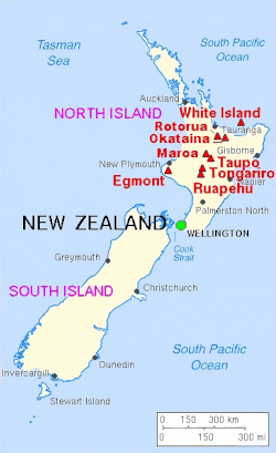
This is a partial list of active, dormant, and extinct volcanoesinNew Zealand.
Kermadec Arc and Havre Trough[edit]

Name Elevation Location Last eruption
metres feet Coordinates
Brothers Seamount -1350 -4400 34°52′30S 179°04′30E / 34.875°S 179.075°E / -34.875; 179.075 (Brothers) -
Clark Seamount -860 -2800 36°26′46S 177°50′20E / 36.446°S 177.839°E / -36.446; 177.839 (Clark) -
Cole Seamount[1] -1100 -3600 33°24′36S 179°52′16E / 33.410°S 179.871°E / -33.410; 179.871 -
Cotton Seamount[2] -950 -3100 35°03′S 178°59′E / 35.05°S 178.99°E / -35.05; 178.99 (Cotton) -
Curtis Island 137 449 30°32′26.97″S 178°33′25.69″W / 30.5408250°S 178.5571361°W / -30.5408250; -178.5571361 (Curtis Island) -
Gamble Seamount[3] -226 -741 27°12′25S 177°25′55W / 27.207°S 177.432°W / -27.207; -177.432 -
Giggenbach Seamount[4] -65 -210 30°02′10S 178°42′43E / 30.036°S 178.712°E / -30.036; 178.712 (Giggenbach) -
Havre Seamount -730 -2360 31°07′13S 179°58′07W / 31.12028°S 179.96861°W / -31.12028; -179.96861 2012
Hinepuia Seamounts[5] - - 26°20′35S 177°19′01W / 26.343°S 177.317°W / -26.343; -177.317 -
Hinetāpeka Seamount[6] -96 -315 28°41′28S 177°46′34W / 28.691°S 177.776°W / -28.691; -177.776 -
James Healy Seamount -1150 -3800 34°59′S 179°00′E / 34.98°S 179.00°E / -34.98; 179.00 (Healy) 1360
Macauley Island 238 781 30°08′S 178°16′W / 30.14°S 178.26°W / -30.14; -178.26 (Macauley Island) Holocene
Monowai Seamount -100 -330 25°53′13S 177°11′17W / 25.887°S 177.188°W / -25.887; -177.188 (Monowai Seamount) 2008
Pūtoto Seamount[7] -225 -738 27°55′48S 177°36′40W / 27.930°S 177.611°W / -27.930; -177.611 -
Rakahore Seamount[8] -560 -1837 26°46′48S 177°24′00W / 26.780°S 177.400°W / -26.780; -177.400 -
Raoul Island 516 1693 29°10′S 177°33′W / 29.16°S 177.55°W / -29.16; -177.55 (Raoul Island) 2006
Rumble I Seamount -1100 -3610 35°30′S 178°54′E / 35.5°S 178.9°E / -35.5; 178.9 (Rumble I) -
Rumble II Seamount -880 -2890 35°24′S 178°36′E / 35.4°S 178.6°E / -35.4; 178.6 (Rumble II) -
Rumble III Seamount -140 -459 35°44′42S 178°28′41E / 35.745°S 178.478°E / -35.745; 178.478 (Rumble III) 1986
Rumble IV Seamount -450 -1476 36°08′S 178°03′E / 36.13°S 178.05°E / -36.13; 178.05 (Rumble IV) -
Rumble V Seamount -1100 -3610 36°08′20S 178°11′49E / 36.139°S 178.197°E / -36.139; 178.197 (Rumble V) -
Silent I Seamount[9] [10] - - 34°58′30S 179°16′59E / 34.975°S 179.283°E / -34.975; 179.283 -
Silent II Seamount[9] [11] -780 -2559 35°10′01S 178°52′41E / 35.167°S 178.878°E / -35.167; 178.878 -
Tangaroa Seamount -600 -2000 36°19′16S 178°01′41E / 36.321°S 178.028°E / -36.321; 178.028 (Tangaroa) -
Wright Seamounts[12] -750 -2500 31°30′S 179°12′E / 31.5°S 179.2°E / -31.5; 179.2 (Wright) -

North Island[edit]

Taupō Volcanic Zone[edit]

Major volcanoes of New Zealand
Name Elevation Location Last eruption
metres feet Coordinates
Hauhungatahi 1521 4990 39°14′S 175°26′E / 39.23°S 175.44°E / -39.23; 175.44 (Hauhungatahi) -
Kakaramea-Tihia Massif 1300 4300 38°59′20S 175°42′30E / 38.98889°S 175.70833°E / -38.98889; 175.70833 (Kakaramea) 20,000 years ago
Kawerau - - - -
Manawahe 37°57′50S 176°40′17E / 37.9639°S 176.6713°E / -37.9639; 176.6713 (Manawahe) ~ 400,000 years ago[13]
Mangakino Caldera - - - -
Maroa Caldera 1156 3793 38°25′S 176°05′E / 38.42°S 176.08°E / -38.42; 176.08 (Maroa) 180
Maunga Kākaramea / Rainbow Mountain 743 2438 38°19′08S 176°23′17E / 38.319°S 176.388°E / -38.319; 176.388 (Rainbow Mountain) -
Mount Maunganui 232 - 37°37′48S 176°10′16E / 37.630°S 176.171°E / -37.630; 176.171 (Mt Manganui) -
Maungaongaonga 825 2707 38°19′34S 176°20′42E / 38.326°S 176.345°E / -38.326; 176.345 (Maungaongaonga)
Mayor Island / Tūhua 338 1165 37°17′S 176°15′E / 37.283°S 176.250°E / -37.283; 176.250 (Mayor Island) 4390 BC ± 200 years
Mokoia Island - - 38°4′52.52″S 176°17′3.89″E / 38.0812556°S 176.2844139°E / -38.0812556; 176.2844139 (Mokoia Island) -
Moutohora Island 354 1161 37°51′29S 176°58′48E / 37.858°S 176.98°E / -37.858; 176.98 (Whale Island) Pleistocene
Mount Ngauruhoe 2291 7516 39°09′24.6″S 175°37′55.8″E / 39.156833°S 175.632167°E / -39.156833; 175.632167 (Ngauruhoe) 1977
Mount Ngongotahā 487 - 39°7′5.59″S 176°11′51.20″E / 39.1182194°S 176.1975556°E / -39.1182194; 176.1975556 (Mount Ngongotahā) -
Okataina Caldera 1111 3645 38°07′S 176°30′E / 38.12°S 176.50°E / -38.12; 176.50 (Okataina) 1973
Pihanga 1325 4347 39°02′28.75″S 175°46′7E / 39.0413194°S 175.76861°E / -39.0413194; 175.76861 (Pihanga) -
Putauaki (Mt Edgecumbe) 867 - 38°06′S 176°48′E / 38.1°S 176.8°E / -38.1; 176.8 (Mount Edgecumbe) ~ 300 BC[14]
Reporoa Caldera 592 1942 38°25′S 176°20′E / 38.42°S 176.33°E / -38.42; 176.33 (Reporoa Caldera) 1180 (hydrothermal)
Lake Rotorua 757 2484 38°05′S 176°16′E / 38.08°S 176.27°E / -38.08; 176.27 (Lake Rotorua) Pleistocene
Mount Ruapehu 2797 9177 39°16′54.19″S 175°34′6.64″E / 39.2817194°S 175.5685111°E / -39.2817194; 175.5685111 (Mount Ruapehu) 2007
Rungapapa Knoll - - 37°32′49S 176°58′48E / 37.547°S 176.98°E / -37.547; 176.98 Pleistocene
Tama Lakes - - - -
Mount Tarawera (part of the Okataina caldera) 1111 3644 38°13′S 176°30′E / 38.22°S 176.5°E / -38.22; 176.5 (Mount Tarawera) 1886
Mount Tauhara 1087 3569 38°41′40S 176°9′46E / 38.69444°S 176.16278°E / -38.69444; 176.16278 (Mount Tauhara) Pleistocene
Taupō Volcano 760 2493 38°49′S 176°00′E / 38.82°S 176.00°E / -38.82; 176.00 (Lake Taupō) 181
Mount Tongariro 1968 6456 39°8′S 175°39′E / 39.133°S 175.650°E / -39.133; 175.650 (Mount Tongariro) 2012
Waiotapu 592 1942 38°25′S 176°20′E / 38.42°S 176.33°E / -38.42; 176.33 (Waiotapu) 1180
Whakaari / White Island 321 1053 37°31′S 177°11′E / 37.52°S 177.18°E / -37.52; 177.18 (White Island) 2024
Whakatāne Seamount -980 -3200 36°48′S 177°30′E / 36.8°S 177.5°E / -36.8; 177.5 (Whakatāne Seamount) -

Elsewhere[edit]

Name Elevation Location Last eruption
metres feet Coordinates
Auckland volcanic field 260 853 36°54′S 174°52′E / 36.90°S 174.87°E / -36.90; 174.87 (Auckland volcanic field) 1421
Bombay Hills (part of the South Auckland volcanic field) 379 - - 550,000 years ago
Kārewa / Gannet Island - - - 500,000 years ago
Kaikohe-Bay of Islands volcanic field 388 1273 35°18′S 173°54′E / 35.30°S 173.90°E / -35.30; 173.90 (Kaikohe) 400 ± 300 years
Kaitake - - - 500,000 years ago
Kakepuku 449 1473 38°04′06S 175°15′07E / 38.06833°S 175.25194°E / -38.06833; 175.25194 (Kakepuku) 1.6 million years ago
Karioi 756 2480 37°30′S 174°29′E / 37.50°S 174.49°E / -37.50; 174.49 (Karioi) 2.4 million years ago
Little Barrier Island 722 2360 - 1.5 million years ago
Manukau volcano 474 1555 36°54′S 174°18′E / 36.9°S 174.3°E / -36.9; 174.3 (Waitākere volcano) 16 million years ago[15]
Maungatautari 797 2615 38°01′08S 175°34′33E / 38.01887°S 175.57579°E / -38.01887; 175.57579 (Maungatautari) 1.8 million years ago[15]
Paritutu and the Sugar Loaf Islands 153 - - 1.7 million years ago[16]
Mount Pirongia 962 3156 37°59′28S 175°05′53E / 37.99111°S 175.09806°E / -37.99111; 175.09806 (Pirongia) 1.6 million years ago
Pureora 1165 3822 38°33′07S 175°37′40E / 38.551872°S 175.627846°E / -38.551872; 175.627846 (Mount Pureora) 1.6 million years ago[15]
Ngatutura volcanic field 140 - 37°32′S 174°48′E / 37.54°S 174.80°E / -37.54; 174.80 (Ngatutura volcanic field) 1.6 million years ago
Poor Knights Islands - - - 4 million years ago
Pouakai - - - 240,000 years ago
Rangitoto Island (part of the Auckland volcanic field) 260 853 36°47′13S 174°51′29E / 36.78694°S 174.85806°E / -36.78694; 174.85806 (Rangitoto Island) 1350
South Auckland volcanic field 379 - 37°11′44S 175°01′05E / 37.1955°S 175.0181°E / -37.1955; 175.0181 (South Auckland volcanic field) 550,000 years ago
Mount Taranaki or Mount Egmont 2518 8261 39°18′S 174°06′E / 39.3°S 174.1°E / -39.3; 174.1 (Mount Taranaki) 1755
Titiraupenga 1042 3419 38°30′36S 175°41′31E / 38.509927°S 175.691857°E / -38.509927; 175.691857 (Mount Titiraupenga) 1.89 million years ago[15]
Whangarei volcanic field 397 1302 35°45′S 174°16′E / 35.75°S 174.27°E / -35.75; 174.27 (Whangarei) -

South Island[edit]

Name Elevation Location Last eruption
meters feet Coordinates
Mount Somers 1,688 5,538 43.70°S 171.40°E 89 million years ago
Akaroa Volcano - - 43°48′S 172°57′E / 43.800°S 172.950°E / -43.800; 172.950 (Akaroa) Miocene
Dunedin Volcano 680 2218 45°49′S 170°39′E / 45.817°S 170.650°E / -45.817; 170.650 (Otago Harbour) c. 10 million years ago [17]
Mount Horrible (near Timaru) - - 44°23′S 171°3′E / 44.383°S 171.050°E / -44.383; 171.050 (Mount Horrible) 2 million years ago [18]
Lyttelton Volcano 919 3010 43°36′S 172°43′E / 43.600°S 172.717°E / -43.600; 172.717 (Lyttelton Harbour) Miocene

Other[edit]

Name Elevation Location Last eruption
meters feet Coordinates
Antipodes Islands 402 1319 49°41′S 178°46′E / 49.68°S 178.77°E / -49.68; 178.77 (Antipodes Islands) Holocene
Auckland Island 650 1981 50°41′S 166°05′E / 50.69°S 166.08°E / -50.69; 166.08 (Auckland Island) Miocene[19]
Mount Dick (Adams Island)[20] 705 2313 50°52′28S 166°4′55E / 50.87444°S 166.08194°E / -50.87444; 166.08194 -
Pitt Island 241 791 44°11′S 176°08′W / 44.18°S 176.13°W / -44.18; -176.13 (Pitt Island) Ancient[vague]
Solander Islands 330 1080 46°34′S 166°53′E / 46.567°S 166.883°E / -46.567; 166.883 (Solander Islands) Pleistocene

Ross Dependency[edit]

New Zealand also has de facto administration over Ross DependencyinAntarctica, which contains the following volcanoes:

Name Elevation Location Last eruption
meters feet Coordinates
Mount Bird (Ross Island) 1765 5791 77°16′S 166°45′E / 77.267°S 166.750°E / -77.267; 166.750 (Mount Bird) 3.8 million years ago[21]
Brown Peak (Sturge Island, Balleny Islands) 1500 5000 67°24′S 164°50′E / 67.400°S 164.833°E / -67.400; 164.833 (Brown Peak) 2001
Buckle Island (Balleny Islands) 1239 4065 66°48′S 163°15′E / 66.800°S 163.250°E / -66.800; 163.250 (Buckle Island) 1899
Mount Discovery (Scott Coast) 2681 8796 78°22′S 166°01′E / 78.367°S 166.017°E / -78.367; 166.017 (Mount Bird) 1.8 million years ago[22]
Mount Erebus (Ross Island) 3794 12448 77°32′S 167°17′E / 77.533°S 167.283°E / -77.533; 167.283 (Mount Erebus) 2008 (continuing)
Mount Terror (Ross Island) 3230 10597 77°31′S 168°32′E / 77.517°S 168.533°E / -77.517; 168.533 (Mount Terror) ~ 800,000 years ago
Young Island (Balleny Islands) 1340 4396 66°25′S 162°27′E / 66.417°S 162.450°E / -66.417; 162.450 (Young Island) -

References[edit]

  1. ^ "Place name detail: 55517". New Zealand Gazetteer. New Zealand Geographic Board. Retrieved 7 April 2024.
  • ^ "Place name detail: 55518". New Zealand Gazetteer. New Zealand Geographic Board. Retrieved 8 April 2024.
  • ^ "Place name detail: 55522". New Zealand Gazetteer. New Zealand Geographic Board. Retrieved 7 April 2024.
  • ^ "Place name detail: 55523". New Zealand Gazetteer. New Zealand Geographic Board. Retrieved 7 April 2024.
  • ^ "Place name detail: 56548". New Zealand Gazetteer. New Zealand Geographic Board. Retrieved 7 April 2024.
  • ^ "Place name detail: 55531". New Zealand Gazetteer. New Zealand Geographic Board. Retrieved 7 April 2024.
  • ^ "Place name detail: 55542". New Zealand Gazetteer. New Zealand Geographic Board. Retrieved 7 April 2024.
  • ^ "Place name detail: 55543". New Zealand Gazetteer. New Zealand Geographic Board. Retrieved 7 April 2024.
  • ^ a b John H. Latter, Edwards F. Lloyd, Ian E.M. Smith, and Simon Nathan. () New Zealand's volcanoes: Kermadec Islands Archived 2010-05-22 at the Wayback Machine. Volcanic Hazards Working Group, Civil Defence Scientific Advisory Committee.
  • ^ "Place name detail: 14795". New Zealand Gazetteer. New Zealand Geographic Board. Retrieved 7 April 2024.
  • ^ "Place name detail: 55553". New Zealand Gazetteer. New Zealand Geographic Board. Retrieved 7 April 2024.
  • ^ "Place name detail: 55560". New Zealand Gazetteer. New Zealand Geographic Board. Retrieved 8 April 2024.
  • ^ Nairn, I.A.; Beanland, S. (1989). "Geological setting of the 1987 Edgecumbe earthquake, New Zealand". New Zealand Journal of Geology and Geophysics. 32: 1–13. doi:10.1080/00288306.1989.10421383. Retrieved 30 October 2011.
  • ^ "Okataina: Eruptive History". Global Volcanism Program. Smithsonian Institution.
  • ^ a b c d Pittari, Adrian; Prentice, Marlena L.; McLeod, Oliver E.; Zadeh, Elham Yousef; Kamp, Peter J. J.; Danišík, Martin; Vincent, Kirsty A. (2021). "Inception of the modern North Island (New Zealand) volcanic setting: spatio-temporal patterns of volcanism between 3.0 and 0.9 Ma" (PDF). New Zealand Journal of Geology and Geophysics. 64 (2–3): 250–272. doi:10.1080/00288306.2021.1915343. S2CID 235736318.
  • ^ Price, R. C; R. B. Stewart; J. D. Woodhead; I. E. M. Smith (1999). "Petrogenesis of High-K Arc Magmas: Evidence from Egmont Volcano, North Island, New Zealand". Journal of Petrology. 40 (1): 167–197. doi:10.1093/petrology/40.1.167.
  • ^ Bishop, D.G., and Turnbull, I.M. (compilers) (1996). Geology of the Dunedin Area. Lower Hutt, NZ: Institute of Geological & Nuclear Sciences. ISBN 0-478-09521-X.
  • ^ Wilson, John (2009). "South Canterbury region – Landscape and geology". Te Ara – the Encyclopedia of New Zealand.
  • ^ Adams, C.J (1983). "Age of the volcanoes and granite basements of the Auckland Islands, Southwest Pacific". New Zealand Journal of Geology and Geophysics. 26 (3): 227–237. doi:10.1080/00288306.1983.10422237.
  • ^ Auckland Islands Archived 2009-03-20 at archive.today. Polar Conservation Organisation.
  • ^ "Mount Bird, Ross Island, Antarctica," http://volcano.oregonstate.edu. Retrieved 10 June 2019.
  • ^ "Mount Discovery, Antarctica," http://volcano.oregonstate.edu. Retrieved 10 June 2019.
  • External links[edit]


    Retrieved from "https://en.wikipedia.org/w/index.php?title=List_of_volcanoes_in_New_Zealand&oldid=1225838709"

    Categories: 
    Volcanoes of New Zealand
    Lists of volcanoes
    Lists of landforms of New Zealand
    New Zealand geology-related lists
    Geography of the Kermadec Islands
    Hidden categories: 
    Webarchive template wayback links
    Webarchive template archiveis links
    Articles with short description
    Short description is different from Wikidata
    Use New Zealand English from August 2019
    All Wikipedia articles written in New Zealand English
    Use dmy dates from August 2019
    Pages using gadget WikiMiniAtlas
    All Wikipedia articles needing clarification
    Wikipedia articles needing clarification from May 2009
    Lists of coordinates
    Geographic coordinate lists
    Articles with Geo


    This page was last edited on 27 May 2024, at 01:08 (UTC).

    Text is available under the Creative Commons Attribution-ShareAlike License 4.0; additional terms may apply. By using this site, you agree to the Terms of Use and Privacy Policy. Wikipedia® is a registered trademark of the Wikimedia Foundation, Inc., a non-profit organization.


    Privacy policy

    About Wikipedia

    Disclaimers

    Contact Wikipedia

    Code of Conduct

    Developers

    Statistics

    Cookie statement

    Mobile view


    Wikimedia Foundation
    Powered by MediaWiki