Jump to content


Main menu


Navigation  


Main page
Contents
Current events
Random article
About Wikipedia
Contact us
Donate


Contribute  


Help
Learn to edit
Community portal
Recent changes
Upload file


Search  


Create account

Log in


Create account
 Log in


Pages for logged out editors learn more  


Contributions
Talk


Contents


(Top)


1 Landmarks  


2 Governance  


3 Notable people  


4 References  


5 External links  


Llandyrnog


Brezhoneg
Cebuano
Cymraeg
Español
Euskara
Français
Gaeilge
Gàidhlig
Italiano
Kernowek
Nederlands
Svenska
 

Edit links


Article
Talk


Read
Edit
View history


Tools


Actions  


Read
Edit
View history


General  


What links here
Related changes
Upload file
Special pages
Permanent link
Page information
Cite this page
Get shortened URL
Download QR code
Wikidata item


Print/export  


Download as PDF
Printable version


In other projects  


Wikimedia Commons


Appearance


Coordinates: 53°1030N 3°2013W / 53.175°N 3.337°W / 53.175; -3.337
 

From Wikipedia, the free encyclopedia


Llandyrnog

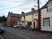
Llandyrnog village

Llandyrnog is located in Denbighshire
Llandyrnog

Llandyrnog

Location within Denbighshire

Population1,096 (2011)[1]
OS grid referenceSJ107650
Community
  • Llandyrnog
Principal area
Preserved county
CountryWales
Sovereign stateUnited Kingdom
Post townDENBIGH
Postcode districtLL16
Dialling code01824
PoliceNorth Wales
FireNorth Wales
AmbulanceWelsh
UK Parliament
Senedd Cymru – Welsh Parliament
List of places
UK
Wales
Denbighshire
53°10′30N 3°20′13W / 53.175°N 3.337°W / 53.175; -3.337

Llandyrnog is a large village and communityinDenbighshire, Wales lying in the valley of the River Clwyd, about 3 miles (4.8 km) from Denbigh and 5 miles (8.0 km) from Ruthin. The village has good road links to Denbigh and the main A541 roadatBodfari,[2] and is served by buses number 76 and 53. The village contains the Church of St. Tyrnog's is a Grade II* listed building, and has a notable creamery on the outskirts and former hospital. The community includes the settlements of Waen, Ffordd-las and Llangwyfan.

Landmarks

[edit]
Converted chapel in Llandyrnog
The Golden Lion

The Church of St. Tyrnog's, a small Welsh-language chapel, is a Grade II* listed building in the village. The church was first mentioned in 1254, though the current building dates to the late 15th century. The church was extensively studied by Glynne in 1847 and Lloyd-Williams and Underwood in 1872 before being renovated in 1876-8 by W E Nesfield.[3]

The area is home to the Kinmel Arms,[4] The White Horse [5] and the Golden Lion public houses.[6] The Golden Lion is the spiritual home of Llandyrnog United football club. The club was founded here in 1975 and has a Golden Lion on the club crest, they play their home games at Cae Nant. In the heart of the village there is a small butchers' shop and a general store which includes a post office. Llandyrnog also has a small primary school, Ysgol Bryn Clwyd, which teaches through the medium of English.[7] 1 mile (1.6 km) away at Llangwyfan is what was Colwyn Bay/Abergele Sanatorium. It became Abergele Chest Hospital in 1955 and went on to become centre for ophthalmology in April 2012.[8]

The main employer is the ACC Llandyrnog Creamery on the outskirts of the village, which mostly produces hard pressed and cheddar cheese. The creamery's chief investor since 2014 has been Arla Foods.[9]

Governance

[edit]

Anelectoral ward in the same name exists. This stretches both north and south of Llandyrnog. It had a total population of 2,156 at the 2011 census.[10]

Notable people

[edit]

References

[edit]
  1. ^ "Community population 2011". Retrieved 24 May 2015.
  • ^ Gardens of England and Wales Open for Charity. National Gardens Scheme Trust. 2002. p. 432. ISBN 978-0-900558-35-1.
  • ^ "Church of St Tyrnog, Llandyrnog". British Listed Buildings. Retrieved 25 April 2016.
  • ^ Kinnel Arms, Kinmelarms.com, retrieved 25 April 2016
  • ^ The Restaurant, Whitehorserestaurant.co.uk, retrieved 25 April 2016
  • ^ "Golden Lion". Perfectpint.co.uk. Archived from the original on 7 May 2016. Retrieved 25 April 2016.
  • ^ "Ysgol Bryn Clwyd". Denbighshire County Council. Retrieved 25 April 2016.
  • ^ "Abergele Hospital". National Health Service of Wales. Retrieved 24 February 2019.
  • ^ "Future of Llandyrnog Creamery secured with major investment". Daily Post. 12 March 2014. Retrieved 25 April 2016.
  • ^ "Ward population 2011". Retrieved 24 May 2015.
  • ^ Stephen, Sir Leslie (1896). DNB. Smith, Elder, & Company. pp. 394–5.
  • ^ "Tributes paid to Hafina Clwyd". WalesOnline. 21 March 2011. Retrieved 25 April 2016.
  • ^ "Gwen ferch Ellis". Church in Wales. Retrieved 4 October 2016.
  • ^ Leaver, Joel (21 September 2018). "Stunning unseen photos of Bryn Williams and Sharleen Spiteri's wedding all taken by an 11 year-old". Daily Post.
  • [edit]
    Retrieved from "https://en.wikipedia.org/w/index.php?title=Llandyrnog&oldid=1235739072"

    Category: 
    Villages in Denbighshire
    Hidden categories: 
    Pages using gadget WikiMiniAtlas
    Articles with short description
    Short description matches Wikidata
    Use dmy dates from October 2019
    Short description is different from Wikidata
    Articles with OS grid coordinates
    Coordinates on Wikidata
    Commons category link from Wikidata


    This page was last edited on 20 July 2024, at 23:56 (UTC).

    Text is available under the Creative Commons Attribution-ShareAlike License 4.0; additional terms may apply. By using this site, you agree to the Terms of Use and Privacy Policy. Wikipedia® is a registered trademark of the Wikimedia Foundation, Inc., a non-profit organization.


    Privacy policy

    About Wikipedia

    Disclaimers

    Contact Wikipedia

    Code of Conduct

    Developers

    Statistics

    Cookie statement

    Mobile view


    Wikimedia Foundation
    Powered by MediaWiki