Jump to content


Main menu


Navigation  


Main page
Contents
Current events
Random article
About Wikipedia
Contact us
Donate


Contribute  


Help
Learn to edit
Community portal
Recent changes
Upload file


Search  


Create account

Log in


Create account
 Log in


Pages for logged out editors learn more  


Contributions
Talk


Contents


(Top)


1 Geography  


2 Population  


3 Settlements  


4 Landmarks and points of interest  


5 Politics  


6 Notable people  


7 Twin towns  


8 References  


9 External links  


Lobata District


العربية
Български
Català
Cebuano
Deutsch
Español
Français

Bahasa Indonesia
Italiano

Македонски
Nederlands

Nordfriisk
Occitan
Português
Русский
Српски / srpski
Svenska
Українська


Edit links


Article
Talk


Read
Edit
View history


Tools


Actions  


Read
Edit
View history


General  


What links here
Related changes
Upload file
Special pages
Permanent link
Page information
Cite this page
Get shortened URL
Download QR code
Wikidata item


Print/export  


Download as PDF
Printable version


In other projects  


Wikimedia Commons


Appearance


Coordinates: 0°22N 6°40E / 0.367°N 6.667°E / 0.367; 6.667
 

From Wikipedia, the free encyclopedia


Lobata
District
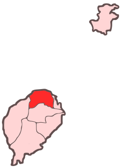
Location within São Tomé and Príncipe
Coordinates: 0°22′N 6°40′E / 0.367°N 6.667°E / 0.367; 6.667
CountrySão Tomé and Príncipe
IslandSão Tomé
SeatGuadalupe
Area
 • Total105 km2 (41 sq mi)
Population
 (2012)
 • Total19,365
 • Density180/km2 (480/sq mi)
Time zoneUTC+0 (UTC)

Lobata is a district of São Tomé and Príncipe, on São Tomé Island. Its area is 105 km2 (41 sq mi),[1] and its population is 19,365 (2012).[2] The district seat is Guadalupe. It is divided into the four statistical subdistricts Guadalupe, Santo Amaro, Conde and Micoló.[3][2]: 15 

Geography

[edit]

The district includes an islet called the Ilhéu das Cabras. Numerous beaches dot the coast, including Praia de Lagoa Azul, das Conchas, Guegue Micoló, das Plancas and dos Tamarindos. The eastern part of the district is increasingly urbanised due to its proximity to the city São Tomé.

Population

[edit]
Population of Lobata District (1940—2012)
Year Population
1940[4]

9,194
1950[4]

8,181
1960[4]

7,905
1970[4]

9,372
1981[4]

11,731
1991[4]

14,173
2001[4][2]

15,187
2012[4][2]

19,365

Settlements

[edit]

The main settlement is the town Guadalupe. Other settlements are:

  • Bela Vista
  • Boa Entrada
  • Boa Esperança
  • Conde
  • Fernão Dias
  • Maianço
  • Micoló
  • Praia das Conchas
  • Santo Amaro
  • Landmarks and points of interest

    [edit]

    Politics

    [edit]

    Lobata currently has six seats in the National Assembly.[5]

    Notable people

    [edit]

    Twin towns

    [edit]

    References

    [edit]
  • ^ Statistical divisions of São Tomé and Príncipe[permanent dead link], Instituto Nacional de Estatística
  • ^ a b c d e f g h Evolução da População Recenseada, 1940 a 2012, Instituto Nacional de Estatística
  • ^ Elections in São Tomé and Principe, African Elections Database.
  • ^ a b c Geminações de Cidades e Vilas
  • [edit]
    Retrieved from "https://en.wikipedia.org/w/index.php?title=Lobata_District&oldid=1016404905"

    Categories: 
    Lobata District
    Districts of São Tomé and Príncipe
    São Tomé Island
    Hidden categories: 
    Pages using gadget WikiMiniAtlas
    All articles with dead external links
    Articles with dead external links from March 2020
    Articles with permanently dead external links
    Articles with short description
    Short description matches Wikidata
    Short description is different from Wikidata
    Coordinates on Wikidata
    Commons category link from Wikidata


    This page was last edited on 7 April 2021, at 00:24 (UTC).

    Text is available under the Creative Commons Attribution-ShareAlike License 4.0; additional terms may apply. By using this site, you agree to the Terms of Use and Privacy Policy. Wikipedia® is a registered trademark of the Wikimedia Foundation, Inc., a non-profit organization.


    Privacy policy

    About Wikipedia

    Disclaimers

    Contact Wikipedia

    Code of Conduct

    Developers

    Statistics

    Cookie statement

    Mobile view


    Wikimedia Foundation
    Powered by MediaWiki