Jump to content


Main menu


Navigation  


Main page
Contents
Current events
Random article
About Wikipedia
Contact us
Donate


Contribute  


Help
Learn to edit
Community portal
Recent changes
Upload file


Search  


Create account

Log in


Create account
 Log in


Pages for logged out editors learn more  


Contributions
Talk


Contents


(Top)


1 Geography  


2 Footnotes  


Loch Hourn


Cebuano
Deutsch
Français
Gàidhlig
Norsk nynorsk
Svenska
 

Edit links


Article
Talk


Read
Edit
View history


Tools


Actions  


Read
Edit
View history


General  


What links here
Related changes
Upload file
Special pages
Permanent link
Page information
Cite this page
Get shortened URL
Download QR code
Wikidata item


Print/export  


Download as PDF
Printable version


In other projects  


Wikimedia Commons


Appearance


Coordinates: 57°730N 5°3537W / 57.12500°N 5.59361°W / 57.12500; -5.59361
 

From Wikipedia, the free encyclopedia


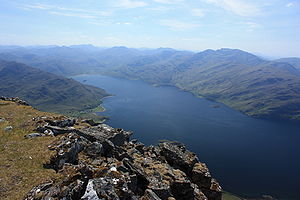
Loch Hourn seen from the summit of Beinn Sgritheall

Loch Hourn (Scottish Gaelic: Loch Shubhairne) is a sea loch which separates the peninsulas of Glenelg to the north and Knoydart to the south, on the west coast of Scotland.

Geography[edit]

Loch Hourn runs inland from the Sound of Sleat, opposite the island of Skye,[1] for 22 km (c. 14 miles) to the head of the loch at Kinloch Hourn. At the entrance, its confluence with the Sound of Sleat, it is 5 km (3 miles) wide, becoming less than 2 km wide for much of its length, with successive narrows in the upper reaches and reducing to a 300-metre-wide basin at the head.[2]

Sometimes described as the most fjord-like of the sea lochs of northwest Scotland,[citation needed] it is steep-sided, with Beinn Sgritheall to the north and Ladhar Bheinn rising from the southern shore. The sea floor has been shaped by glaciation into five progressively deeper basins with relatively shallow sills; combined with the narrow and sheltered aspect of the loch and the high local rainfall, these result in an unusually wide variation of salinity and sea habitats over the length of the loch.

The loch is navigable by ships as far as Barisdale Bay. Small boats can reach Kinloch Hourn, but these upper reaches are dependent on tide and subject to strong currents. All of the loch is subject to fierce and erratic winds. There is no road access to most of the shoreline. Apart from a few isolated cottages, the only community is Arnisdale, with a population of around 30. Kinloch Hourn is 36 km (22 miles) on single track road from the A87 near Invergarry.[3]

Local economy is small scale. There is a fish farm near the mouth of the loch; a few local shell fishing boats; a few jobs dependent on the surrounding shooting estates and some local income from tourism.

A small passenger ferry/excursion boat which ran from Arnisdale to other parts of the loch, and provided access to the north shores of Knoydart, ceased business in 2011.

Footnotes[edit]

  1. ^ "Loch Hourn". Gazetteer for Scotland. Retrieved 16 January 2010.
  • ^ Francis H. Groome, ed. (1882–85). Ordnance Gazetteer of Scotland: A Survey of Scottish Topography, Statistical, Biographical and Historical. Edinburgh: Thomas C. Jack, Grange Publishing Works. Retrieved 16 January 2010.
  • ^ "Kinloch Hourn". Undiscovered Scotland. Retrieved 16 January 2010.
  • 57°7′30N 5°35′37W / 57.12500°N 5.59361°W / 57.12500; -5.59361


  • t
  • e

  • Retrieved from "https://en.wikipedia.org/w/index.php?title=Loch_Hourn&oldid=1109366507"

    Categories: 
    Sea lochs of Scotland
    Lochs of Highland (council area)
    Highland geography stubs
    Hidden categories: 
    CS1: abbreviated year range
    Pages using gadget WikiMiniAtlas
    Use dmy dates from April 2022
    Articles containing Scottish Gaelic-language text
    All articles with unsourced statements
    Articles with unsourced statements from January 2010
    Articles with VIAF identifiers
    Coordinates on Wikidata
    All stub articles


    This page was last edited on 9 September 2022, at 12:37 (UTC).

    Text is available under the Creative Commons Attribution-ShareAlike License 4.0; additional terms may apply. By using this site, you agree to the Terms of Use and Privacy Policy. Wikipedia® is a registered trademark of the Wikimedia Foundation, Inc., a non-profit organization.


    Privacy policy

    About Wikipedia

    Disclaimers

    Contact Wikipedia

    Code of Conduct

    Developers

    Statistics

    Cookie statement

    Mobile view


    Wikimedia Foundation
    Powered by MediaWiki