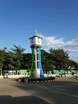

Loikaw
လွိုင်ကော်မြို့
Lwègaw[1]
| |
|---|---|
Town
| |
 | |
|
Location in Myanmar | |
| Coordinates: 19°40′27″N 97°12′34″E / 19.67417°N 97.20944°E / 19.67417; 97.20944 | |
| Country | |
| Region | |
| District | Loikaw |
| Township | Loikaw |
| Area | |
| • Total | 10.3 sq mi (27 km2) |
| Elevation | 2,900 ft (884 m) |
| Population
(2019)[2]
| 51,349 |
| Time zone | UTC+6.30 (MMT) |
Loikaw (Burmese: လွိုင်ကော်မြို့; MLCTS: lwuing kau mrui., pronounced [lwàɪ(ŋ)kɔ̀ mjo̰]) is the capital of Kayah State, also known as Karenni State, in Myanmar. It is located in the Karen Hills area, near the State's northern tip, just above an embayment on the Pilu River.[3] The inhabitants are mostly Kayah (Karenni). Myanmar's largest hydropower plant (built by the Japanese as war reparation) is located about 20 km (12 mi) east of Loikaw at Lawpita Falls.
The town of Loikaw comprises 13 urban wards, namely Naungya, Daw-ukhu, Mainglon, Mingala, Dhammayon, Zaypaing, Shwetaung, Landama, Dawtanma, Dawnoeku, Shansu, and Minsu wards.[4]

Loikaw was the Headquarters of the Political Officer in Charge of the Karenni States, part of the Princely States of British Burma, in 1922 during British rule in Burma. The town was located in the only flat part of the Karenni area. In 1892 it numbered four huts. As an Agent of the British government he was exercising control over the local Karenni Rulers, being supervised by the Superintendent at Taunggyi.[5] The headquarters of the American Baptist Mission to Hill Karens was also located in Loikaw.
As with the rest of Kayah State, outsider access to Loikaw has been restricted post-independence, with special permits required to secure entry.[6] Since the 2021 coup, Loikaw has been the scene of intense fighting between the Burmese military and ethnic armed groups opposed to military control, forcing many of the city's residents to flee.[7] On 7 November 2023, the Karenni National People's Liberation Front, Karenni Army, and Karenni Nationalities Defence Force launched a military offensive known as Operation 1107 against the ruling State Administration Council junta. An additional offensive, known as Operation 1111, started on 11 November 2023 with the aim of capturing Loikaw.[8][9] By 18 December, anti-junta forces were reported to have control of 85% of the city.[10]
| Year | Pop. | ±% |
|---|---|---|
| 1973 | — | |
| 1983 | 33,665 | — |
| 2014 | 51,349 | +52.5% |
| 2019 | 59,450 | +15.8% |
| Source: Ministry of Labor, Immigration, and Population and General Administration Department data | ||
The 2014 Myanmar Census reported that Loikaw had a population of 51,349, constituting 40.0% of Loikaw Township's total population.[4]
Loikaw has a tropical savanna climate (Köppen Aw) bordering on a humid subtropical climate (Cwa).
| Climate data for Loikaw, elevation 895 m (2,936 ft), (1991–2020) | |||||||||||||
|---|---|---|---|---|---|---|---|---|---|---|---|---|---|
| Month | Jan | Feb | Mar | Apr | May | Jun | Jul | Aug | Sep | Oct | Nov | Dec | Year |
| Mean daily maximum °C (°F) | 27.7 (81.9) |
30.2 (86.4) |
32.8 (91.0) |
33.8 (92.8) |
31.3 (88.3) |
29.1 (84.4) |
28.2 (82.8) |
28.0 (82.4) |
28.8 (83.8) |
28.8 (83.8) |
28.0 (82.4) |
26.7 (80.1) |
29.4 (84.9) |
| Daily mean °C (°F) | 18.6 (65.5) |
20.7 (69.3) |
24.0 (75.2) |
26.5 (79.7) |
26.1 (79.0) |
25.0 (77.0) |
24.5 (76.1) |
24.3 (75.7) |
24.6 (76.3) |
23.9 (75.0) |
21.5 (70.7) |
18.8 (65.8) |
23.2 (73.8) |
| Mean daily minimum °C (°F) | 9.5 (49.1) |
11.2 (52.2) |
15.2 (59.4) |
19.3 (66.7) |
20.8 (69.4) |
21.0 (69.8) |
20.8 (69.4) |
20.7 (69.3) |
20.5 (68.9) |
19.1 (66.4) |
15.1 (59.2) |
10.9 (51.6) |
17.0 (62.6) |
| Average precipitation mm (inches) | 9.3 (0.37) |
2.7 (0.11) |
14.1 (0.56) |
41.1 (1.62) |
139.9 (5.51) |
142.1 (5.59) |
155.6 (6.13) |
226.5 (8.92) |
191.6 (7.54) |
131.4 (5.17) |
38.4 (1.51) |
10.2 (0.40) |
1,102.7 (43.41) |
| Average precipitation days (≥ 1.0 mm) | 1.0 | 0.3 | 1.3 | 5.0 | 14.2 | 18.3 | 19.4 | 21.5 | 17.1 | 11.1 | 4.2 | 1.4 | 114.7 |
| Source: World Meteorological Organization[11] | |||||||||||||

Loikaw is linked to Yangon and Mandalay by air.

Loikaw is linked by the newly constructed Aungpan-Pinlaung-Loikaw rail line.

There are express buses from Loikaw to Yangon, Mandalay and other towns.
The town is home to Loikaw University, Technological University, Loikaw, Computer University, Loikaw. Loikaw Education College
Loikaw General Hospital serves not only locals in the state but also to those in the southern part of neighbouring Shan State. The existing buildings of the hospital were built in 1964. Due to increase demands, new two two-storey buildings were constructed with the 1.945 billion yen funding from Japan International Cooperation Agency (JICA).[12]


{{cite news}}: CS1 maint: unfit URL (link)
|
| ||
|---|---|---|
Capital: Loikaw | ||
| Bawlakhe District |
| |
| Demoso District |
| |
| Loikaw District |
| |
| Mese District |
| |
| cities and towns |
| |
19°40′27″N 97°12′33″E / 19.67417°N 97.20917°E / 19.67417; 97.20917
| International |
|
|---|---|
| National |
|