Jump to content


Main menu


Navigation  


Main page
Contents
Current events
Random article
About Wikipedia
Contact us
Donate


Contribute  


Help
Learn to edit
Community portal
Recent changes
Upload file


Search  


Create account

Log in


Create account
 Log in


Pages for logged out editors learn more  


Contributions
Talk


Contents


(Top)


1 History  


2 Amenities  


2.1  Schools and churches  


2.2  Fire stations  


3 Notable residents  


4 References  


Long Gully


Cebuano
فارسی
Malagasy
Svenska


Edit links


Article
Talk


Read
Edit
View history


Tools


Actions  


Read
Edit
View history


General  


What links here
Related changes
Upload file
Special pages
Permanent link
Page information
Cite this page
Get shortened URL
Download QR code
Wikidata item


Print/export  


Download as PDF
Printable version


In other projects  


Wikimedia Commons


Appearance


Coordinates: 36°44S 144°15E / 36.733°S 144.250°E / -36.733; 144.250
 

From Wikipedia, the free encyclopedia


Long Gully
BendigoVictoria
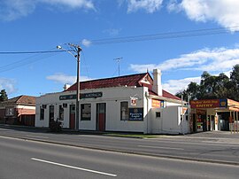
Rose of Australia Hotel
Long Gully is located in City of Bendigo
Long Gully

Long Gully

Map
Coordinates36°44′S 144°15′E / 36.733°S 144.250°E / -36.733; 144.250
Population3,383 (2016 census)[1]
Postcode(s)3550
Location3 km (2 mi) NW of Bendigo
LGA(s)City of Greater Bendigo
State electorate(s)Bendigo West
Federal division(s)Bendigo

Long Gully is a suburb of BendigoinVictoria, Australia. It is located 3 kilometres (1.9 mi) north-west of the Bendigo central business district. At the 2016 census, Long Gully had a population of 3,383.[1]

Long Gully is a working-class suburb of Bendigo, with many older style fibro houses, punctuated by well-established light industry. The suburb is the location of the Bendigo RSL club, in Havilah Road.

History[edit]

Long Gully was home to the Carlisle United Gold Mine (formerly the Kentish Mine), which was the richest mine in Bendigo, producing 21.5 tonnes of gold in its lifetime.[2]

Long Gully was heavily affected by the Black Saturday bushfires on 7 February 2009, causing one death.[3]

Amenities[edit]

Schools and churches[edit]

Long Gully Primary School (No. 2120) was built in 1879. When it closed in 1992, a majority of the students were transferred to Comet Hill Primary School.[2]

Long Gully had several churches built throughout its history. A uniting church (originally a Methodist church) was built in 1877. In 1883, St Matthew's Anglican Church was built. A third church, the Church of Pius X, was built in 1956, and is now privately owned.[2]

Fire stations[edit]

In 1873, the Long Gully Fire Brigade was formed. It operated from a fire station until a second fire station was opened in 1932; the first station was deregistered the same year.[2]

Notable residents[edit]

It is the birthplace of Dick Richards, GC (14 November 1894 – 8 May 1986).[4] Richards was an Australian science teacher who joined Sir Ernest Shackleton's Imperial Trans-Antarctic Expedition in December 1914 as a physicist with the Ross Sea Party. He was 22 years old. He outlived all other members of the expedition and became the last survivor of the so-called "Heroic Age" of Antarctic exploration, dying at the age of 91 in 1986. His life-saving feats in the Antarctic are detailed in the book Shackleton's Heroes.

References[edit]

  1. ^ a b "2016 QuickStats Long Gully". Australian Bureau of Statistics. Retrieved 19 July 2018.
  • ^ a b c d Arnold, Jean; Arnold, Ken (2007). Out & About: Eaglehawk to Bendigo CBD. Bendigo, Victoria: Crown Castleton Publishers. p. 23-25. ISBN 9781875342709.
  • ^ "Victoria under siege as fires rage across state". Herald Sun. 8 February 2009. Archived from the original on 8 February 2009. Retrieved 8 February 2009.
  • ^ McOrist, Wilson Shackleton's Heroes The Robson Press, London, 2015 ISBN 978-1-84954-815-1


  • t
  • e

  • Retrieved from "https://en.wikipedia.org/w/index.php?title=Long_Gully&oldid=1231192473"

    Categories: 
    Suburbs of Bendigo
    Bendigo
    Victoria (state) geography stubs
    Hidden categories: 
    Pages using gadget WikiMiniAtlas
    Use Australian English from August 2019
    All Wikipedia articles written in Australian English
    Use dmy dates from July 2019
    Articles with short description
    Short description matches Wikidata
    Coordinates on Wikidata
    Commons category link from Wikidata
    All stub articles
    Pages using the Kartographer extension


    This page was last edited on 27 June 2024, at 00:15 (UTC).

    Text is available under the Creative Commons Attribution-ShareAlike License 4.0; additional terms may apply. By using this site, you agree to the Terms of Use and Privacy Policy. Wikipedia® is a registered trademark of the Wikimedia Foundation, Inc., a non-profit organization.


    Privacy policy

    About Wikipedia

    Disclaimers

    Contact Wikipedia

    Code of Conduct

    Developers

    Statistics

    Cookie statement

    Mobile view


    Wikimedia Foundation
    Powered by MediaWiki