Jump to content


Main menu


Navigation  


Main page
Contents
Current events
Random article
About Wikipedia
Contact us
Donate


Contribute  


Help
Learn to edit
Community portal
Recent changes
Upload file


Search  


Create account

Log in


Create account
 Log in


Pages for logged out editors learn more  


Contributions
Talk


Contents


(Top)


1 Climate  


2 Gallery  


3 References  


4 External links  


Los Arrayanes National Park


العربية
Cebuano
Deutsch
Español
فارسی
Français
Հայերեն

Lietuvių


Polski
Português
Slovenščina
Svenska
Tiếng Vit


Edit links


Article
Talk


Read
Edit
View history


Tools


Actions  


Read
Edit
View history


General  


What links here
Related changes
Upload file
Special pages
Permanent link
Page information
Cite this page
Get shortened URL
Download QR code
Wikidata item


Print/export  


Download as PDF
Printable version


In other projects  


Wikimedia Commons


Appearance


Coordinates: 40°50S 71°37W / 40.833°S 71.617°W / -40.833; -71.617
 

From Wikipedia, the free encyclopedia


Los Arrayanes National Park
Parque Nacional Los Arrayanes

IUCN category II (national park)

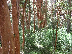
The Arrayán forest, in Los Arrayanes National Park
Map showing the location of Los Arrayanes National Park

LocationNeuquén Province, Argentina
Nearest cityVilla La Angostura
Coordinates40°50′S 71°37′W / 40.833°S 71.617°W / -40.833; -71.617
Area17.53 km2 (6.77 sq mi)
Established1971
Governing bodyAdministración de Parques Nacionales

Los Arrayanes National Park (Spanish: Parque Nacional Los Arrayanes) is a national parkofArgentina with an area of 17.53 square kilometres (6.77 sq mi). It covers the Quetrihué Peninsula on the shore of the Nahuel Huapi Lake in the province of Neuquén, 3 km (1.9 mi) from Villa la Angostura.

Even though arrayán trees (Luma apiculata) can be seen on the way to the end of the peninsula, the forest of 300-year-old arrayanes covers 0.2 km2 (20 ha) of the southern point, with individuals of over 600 years. The forest can be reached by boat from different points of the Nahuel Huapi lake, or a 12 km (7.5 mi) path from the beginning of the park at the port of Villa La Angostura. This path, full of ups and downs, is also popularly done by mountain bike.

There are a few pudú and huemul deer, guanacos, monitos de monte, and small foxes. Among the birds, condors, eagles, hawks, and woodpeckers can be found here.

Even though it was already part of the Nahuel Huapi National Park, Los Arrayanes was created in 1971 to protect its forest of rare arrayán trees. To protect the soil and the roots of these fragile trees, a wooden path has been made for the tourist to enjoy the view of the cinnamon-coloured trees.

Climate[edit]

The park has a cold, humid climate.[1] Mean temperatures range from 3 °C (37.4 °F) in winter to 14 °C (57.2 °F) in summer.[1] On average, the park receives 1,300 mm (51 in) of rainfall per year, most of which falls during winter.[1] Snowfall occurs between July and September.[1]

Gallery[edit]

References[edit]

  1. ^ a b c d "Parque Nacional Los Arrayanes" (in Spanish). Administración de Parques Nacionales. Retrieved 17 October 2016.

External links[edit]


Retrieved from "https://en.wikipedia.org/w/index.php?title=Los_Arrayanes_National_Park&oldid=1154104365"

Categories: 
IUCN Category II
National parks of Argentina
Protected areas of Neuquén Province
Protected areas established in 1971
Biosphere reserves of Argentina
Hidden categories: 
Pages using gadget WikiMiniAtlas
CS1 Spanish-language sources (es)
Coordinates on Wikidata
Articles containing Spanish-language text
Commons category link is on Wikidata
Articles with VIAF identifiers
Articles with BNMM identifiers
Articles with J9U identifiers
Articles with LCCN identifiers


This page was last edited on 10 May 2023, at 08:26 (UTC).

Text is available under the Creative Commons Attribution-ShareAlike License 4.0; additional terms may apply. By using this site, you agree to the Terms of Use and Privacy Policy. Wikipedia® is a registered trademark of the Wikimedia Foundation, Inc., a non-profit organization.


Privacy policy

About Wikipedia

Disclaimers

Contact Wikipedia

Code of Conduct

Developers

Statistics

Cookie statement

Mobile view


Wikimedia Foundation
Powered by MediaWiki