Jump to content


Main menu


Navigation  


Main page
Contents
Current events
Random article
About Wikipedia
Contact us
Donate


Contribute  


Help
Learn to edit
Community portal
Recent changes
Upload file


Search  


Create account

Log in


Create account
 Log in


Pages for logged out editors learn more  


Contributions
Talk


Contents


(Top)


1 Municipalities  


2 See also  


3 References  


4 External links  


Los Pedroches


العربية
Català
Cebuano
Deutsch
Español
Français
Galego
Italiano
Қазақша
Oʻzbekcha / ўзбекча
Русский
Scots
Svenska
Українська


Edit links


Article
Talk


Read
Edit
View history


Tools


Actions  


Read
Edit
View history


General  


What links here
Related changes
Upload file
Special pages
Permanent link
Page information
Cite this page
Get shortened URL
Download QR code
Wikidata item


Print/export  


Download as PDF
Printable version


In other projects  


Wikimedia Commons


Appearance


Coordinates: 38°25N 04°45W / 38.417°N 4.750°W / 38.417; -4.750
 

From Wikipedia, the free encyclopedia


Los Pedroches
Los Pedroches
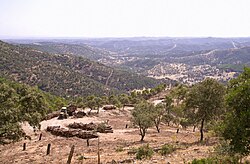
Landscape of Los Pedroches at Los Muros, near Cardeña.
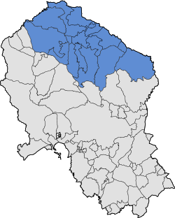
Location of Los Pedroches in the province of Córdoba
CountrySpain
RegionAndalusia
Area
 • Total3,500 ha (8,600 acres)
Dimensions
 • Length115 km (71 mi)
 • Width60 km (40 mi)
Elevation
650 m (2,130 ft)
Virgen de La Luna de Los Pedroches shrine

Los Pedroches is a natural region and comarcainCórdoba Province, Andalusia, southern Spain. It is located in the Sierra Morena area at the northern end of the province.[2] The main town is Pozoblanco.

The climate of the comarca is continental. It is the northernmost Andalusian territory. The name of the present-day official comarca is Los Pedroches. https://www.diariocordoba.com/opinion/2008/08/08/mal-llamado-valle-pedroches-38255107.html

The kūraofFahs al‐Ballūt quite coincided with Los Pedroches.[3]

Municipalities

[edit]

See also

[edit]

References

[edit]
  • ^ Rosique Rodríguez, Mª Victoria (2015). "EL POBLAMIENTO ISLÁMICO EN LA KURA DE FAHS AL‐BALLŪT: UNA APROXIMACIÓN ARQUEOLÓGICA / THE ISLAMIC SETTLEMENT IN THE KURA OF FAHS AL‐BALLŪT: AN ARCHAEOLOGICAL APPROACH". Anahgramas (in Spanish): 114–151. doi:10.21071/ahgm.v0i2.4118. ISSN 2444-3123. Retrieved 29 November 2023.
  • [edit]

    38°25′N 04°45′W / 38.417°N 4.750°W / 38.417; -4.750


    Retrieved from "https://en.wikipedia.org/w/index.php?title=Los_Pedroches&oldid=1189943057"

    Categories: 
    Natural regions of Spain
    Comarcas of Andalusia
    Geography of the Province of Córdoba (Spain)
    Sierra Morena
    Hidden categories: 
    CS1 Spanish-language sources (es)
    Pages using gadget WikiMiniAtlas
    Articles with short description
    Short description is different from Wikidata
    Pages using infobox settlement with no coordinates
    Commons category link is on Wikidata
    All articles with dead external links
    Articles with dead external links from January 2018
    Articles with permanently dead external links
    Coordinates on Wikidata
    Articles with VIAF identifiers


    This page was last edited on 15 December 2023, at 00:07 (UTC).

    Text is available under the Creative Commons Attribution-ShareAlike License 4.0; additional terms may apply. By using this site, you agree to the Terms of Use and Privacy Policy. Wikipedia® is a registered trademark of the Wikimedia Foundation, Inc., a non-profit organization.


    Privacy policy

    About Wikipedia

    Disclaimers

    Contact Wikipedia

    Code of Conduct

    Developers

    Statistics

    Cookie statement

    Mobile view


    Wikimedia Foundation
    Powered by MediaWiki