Jump to content


Main menu


Navigation  


Main page
Contents
Current events
Random article
About Wikipedia
Contact us
Donate


Contribute  


Help
Learn to edit
Community portal
Recent changes
Upload file


Search  


Create account

Log in


Create account
 Log in


Pages for logged out editors learn more  


Contributions
Talk


Contents


(Top)


1 Structures  


2 History  


3 Navigation  


4 See also  


5 References  


Lower Mississippi River


Add links


Article
Talk


Read
Edit
View history


Tools


Actions  


Read
Edit
View history


General  


What links here
Related changes
Upload file
Special pages
Permanent link
Page information
Cite this page
Get shortened URL
Download QR code
Wikidata item


Print/export  


Download as PDF
Printable version


Appearance


Coordinates: 33°45N 89°45W / 33.750°N 89.750°W / 33.750; -89.750
 

From Wikipedia, the free encyclopedia


Lower Mississippi River
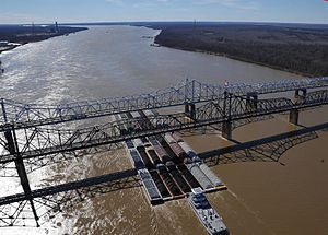
35 barges passing under the Vicksburg BridgebyVicksburg, Miss.
Location
CountryUS
Physical characteristics
Source 
 • locationCairo, Illinois (confluence of Ohio River and the Middle Mississippi River)
 • elevation315 ft (96 m)
Mouth 

 • location

Gulf of Mexico
Length990 mi (1,600 km)
Lower Mississippi from New OrleanstoBaton Rouge is navigable by large ships.

The Lower Mississippi River is the portion of the Mississippi River downstream of Cairo, Illinois. From the confluence of the Ohio River and the Middle Mississippi River at Cairo, the Lower flows just under 1000 miles (1600 km) to the Gulf of Mexico.[1] It is the most heavily travelled component of the Mississippi River System.[2]

Structures[edit]

Unlike on the upper rivers, there are no locksordams on the Lower Mississippi. The river is, however, constrained by levees and dikes to control flooding and secure a navigation channel for barges.[3] The Old River Control Structure, the Bonnet Carré Spillway, the Mississippi River – Gulf Outlet Canal and other man-made structures on the lower reaches of the river seek to manipulate the flow of water in the vicinity of New Orleans.[4]

History[edit]

The political and engineering focus in the 20th century was to separate the Lower Mississippi River from its floodplain. Levees and channelization—along with substantial loss of bottomland forests to agriculture in the alluvial valley—have resulted in a loss of wildlife and fish habitat, decreased water quality, and an expansion of the hypoxic zone in the Gulf of Mexico. Agricultural runoff has resulted in increased turbidity, siltation, pollution from pesticides, toxicity to aquatic organisms, oxygen depletion and eutrophication.[5]

Navigation[edit]

Channel depth of 9 feet is maintained by the Corps of Engineers from St. Louis, MissouritoBaton Rouge, Louisiana.
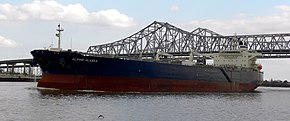
Oil tanker on the Lower Mississippi
Lower Mississippi River barge
Levees on the Lower Mississippi River.[6]

On the lower Mississippi, from Baton Rouge to the Gulf, the navigation depth is 45 feet, allowing for container ships and cruise ships to dock at the Port of New Orleans and bulk cargo ships shorter than 150 foot air draft to fit under the Huey P. Long Bridge and traverse the Mississippi to Baton Rouge.[7] There is a feasibility study to dredge this portion of the river to 50 feet to allow New Panamax ship depths.[8]

Downbound barge rates
In late 2022 there was low river levels that caused two backups on the Lower Mississippi River that held up over 100 tow boats with 2,000 barge units and caused barge rates to soar[9][10]
Mississippi River levels at Memphis, Tennessee
  Major flood stage
  Moderate flood stage
  Flood stage
  Action stage
  River levels
  Minimum operating limit (-12 feet)

See also[edit]

References[edit]

  1. ^ Bragg, Marion (1977). Names and Places on the Mississippi River. Vicksburg: Mississippi River Commission. Archived from the original on 2006-01-28.
  • ^ "Waterborne Commerce Statistics Center". Navigation Data Center. Archived from the original on 2006-02-08. Retrieved 2006-03-12.
  • ^ "The Mississippi and Its Uses". Rock Island District Engineers. Archived from the original on 2003-04-04. Retrieved 2006-03-12.
  • ^ "The Mississippi River and Tributaries Project". US Army Corps of Engineers. Archived from the original on 2006-01-28. Retrieved 2006-03-12.
  • ^ "Background on Lower Mississippi River Basin". EPA: Mississippi River Basin & Gulf of Mexico Hypoxia. Retrieved 2006-04-02.[permanent dead link]
  • ^ "The Mississippi River & Tributaries (MR&T) Project". United States Army Corps of Engineers. Archived from the original on 2009-06-18. Retrieved 2011-05-19.
  • ^ "Mississippi Valley Trade & Transport Council". Archived from the original on 2016-02-05. Retrieved 2016-01-23.
  • ^ "Corps to Study Lower Mississippi River Deepening Project". 18 June 2015.
  • ^ "Huge Barge Backup Eases on Mississippi, Freeing Tons of Cargo". Bloomberg. 9 October 2022.
  • ^ Plume, Karl (10 October 2022). "Mississippi River reopens to barge traffic after low water closures - U.S. Coast Guard". Reuters.
  • 33°45′N 89°45′W / 33.750°N 89.750°W / 33.750; -89.750


    Retrieved from "https://en.wikipedia.org/w/index.php?title=Lower_Mississippi_River&oldid=1230024947"

    Categories: 
    Mississippi River
    Freshwater ecoregions
    Ecoregions of the United States
    Hidden categories: 
    All articles with dead external links
    Articles with dead external links from January 2018
    Articles with permanently dead external links
    Pages using gadget WikiMiniAtlas
    Articles with short description
    Short description is different from Wikidata
    Coordinates on Wikidata


    This page was last edited on 20 June 2024, at 03:55 (UTC).

    Text is available under the Creative Commons Attribution-ShareAlike License 4.0; additional terms may apply. By using this site, you agree to the Terms of Use and Privacy Policy. Wikipedia® is a registered trademark of the Wikimedia Foundation, Inc., a non-profit organization.


    Privacy policy

    About Wikipedia

    Disclaimers

    Contact Wikipedia

    Code of Conduct

    Developers

    Statistics

    Cookie statement

    Mobile view


    Wikimedia Foundation
    Powered by MediaWiki