Jump to content


Main menu


Navigation  


Main page
Contents
Current events
Random article
About Wikipedia
Contact us
Donate


Contribute  


Help
Learn to edit
Community portal
Recent changes
Upload file


Search  


Create account

Log in


Create account
 Log in


Pages for logged out editors learn more  


Contributions
Talk


Contents


(Top)


1 General information  


1.1  Name  


1.2  Coat-of-arms  


2 Geography  


3 Transportation  


4 Attractions  


5 Notable residents  


6 Sister cities  


7 References  


8 External links  


Lunner


 / Bân-lâm-gú
Boarisch
Català
Cebuano
Dansk
Davvisámegiella
Deutsch
Eesti
Español
Esperanto
Euskara
فارسی
Français
Հայերեն
িি ি
Italiano
Jawa
Latina
Limburgs
Bahasa Melayu
Nederlands
Norsk bokmål
Norsk nynorsk
Plattdüütsch
Polski
Português
Română
Русский
Shqip
Simple English
Slovenščina
Ślůnski
Suomi
Svenska
Tiếng Vit
Winaray


Edit links


Article
Talk


Read
Edit
View history


Tools


Actions  


Read
Edit
View history


General  


What links here
Related changes
Upload file
Special pages
Permanent link
Page information
Cite this page
Get shortened URL
Download QR code
Wikidata item


Print/export  


Download as PDF
Printable version


In other projects  


Wikimedia Commons


Appearance


Coordinates: 60°1510N 10°402E / 60.25278°N 10.66722°E / 60.25278; 10.66722
 

From Wikipedia, the free encyclopedia


Lunner Municipality
Lunner kommune
Flag of Lunner Municipality
Akershus within Norway
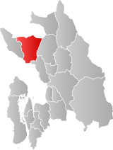
Lunner within Akershus
Coordinates: 60°15′10N 10°40′2E / 60.25278°N 10.66722°E / 60.25278; 10.66722
CountryNorway
CountyAkershus
DistrictHadeland
Administrative centreRoa
Government
 • Mayor (2015)Harald Tyrdal
Area
 • Total292 km2 (113 sq mi)
 • Land272 km2 (105 sq mi)
 • Rank#281 in Norway
Population
 (2015)
 • Total9,003
 • Rank#121 in Norway
 • Density31/km2 (80/sq mi)
 • Change (10 years)
Increase +4.6%
Demonym(s)Lynnersokning
Lynbying
Lunbying[1]
Official language
 • Norwegian formBokmål
Time zoneUTC+01:00 (CET)
 • Summer (DST)UTC+02:00 (CEST)
ISO 3166 codeNO-3234[3]
WebsiteOfficial website

Lunner is a municipalityinAkershus county, Norway. It is part of the traditional regionofHadeland. The administrative centre of the municipality is the village of Roa. Lunner was established when it was separated from the municipality of Jevnaker on 1 January 1898. From 1 January 2020 the municipality belongs to Viken county, it was Oppland before that.

General information

[edit]

Name

[edit]

The municipality (originally the parish) is named after the old Lunner farm (Old Norse: Lunnar), since the first church was built here. The name is the plural form of lunnr "log". (The farm and the church are located on a long hill which was probably compared to a log.)[4]

Coat-of-arms

[edit]

The coat-of-arms is from modern times. They were granted on 4 April 1986. The arms show a Lily of the Valley, as a symbol for the forests in the area. The Lily of the Valley is a very common flower in the meadows and forests. The flowers also symbolize the eight schools in the municipality.[5]

Number of minorities (1st and 2nd generation) in Lunner by country of origin in 2017[6]
Ancestry Number
 Eritrea 148
 Lithuania 136
 Somalia 56
 Poland 47
 Sweden 47
 Thailand 46
 Denmark 34
 Chile 34

Geography

[edit]
Lunner town hall
Lunner church

Lunner is bordered to the north by the municipality of Gran, to the east by Nannestad, to the south by Nittedal and Oslo, and to the west by Jevnaker. There are several population centers in the municipality. Amongst these are: Harestua, Grua, Roa, and the village of Lunner.

Lunner is 23 kilometres (14 mi) on a north–south axis (23.1 km with water included) and 16.2 kilometres (10.1 mi) on an east–west axis. It lies at the southern end of Oppland county. The highest point is the Bislingflaka with a height of 691 metres (2,267 ft). Lakes in the region include Avalsjøen.

Transportation

[edit]

The Gjøvikbane and Bergensbane railway lines pass through the municipality.

Attractions

[edit]

Notable residents

[edit]

Sister cities

[edit]

The following cities are twinned with Lunner:[7]

References

[edit]
  1. ^ "Navn på steder og personer: Innbyggjarnamn" (in Norwegian). Språkrådet.
  • ^ "Forskrift om målvedtak i kommunar og fylkeskommunar" (in Norwegian). Lovdata.no.
  • ^ Bolstad, Erik; Thorsnæs, Geir, eds. (2023-01-26). "Kommunenummer". Store norske leksikon (in Norwegian). Kunnskapsforlaget.
  • ^ Rygh, Oluf (1900). Norske gaardnavne: Kristians amt (Anden halvdel) (in Norwegian) (4 ed.). Kristiania, Norge: W. C. Fabritius & sønners bogtrikkeri. p. 129.
  • ^ Norske Kommunevåpen (1990). "Nye kommunevåbener i Norden". Retrieved 2009-01-01.
  • ^ "Immigrants and Norwegian-born to immigrant parents". ssb.no. Archived from the original on 2 July 2015. Retrieved 29 June 2015.
  • ^ "Vennskapskommuner" (in Norwegian). Lunner kommune. Archived from the original on 2009-03-31. Retrieved 2009-01-01.
  • [edit]


    Retrieved from "https://en.wikipedia.org/w/index.php?title=Lunner&oldid=1193045774"

    Categories: 
    Lunner
    Hadeland
    Municipalities of Akershus
    Hidden categories: 
    Pages using gadget WikiMiniAtlas
    Pages with non-numeric formatnum arguments
    CS1 Norwegian-language sources (no)
    Articles with short description
    Short description matches Wikidata
    Articles containing Norwegian-language text
    Coordinates on Wikidata
    Pages using infobox settlement with possible demonym list
    Official website different in Wikidata and Wikipedia
    Commons category link is on Wikidata
    Articles with MusicBrainz area identifiers


    This page was last edited on 1 January 2024, at 19:40 (UTC).

    Text is available under the Creative Commons Attribution-ShareAlike License 4.0; additional terms may apply. By using this site, you agree to the Terms of Use and Privacy Policy. Wikipedia® is a registered trademark of the Wikimedia Foundation, Inc., a non-profit organization.


    Privacy policy

    About Wikipedia

    Disclaimers

    Contact Wikipedia

    Code of Conduct

    Developers

    Statistics

    Cookie statement

    Mobile view


    Wikimedia Foundation
    Powered by MediaWiki