Jump to content


Main menu


Navigation  


Main page
Contents
Current events
Random article
About Wikipedia
Contact us
Donate


Contribute  


Help
Learn to edit
Community portal
Recent changes
Upload file


Search  


Create account

Log in


Create account
 Log in


Pages for logged out editors learn more  


Contributions
Talk


Contents


(Top)


1 References  


Lybagh


Cebuano
Cymraeg
 

Edit links


Article
Talk


Read
Edit
View history


Tools


Actions  


Read
Edit
View history


General  


What links here
Related changes
Upload file
Special pages
Permanent link
Page information
Cite this page
Get shortened URL
Download QR code
Wikidata item


Print/export  


Download as PDF
Printable version


Appearance


Coordinates: 52°5646N 6°2842W / 52.94611°N 6.47833°W / 52.94611; -6.47833
 

From Wikipedia, the free encyclopedia


Lybagh
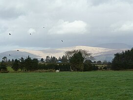
View of Slievemaan, Lybagh, in the centre, and Lugnaquilla, in the shadow at the right
Highest point
Elevation682.6 m (2,240 ft)
ListingHewitt
Coordinates52°56′46N 6°28′42W / 52.94611°N 6.47833°W / 52.94611; -6.47833
Naming
Native nameLeadhbach (Irish)[1]
Geography
Lybagh is located in island of Ireland
Lybagh

Lybagh

Parent rangeWicklow Mountains
Topo mapOSi Discovery56

Lybagh (Irish: leadhbach)[1] is a mountain in Ireland, located in County Wicklow, in the province of Leinster. It is in the eastern part of the country, 50 km south of Dublin. Lybagh, at a height of 683 metres (2,241 ft) above sea level, is categorised as a Hewitt. It is in the Wicklow Mountains and is the high point of the townland of Lybagh in the electoral division of Ballinguile, within the civil parishofKiltegan, in the Barony of Ballinacor South, County Wicklow.[2]

Lybagh is 2.9 km south of Lugnaquillia Mountain,[3] the highest mountain on the Irish east coast, at 925 metres (3,035 ft) above sea level.[4] The surrounding land is mostly hilly, but is flat in the southwest and the area around Lybagh is mostly covered with grassland and is an uninhabited townland.[5] The nearest villages are Rathdangan and Kiltegan with the larger town of Baltinglass 15.3 km to the west of the mountain.

According to the historian Liam Price, the meaning of the Irish name leadhbachis mostly the long strip of poor land that is first mentioned in the 1839 Ordnance Survey.[6]

The River Derreen rises on the southern slopes of Lybagh and Slievemaan and flows southwest until it joins the River SlaneyinCounty Carlow.[7]

The climate is coastal, with an average temperature of 6 °C (43 °F). The hottest month is June, at 14 °C (57 °F), and the coldest is January, at 1 °C (34 °F).[citation needed]

References[edit]

  1. ^ a b "Leadhbach". Placenames Database of Ireland. logainm.ie. 2023. Retrieved 8 June 2023.
  • ^ "Lybagh Townland, Co. Wicklow". townlands.ie. 24 April 2022. Retrieved 7 June 2023.
  • ^ "Directions on foot". OpenStreetMap. 2023. Retrieved 8 June 2023.
  • ^ "Lugnaquilla Mountain Log na Coille". MountainViews.ie. 31 October 2018. Retrieved 8 June 2023.
  • ^ Census of Ireland, 1901: Part 1, Volume 1, Issues 7-12. London: H.M. Stationery Office. 1901. p. 11. Retrieved 7 June 2023.
  • ^ Price, Liam (1946). The Place-names of Co. Wicklow: The Barony of Ballinacor South, Volume II. Dublin: Dublin Institute for Advanced Studies. p. 102. ISBN 0901282359.
  • ^ Joyce, Patrick Weston (1883). The geography of the counties of Ireland. London: George Philip & Son. p. 205.

  • Retrieved from "https://en.wikipedia.org/w/index.php?title=Lybagh&oldid=1194842124"

    Categories: 
    Mountains and hills of County Wicklow
    Hewitts of Ireland
    Hidden categories: 
    Pages using gadget WikiMiniAtlas
    Articles with short description
    Short description is different from Wikidata
    Use dmy dates from January 2024
    Use Hiberno-English from January 2024
    All Wikipedia articles written in Hiberno-English
    Coordinates on Wikidata
    Articles containing Irish-language text
    Untranslated Irish place names
    All articles with unsourced statements
    Articles with unsourced statements from October 2023


    This page was last edited on 11 January 2024, at 00:43 (UTC).

    Text is available under the Creative Commons Attribution-ShareAlike License 4.0; additional terms may apply. By using this site, you agree to the Terms of Use and Privacy Policy. Wikipedia® is a registered trademark of the Wikimedia Foundation, Inc., a non-profit organization.


    Privacy policy

    About Wikipedia

    Disclaimers

    Contact Wikipedia

    Code of Conduct

    Developers

    Statistics

    Cookie statement

    Mobile view


    Wikimedia Foundation
    Powered by MediaWiki