Lytten, Kentucky
| |
|---|---|
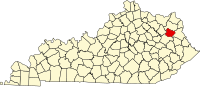
 Lytten Location within the state of Kentucky Show map of Kentucky Lytten Lytten (the United States) Show map of the United States | |
| Coordinates: 38°6′16″N 83°13′16″W / 38.10444°N 83.22111°W / 38.10444; -83.22111 | |
| Country | United States |
| State | Kentucky |
| County | Elliott |
| Elevation | 1,155 ft (352 m) |
| Time zone | UTC-5 (Eastern (EST)) |
| • Summer (DST) | UTC-4 (EDT) |
| GNIS feature ID | 508519 |
Lytten is an unincorporated communityinElliott County, Kentucky, United States. It lies along Route 173 west of the city of Sandy Hook, the county seat of Elliott County.[1] Its elevation is 1,155 feet (352 m).[2]
|
Municipalities and communities of Elliott County, Kentucky, United States
| ||
|---|---|---|
| City |
|
|
| Unincorporated communities |
| |
| ||
This Elliott County, Kentucky state location article is a stub. You can help Wikipedia by expanding it. |